
Sundaland: The Continent That Really Did Drown
An area the size of India went under water while people were living on it. What they were doing there is the argument. And the research file this page works from is rated one out of five for sources, cites twenty of them, and is the only file in this series that flagged a retracted paper.
There is a lost continent under Southeast Asia and it is not controversial. At the height of the last ice age the sea was about a hundred and twenty metres lower than it is now, and the shallow shelf joining Borneo, Sumatra, Java, Bali and the Malay Peninsula was dry land. About 1.8 million square kilometres of it, forested, crossed by rivers the size of the Amazon.
Then the ice melted and it went under, not smoothly but in surges. People were living on it the whole time. Everything after that sentence is where the argument starts.
01The Land That Was There
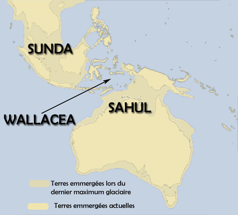
Sundaland is the continental shelf of Southeast Asia, exposed when sea levels were low. At the Last Glacial Maximum, roughly 26,000 to 19,000 years ago, it joined Borneo, Sumatra, Java, Bali and the Malay Peninsula into one landmass of about 1.8 million square kilometres, crossed by great river systems and covered in tropical forest. Global sea level was then about 120 to 130 metres below today's. The flooding was complete by roughly 6,000 to 5,000 years ago.
Harold Voris published reconstructions in the Journal of Biogeography in 2000 showing Sundaland's coastlines at 5,000-year intervals through the post-glacial rise. Our file adds two details worth keeping: the paleo-Sunda river system drained north into the South China Sea with a catchment rivalling the modern Amazon, and the flooding was not gradual. Meltwater pulses at about 14,600 and about 11,300 years ago drowned vast lowlands within centuries, possibly within decades.
02Who Was Standing On It
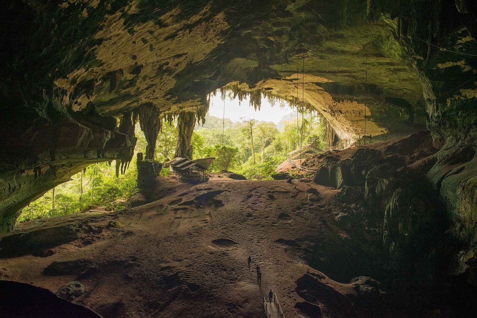
Modern human remains from Niah Cave in Sarawak are dated to about 45,000 years ago, among the oldest Homo sapiens fossils in Southeast Asia, published by Graeme Barker and colleagues in the Journal of Human Evolution in 2007. Homo luzonensis remains from Callao Cave in the Philippines are dated to about 67,000 years, published in Nature in 2019. And Sundaland was the staging ground for the colonisation of Sahul at about 65,000 years ago, which required open-water crossings of at least 60 to 90 kilometres. Both of those identifiers, in a file rated one out of five for its sources, resolve exactly.
Vincent Macaulay, Catherine Hill, Alessandro Achilli and colleagues published in Science in 2005. Verbatim from the abstract: "We show that mitochondrial DNA variation in isolated 'relict' populations in southeast Asia supports the view that there was only a single dispersal from Africa, most likely via a southern coastal route, through India and onward into southeast Asia and Australasia. There was an early offshoot, leading ultimately to the settlement of the Near East and Europe, but the main dispersal from India to Australia ~65,000 years ago was rapid, most likely taking only a few thousand years." OUR FILE CITES THIS PAPER CORRECTLY AND GIVES NO IDENTIFIER FOR IT. One was found and is linked below.
Our file's section on deep antiquity gives the Tam Pa Ling remains in Laos as about 63,000 years old, citing Demeter and colleagues, 2012. The bibliography entry for that exact paper, five screens further down the same document, is titled "Anatomically Modern Human in Southeast Asia (Laos) by 46 ka". The registry confirms that title word for word. THE BODY SAYS 63,000 AND THE ROW BELOW IT SAYS 46,000. No outside source is needed to see it.
03Eden In The East
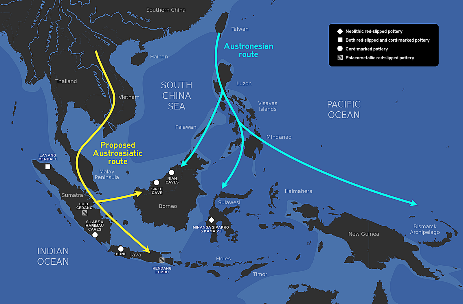
Stephen Oppenheimer's Eden in the East of 1998 proposed that Sundaland was the homeland of a maritime-adapted population progressively displaced by the rising sea, carrying agriculture, pottery and flood mythology outward to mainland Asia, Taiwan, Melanesia, Polynesia and possibly India. Our file's own verdict is the right one and worth quoting in shape: the thesis is taken seriously in genetics and has influenced the debate, but THE CIVILISATIONAL CLAIMS REMAIN AHEAD OF THE ARCHAEOLOGICAL EVIDENCE. It also names the specific weakness rather than gesturing at one: Oppenheimer leans on genetic clock estimates whose calibration assumptions can move dates by thousands of years.
The Austronesian language family is the largest in the world by number of languages, about 1,257 of them, running from Madagascar to Easter Island and Taiwan to New Zealand, with the main expansion between roughly 5,500 and 3,000 years ago. The Out of Taiwan model has the languages originating in Taiwan about 5,500 years ago and spreading south. Gray and colleagues applied Bayesian phylogenetic methods to the languages in 2009 and got a Taiwan origin at about 5,200 years.
Its suggestion is that Austronesian languages may indeed have spread from Taiwan while being carried by populations with deep genetic roots in Sundaland and Southeast Asia: a linguistic expansion over a pre-existing genetic substrate. That is a more useful sentence than either camp's slogan, and it is our file's own rather than borrowed.
04The Boats Are The Strong Part
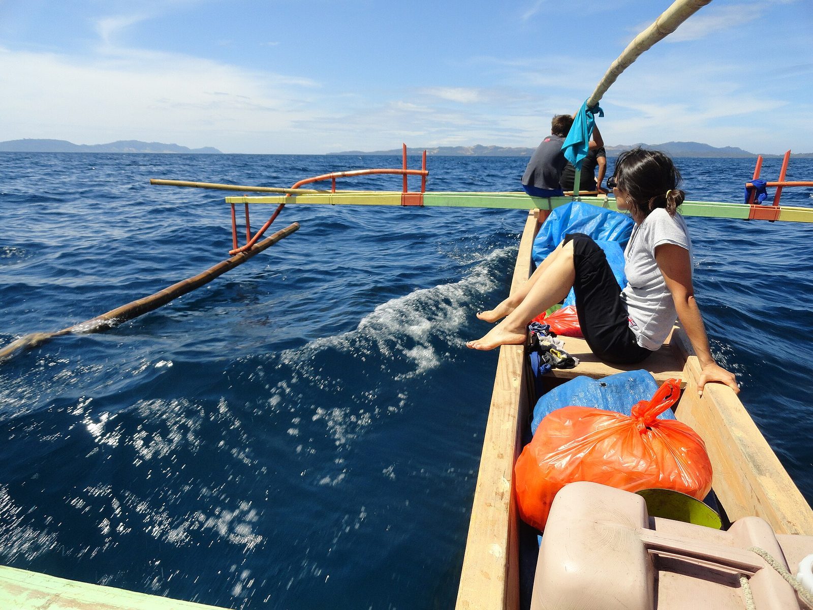
Colonising Sahul required eight to ten island-hopping crossings across Wallacea, with minimum open-water distances of 60 to 90 kilometres. That is beyond the range of accidental rafting and implies intentional navigation, at about 65,000 years ago. Deep-sea tuna bones at Jerimalai Cave in Timor-Leste at about 42,000 years show offshore fishing, and fishhooks were identified there at about 23,000 years. Our file's closing note is the honest one: wooden boats, nets and fibre do not survive in tropical marine conditions, so absence of evidence carries less weight here than almost anywhere.
05The Pyramid That Was Retracted
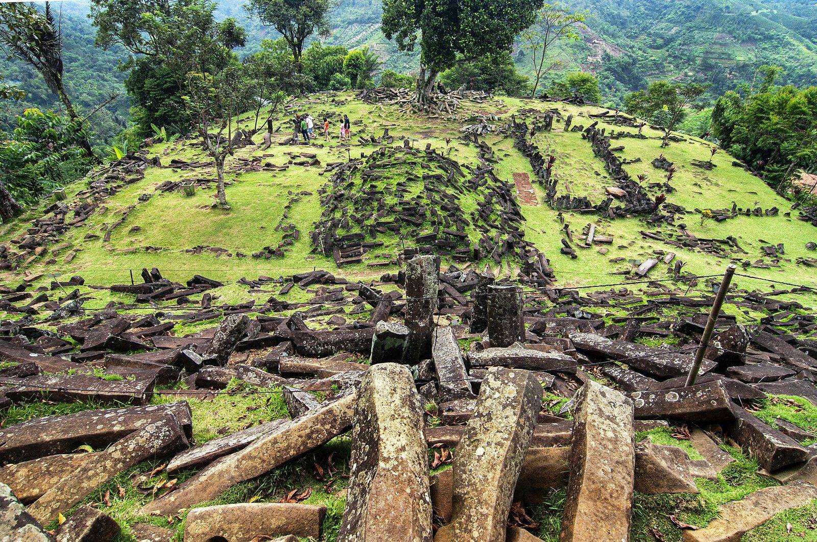
Gunung Padang has controversial radiocarbon dates that were claimed to indicate construction phases as early as about 20,000 years ago. Our file records the dispute by name rather than picking a side: critics argue the deeper layers are natural columnar andesite rather than human construction. It keeps the whole megalithic-origin idea in its speculative section, pending further excavation.
The bibliography entry for the Gunung Padang paper in our own research file carries the note: RETRACTED 2024, peer-review irregularities, methodological concerns. That checks out. The registry now lists the paper's own title beginning with the word RETRACTED, and a separate retraction notice exists in Archaeological Prospection, volume 31, page 199, 2024, recorded with update type retraction, sourced to Retraction Watch, dated 18 March 2024. NOT ONE OF THE FOURTEEN HIGHER-RATED RESEARCH FILES AUDITED IN THIS SERIES HAS FLAGGED A RETRACTION IN ITS OWN BIBLIOGRAPHY. This one, rated lowest of all of them, did.
Eileen Ernenwein published a reflection on the episode in ArchéoSciences in 2025. Its abstract is three lines long and is quoted here entire, because the shape of it is the point: "False claim of World's oldest pyramid published due to peer review oversights, Evolving scholarly publishing practices are negatively impacting academic integrity, Archaeological Prospection methods are increasingly exploited for fringe narratives." Our file does not cite it.
Our file refuses a list, and the refusals are good ones. That Sundaland was Atlantis or Mu, which confuses a real geological question with fiction. That it hosted a technologically advanced Pleistocene civilisation, when every known site shows hunter-gatherer or early horticultural economies. That satellite imagery shows pyramids or cities on the Sunda shelf, which are natural features or sonar artefacts. That the Yonaguni Monument is a Sundaland-era construction, when the geology shows natural sandstone jointing. AND IT NAMES THE ACTUAL HARM: alternative-history authors cite Sundaland to borrow scientific credibility, which distorts both the real evidence and Oppenheimer's own carefully argued case.
06A Note On Our Own Sources, In Which The Score Is The Problem
Every article in this series resolves the identifiers in the research file behind it and reports what comes back. Four previous articles have also quoted a measured correlation: files rated four or five out of five for Source Confidence carry about ninety-one per cent correct identifiers, and files rated two or three about twenty-nine per cent. This file is rated one.
Voris on the sea-level maps, Barker on Niah Cave, Demeter on Tam Pa Ling and Détroit on Homo luzonensis all resolve exactly, matching author, title, journal, volume, issue, pages and year in every case. The fifth is attached to Oppenheimer's 1998 book and resolves to John Edward Terrell's two-page review of it in Current Anthropology in 1999. The tell was visible before anything was resolved: a University of Chicago Press identifier sitting on a Weidenfeld and Nicolson trade book.
The header of this file says Source Count: 0 and Source Confidence: 1 out of 5. THE BIBLIOGRAPHY HAS TWENTY ENTRIES. The footer of the same document says, in its own words, consolidated from 20 sources. The confidence rating is derived from a count that the document refutes two screens further down. This is not a weak signal being over-read. It is an instrument reading a broken input and producing a number that is not merely imprecise but backwards.
| Research File | Source Confidence | Identifiers Correct |
|---|---|---|
| N_2_04, the Nizari Ismailis | 3 of 5 | 0 of 5. Four reviews standing in for the books they review, and a modern extract standing in for Marco Polo |
| W_1_16, the Hittites | 3 of 5 | 6 of 9. Two review-DOIs and one citation whose every locator had drifted |
| ZF_2_22, the hadal zone | 4 of 5 | 10 of 13. Three identifiers landing in the right journal and the wrong article |
| F_4_07, Sundaland, this file | 1 of 5, from a recorded source count of ZERO | 4 of 5, on a bibliography of twenty entries. AND IT IS THE ONLY ONE OF THE FOUR THAT FLAGGED A RETRACTION |
The last entry in this file's bibliography reads: Pelejero and colleagues, 1999, "High-Resolution U-Y_1_06 Temperature Reconstructions in the South China Sea", Paleoceanography 14(2):224-231. The real title is "High-resolution UK37 temperature reconstructions in the South China Sea over the past 220 kyr". UK37 is the alkenone unsaturation index, ordinary palaeothermometry notation with a superscript and a subscript. Y_1_06 IS A DOCUMENT IDENTIFIER FROM THIS LIBRARY. Something that walks the corpus rewriting cross-references has read a scientific notation as a link and written a filing number into the title of a citation. THE JOURNAL, VOLUME, PAGES AND YEAR ARE ALL UNTOUCHED AND CORRECT, which is precisely why the mechanism is visible instead of just the damage.
Fifteen entries in this bibliography carry no identifier at all, and five of them were found: Pelejero 1999 in Paleoceanography, Lambeck and colleagues 2014 on sea level and global ice volumes in PNAS, Clarkson and colleagues 2017 on human occupation of northern Australia by 65,000 years ago in Nature, Macaulay and colleagues 2005 in Science, and the Gunung Padang retraction notice itself. EVERY ONE OF THOSE CITATIONS WAS ALREADY CORRECT except for the missing pointer, and in Pelejero's case the corrupted title. The other ten were not searched individually and are recorded here as unchecked, which is not the same as clean and not the same as wrong.
Verbatim: "No significant counter-arguments exist in the scholarly literature for the core claims presented here... with no active scholarly dispute over the fundamental claims presented in this document." The same document calls Oppenheimer's thesis contested, describes a live dispute between two named research groups over Gunung Padang, and devotes a whole section to refusing four popular claims. THIS IS THE THIRD FILE IN THIS SERIES CARRYING THAT EXACT SENTENCE while the dispute sits a screen above it. It reads like boilerplate because it is.
Fast Facts
- The Landmass
- About 1.8 million square kilometres of continental shelf, dry at the last glacial maximum
- The Sea Level
- About 120 to 130 metres below today's, roughly 26,000 to 19,000 years ago
- The Drowning
- Complete by roughly 6,000 to 5,000 years ago, with meltwater surges at about 14,600 and 11,300 years ago
- The Oldest Bones
- Niah Cave, Sarawak: modern humans at about 45,000 years ago
- The Crossing
- Sahul was reached about 65,000 years ago, over water gaps of at least 60 to 90 kilometres
- The Language Family
- Austronesian, about 1,257 languages, Madagascar to Easter Island
- The Thesis
- Oppenheimer, Eden in the East, 1998. Taken seriously in genetics; the civilisational claims run ahead of the archaeology
- The Retraction
- The Gunung Padang pyramid paper was retracted in March 2024, and our own file says so
- Our File's Score
- Source Confidence 1 of 5, from a recorded source count of zero
- Our File's Actual Sources
- Twenty. Five carry identifiers and four of those five are exactly right
What We Can Actually Stand Behind
Sundaland existed, covered about 1.8 million square kilometres, and drowned between roughly 14,600 and 5,000 years ago, in surges rather than smoothly. Modern humans were at Niah Cave about 45,000 years ago and Sahul was reached about 65,000 years ago across open water. Southeast Asia carries among the world's highest genetic diversity. The Austronesian family is the largest by number of languages. The Gunung Padang paper was retracted in March 2024. And in our own research file, four of five identifiers resolve exactly, five more were recovered, and its own recorded source count of zero is wrong by twenty.
That rising seas displaced large Sundaland populations and drove migrations, which is the demographic core of Oppenheimer's argument and is consistent with both the genetics and the spread of Austronesian languages. That maritime technology in the region is extremely old, on the strength of the Sahul crossings and the Jerimalai fishhooks. And that Austronesian languages spread from Taiwan while being carried by populations with deep genetic roots in Sundaland and Southeast Asia, which is our file's own synthesis.
That the concentration of flood myths in the region preserves memory of the actual inundation. That Sundaland was the source of a megalithic tradition. And Gunung Padang's disputed deep chronology, where the paper making the strongest claim has now been retracted and the surface stones are prismatic in exactly the way natural columnar jointing produces.
Sundaland as Atlantis or Mu. A technologically advanced Pleistocene civilisation, which no site supports. Pyramids or cities visible in seafloor imagery. The Yonaguni Monument as a Sundaland construction. All four are refused by our own file, and it also names the reason they keep circulating, which is that a real drowned continent is useful cover for claims that have nothing else holding them up.
The thing worth taking from this one is not about Sundaland. It is that the file with the worst score in the library turned out to be one of the more honest documents in it. It refuses the popular nonsense by name, it says out loud where its favoured hypothesis runs ahead of the evidence, it names the two sides of a live scientific dispute, and it is the only file yet audited here that noticed one of its own sources had been withdrawn. Its confidence rating says one out of five, and that rating was computed from a source count of zero for a document with twenty sources. A number can be precise, prominently displayed, and about nothing at all.
Sources & further reading
WHERE THIS WORKED FROM. One file in our own research library, F_4_07, plus eleven external records resolved live on 26 August 2026. THE SUBSTANCE IS OUR FILE'S. The shelf area and sea-level figures, the meltwater pulses, the Niah and Callao and Tam Pa Ling dates, the Sahul crossing, the genetic diversity picture, the Austronesian numbers, Oppenheimer's thesis and our file's own careful verdict on it, the maritime-technology argument, the flood-myth caution and all four Tier 4 refusals come from it. A NOTE ON ITS SCORE. The header of that file records Source Count: 0 and Source Confidence: 1 out of 5. Its bibliography has twenty entries and its own footer says consolidated from 20 sources. Of the five identifiers it carries, four resolve exactly to the works they name. The rating on this file is not a weak signal, it is a broken input, and this page says so because four earlier articles in this series quoted that rating as a triage signal. WHAT THE PAGE ADDS. Macaulay and colleagues in Science in 2005, whose abstract is quoted and whose identifier our file did not carry. Ernenwein in ArchéoSciences in 2025, a peer-reviewed reflection on the Gunung Padang retraction, which our file does not cite. The Gunung Padang retraction notice itself, which confirms our file's own flag. And four further identifiers recovered for entries that carried none: Pelejero 1999, Lambeck 2014, Clarkson 2017 and Macaulay 2005. TWO DEFECTS ARE REPORTED IN SECTION 06. Our file's body dates the Tam Pa Ling remains to about 63,000 years while its own bibliography row for that paper is titled by 46 ka, which the registry confirms word for word. And the last bibliography entry contains the string U-Y_1_06 where the real title has the alkenone index UK37: a corpus filing number has been written into a citation title by something rewriting cross-references, with the journal, volume, pages and year left correct around it. WHAT IS NOT CLAIMED. Ten bibliography entries carrying no identifier were not searched individually and are recorded as unchecked, not as clean and not as wrong. The specific figures for the flood-myth count and the Madagascar founding population rest on those unchecked sources. Nothing here adjudicates Gunung Padang beyond what the retraction record states, and nothing here claims Oppenheimer is refuted; our file's position, that the civilisational claims run ahead of the archaeology, is a different and more accurate statement. ON THE IMAGES. Five were fetched and opened and all five were kept, the first article in this run with no drops. Two carry warnings in their captions: the Austronesian route map draws the mainstream Out of Taiwan model rather than Oppenheimer's, and the outrigger is a working boat in Sulawesi today rather than a reconstruction of anything ancient.
Image credits
- The Niah Great Cave, Sarawak, Malaysia Michael Elleray, via Wikimedia Commons (CC BY 2.0). CC BY 2.0 Source.
- Sunda, Wallacea and Sahul at the Last Glacial Maximum Christophe Cagé, via Wikimedia Commons (CC BY-SA 3.0). CC BY-SA 3.0 Source.
- Proposed Austroasiatic and Austronesian migration routes into Indonesia, with pottery-site distributions Obsidian Soul, via Wikimedia Commons (CC0). CC0 Source.
- An outrigger boat under way to Pulau Bangka, Sulawesi Fabio Achilli, via Wikimedia Commons (CC BY 2.0). CC BY 2.0 Source.
- The megalithic site of Gunung Padang, Cianjur, West Java RaiyaniM, via Wikimedia Commons (CC BY-SA 4.0). CC BY-SA 4.0 Source.


.jpg)
