
Machu Picchu: The City in the Clouds
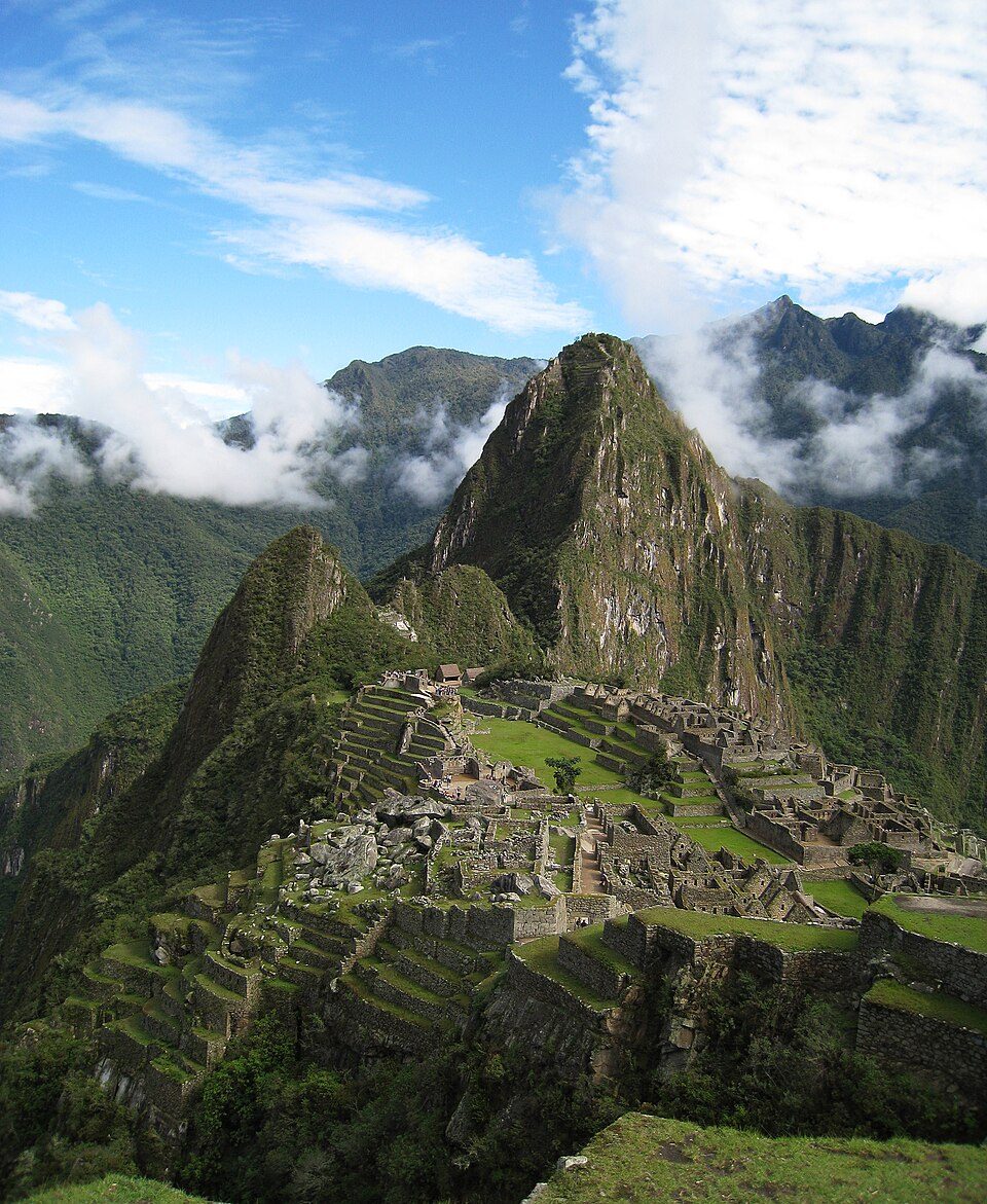
The ridge is a saddle between two peaks, with the ground falling roughly 450 meters to the Urubamba River on three sides. Roughly 1,800 millimeters of rain land on it every year, and a fault zone runs directly underneath. The Inca answer was a stone-lined canal 749 meters long, cut across the mountainside at a gradient held near 3 percent, fed from a spring that still yields about 25 liters a minute at its dry-season low, and emptying into a chain of 16 carved fountains. Underneath the terraces and the plazas they buried gravel beds and stone conduits to take the rain away before it could take the hill away. An engineering study of the site puts 60 percent of the total construction effort into the parts nobody sees. Here is the file, opened claim by claim, each one wearing its evidence.
Start with the rain, because the site starts with the rain. Roughly 1,800 millimeters of it falls on this ridge every year, on ground that drops about 450 meters to the river on three sides, over a fault zone that runs directly beneath the buildings. Steep, wet, and seismically live is a poor specification for a city, and the Inca put one there anyway: around 200 structures, more than 700 agricultural terraces, and a water system that begins at a spring on the mountain's north slope and ends in a chain of 16 carved stone fountains. The part of that system a visitor can photograph is the smaller part of it. Let's open the file.
01A Saddle Between Two Peaks
Machu Picchu stands at 13 degrees 09 minutes 47 seconds south, 72 degrees 32 minutes 44 seconds west, in the Cusco Region of Peru. The site occupies a saddle between Machu Picchu mountain, at 3,082 meters, and Huayna Picchu, at 2,693 meters, with the ground falling away roughly 450 meters to the Urubamba River on three sides. That is a naturally defensible position and a visually dramatic one. It is also the single fact every other fact on this page has to answer to.
The first hazard is water. The site's subsurface drainage was engineered to handle heavy Andean rainfall of roughly 1,800 millimeters a year. The second is the ground itself: geological survey work by Kenneth Wright and Alfredo Valencia Zegarra, published in 2000, identifies the Machu Picchu fault zone running directly beneath the site. The builders clearly recognized the seismic risk, since the trapezoidal doorways, the battered walls, and the keystone construction are all answers to it, and the site's long-term stability remains a live conservation concern.
The Machu Picchu Historic Sanctuary covers 32,592 hectares and spans an ecological transition from high puna grassland at 4,200 meters down to cloud forest at 2,000 meters, with more than 420 documented bird species including the Andean cock-of-the-rock, spectacled bear habitat, and more than 300 species of orchid. That setting is not scenery. The Inca valued the cloud forest for medicinal plants, coca, feathers, and tropical timber, which makes the ecological position part of the site's function rather than a backdrop to it.
Machu Picchu was inscribed on the UNESCO World Heritage List in 1983. Our own research file gives that bare date and nothing else; independent checking of the listing adds the detail that matters for a siting argument. The inscription is a mixed one, made under cultural criteria (i) and (iii) together with natural criteria (vii) and (ix), which is rare on that list. What was inscribed is the landscape as well as the ruins standing in it.
02The Spring, and 749 Meters of Stone
Everything the site does about water begins at a single point on the mountain, and the distance between that point and the city is the first engineering decision anyone made up here.
A perennial spring on the north slope of Machu Picchu mountain, roughly 750 meters from the site center, is the settlement's primary water supply. Its flow at the dry-season minimum is about 25 liters a minute. The spring was not simply found and used, either: it was artificially enhanced, with an upslope collection area designed to maximize how much groundwater it captured.
From the spring, a stone-lined canal 749 meters long carries the water to the urban sector. The channel is small, roughly 10 to 12 centimeters wide and about 12 centimeters deep, and it follows the contour of the mountain at a gradient carefully maintained at about 3 percent along its length.
The word doing the work in that claim is maintained. About 25 liters a minute is not a large flow, and it has to arrive. A gradient is not something a channel acquires by accident across 749 meters of uneven mountainside; it is something a builder holds, section by section, the whole way. The holding is the engineering.
03Sixteen Fountains, In Rank Order
The canal feeds a chain of 16 interconnected fountains: carved stone basins with spouts, drains, and splash guards, arranged as a cascade, each one's outflow feeding the next through carved stone channels.
Fountain 1 sits beside the Temple of the Sun and the emperor's residence, and it was the first in the chain to receive water. The cleanest supply reached the most sacred and highest-status location on the ridge, and everything else in the settlement drank downstream of it. The hydraulic sequence and the social sequence are the same sequence, built into stone.
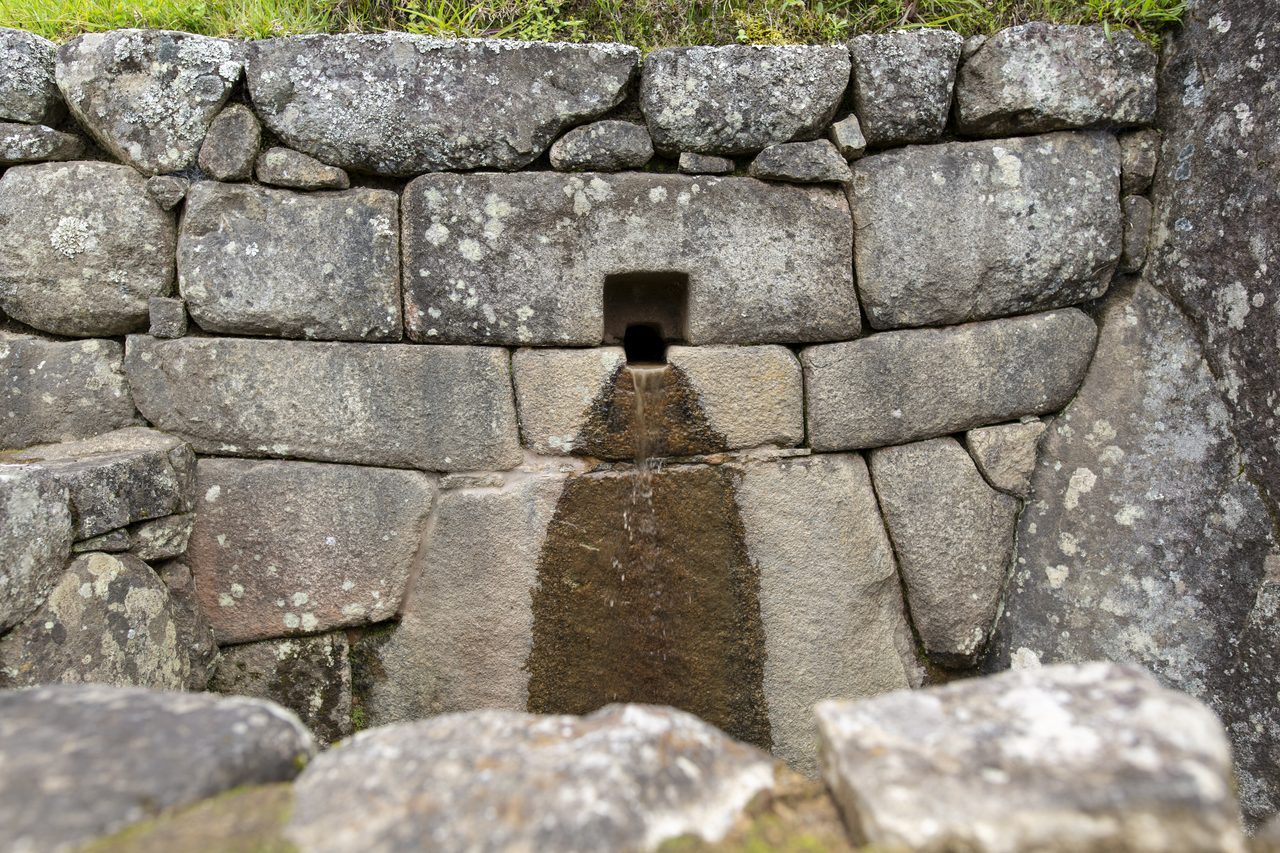
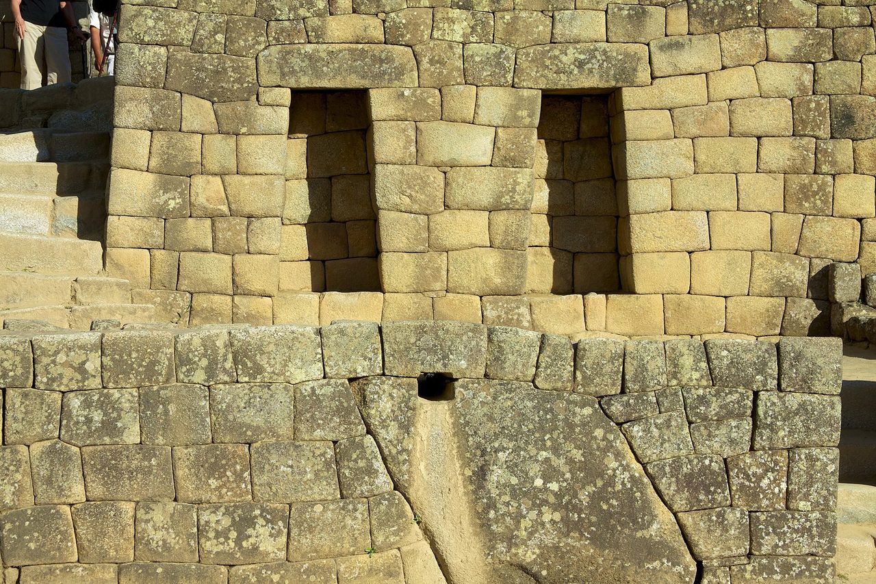
This is the same carved-channel technique that carries water between fountains, downstream of the canal described above.
Wright, Kelly, and Valencia Zegarra's 1997 study of the system demonstrated that the canal-and-16-fountain arrangement achieves near-optimal flow distribution with minimal waste, which our own file calls a masterwork of hydraulic engineering at high altitude.
Our file's summing-up of the whole system is worth carrying in substance: the hydraulic engineering demonstrates a sophisticated understanding of hydrology, soil mechanics, and water management, comparable in technical accomplishment to the best Roman hydraulic systems, and arrived at independently of them.
| Stage | The Measurement | What It Does |
|---|---|---|
| The Spring | Perennial, on the north slope of Machu Picchu mountain, roughly 750 m from the site center; about 25 liters per minute at the dry-season minimum | The whole settlement's supply, artificially enhanced by an upslope collection area built to maximize groundwater capture |
| The Canal | 749 meters, stone-lined, roughly 10 to 12 cm wide and about 12 cm deep, gradient maintained at about 3 percent | Carries the flow along the mountain contour into the urban sector |
| The Fountains | 16 interconnected carved stone basins with spouts, drains, and splash guards | A cascade: each fountain's outflow feeds the next, with Fountain 1, beside the Temple of the Sun and the emperor's residence, first in line |
| The Drainage | Deep layers of gravel and stone chips beneath terraces and plaza surfaces, plus stone-lined conduits | Runs in parallel with the supply, taking roughly 1,800 mm of annual rainfall away before it can waterlog the ground or erode it |
04The Sixty Percent Nobody Sees
Running in parallel with the supply is a drainage system: deep layers of gravel and stone chips beneath the terraces and the plaza surfaces, with stone-lined conduits carrying water away, engineered against roughly 1,800 millimeters of rain a year so the ground neither waterlogs nor erodes. Wright and Valencia Zegarra's 2000 civil-engineering study of the site estimates that 60 percent of Machu Picchu's total construction effort went into that invisible infrastructure, the foundations, the drainage, and the terrace cores, rather than into the visible buildings.
Read that number a second time, because it reorganizes the site. The masonry, the temples, the plazas, the whole photographed surface of Machu Picchu is the minority of the labor spent up here. The majority went underground and stayed there, and it had to go there first, because a wall built on a slope that has not been drained is a wall with a schedule.
A dedicated paper on exactly this subject exists, and our own file does not cite it. Wright and Valencia Zegarra published Ancient Machu Picchu Drainage Engineering in the Journal of Irrigation and Drainage Engineering in 1999, at volume 125, issue 6, pages 360 to 369; it was independently confirmed as real and live through the ASCE Library during this article's research pass. Its subject is the terrace and subsurface drainage system, which is the exact engineering claim at the center of this article. It is listed in this article's sources, rather than left out because our file left it out.
05Seven Hundred Terraces, Built To Drain
More than 700 agricultural terraces cascade down the hillsides around the site, some of them descending more than 500 meters in elevation. Each was built with engineered internal drainage: a base layer of large rocks, a middle layer of gravel, and a topsoil surface on top. Those three layers do two jobs at once, shedding water fast enough to prevent waterlogging while retaining moisture through a dry spell.
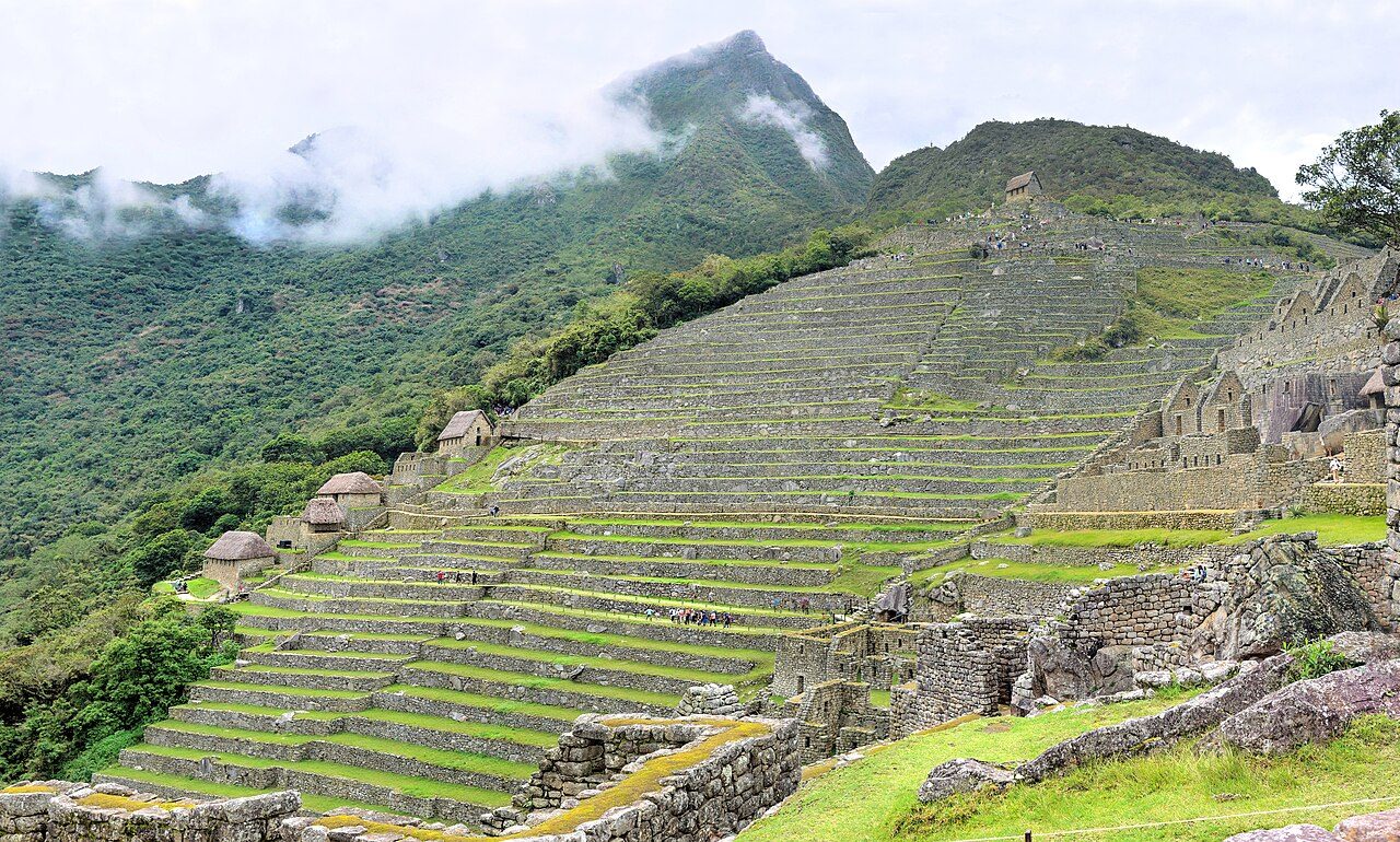
The steep elevation gradient supplies something else at no extra cost. It creates multiple microclimatic zones, so different crops suit different terrace levels: maize lower down, potatoes and quinoa higher up.
Our file adds a possibility here rather than a finding, and the distinction is worth keeping. Some terraces may have functioned as agricultural experimental stations, testing crop varieties against elevation, in the manner of the documented experimental terraces at Moray. Moray's experimental terraces are documented. Machu Picchu's terraces as experiment is a may, and it stays a may here.
Wright's calculations suggest the terraces could have supported only about 55 people at full productivity, far short of the estimated 500 to 750 peak-occupation population our file gives, a figure section 07 shows is not the only one in play. Most food was imported from lower-elevation Inca estates over the road network, which means the settlement was provisioned from outside rather than feeding itself. The honest reading of the terracing follows from that arithmetic: it was engineered primarily against erosion and for microclimate control, and it was never the site's larder.
06What Stands on the Ridge
The site divides in two. An agricultural sector holds the terraces on the southern and eastern slopes; an urban sector holds the structures along the ridge. The urban sector then divides again, into hanan, the upper, sacred and ceremonial half carrying the Temple of the Sun, the Intihuatana pyramid, the Temple of the Three Windows, the Principal Temple, and the elite residences, and hurin, the lower half carrying commoner dwellings, storage buildings or qollqa, workshops, and mortar-grinding stations. That division mirrors the moiety system that organized Inca Cusco.
There are approximately 200 structures in total, about 140 of them in the urban sector. Most are small single-room buildings with trapezoidal doorways and offering niches, roofed with gabled timber frames thatched in ichu grass. The stone walls supported those roofs; they were not carrying a ceiling load.
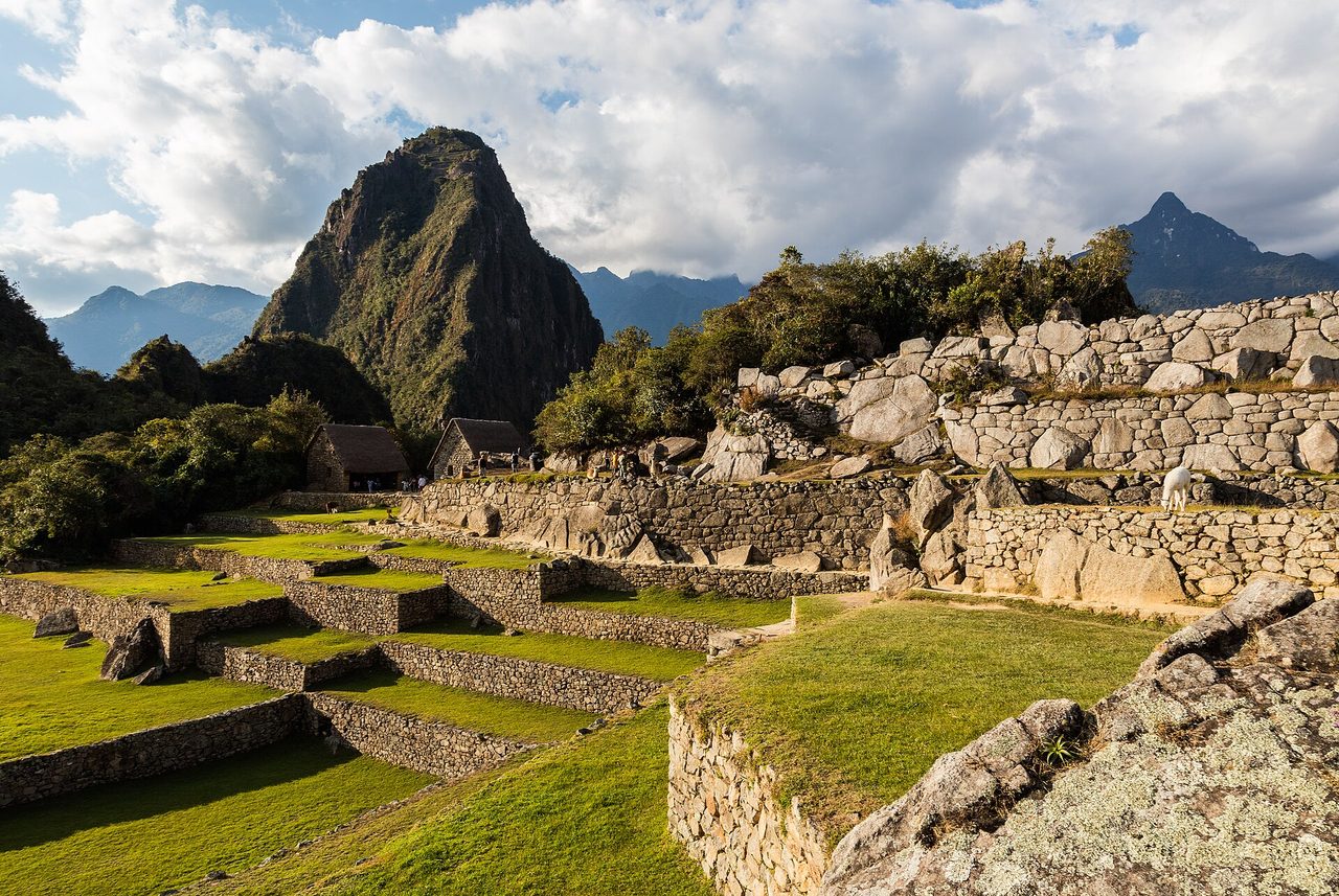
The named buildings: the Temple of the Sun, also called the Torreon, a curved-wall structure with solstice-aligned windows; the Intihuatana, a sculpted stone pillar; the Temple of the Three Windows, which references the Inca origin cave Tambo Toco; the Principal Temple; the Room of the Mortars, with two concave grinding surfaces; and the Sacred Rock, carved to echo the profile of the mountain standing behind it.
The stonework gets a paragraph here and not a section, because the fitted-stone question belongs to two other files in this wing rather than to this one. The most finely finished structures, the Temple of the Sun, the Intihuatana, and the Temple of the Three Windows, are built in precisely fitted ashlar granite, cut and ground to close tightly without mortar. The granite, white leucogranite and grey-green metamorphic rock, was quarried from natural outcrops on the ridge itself, so the building stone never had to come up the mountain. Jean-Pierre Protzen's experimental work, published in 1993, showed Inca masons shaping that granite with river-cobble hammerstones of harder diorite, basalt, and quartzite, pounding and abrading the surface. No metal tools were needed for the cutting, and bronze was reserved for fine detail.
The same building program answers the fault zone under the ridge. Documented anti-seismic features at the site include walls battered inward by roughly 3 to 5 degrees, which lowers the center of gravity; trapezoidal openings, wider at the base than at the top, which distribute stress during shaking; interlocking L-shaped and T-shaped joints that resist lateral displacement; pillow-faced, rusticated blocks whose convex and concave faces let a wall dance and resettle rather than fail; and dry-stone construction that allows controlled movement instead of the catastrophic mortar-cracking collapse a mortared wall suffers. The site was engineered against two different hazards at once. This article is mostly about the wet one.
07Who It Was For, and How Many
A water system is sized for a population, so the population number here is not a piece of trivia. It is a specification. And it is a number this file does not resolve.
Researchers estimate that Machu Picchu supported approximately 750 residents at peak occupation, a figure built from the count and size of residential structures, the capacity of the water supply, and terrace yield. That is a relatively small elite community. Isotopic analysis of skeletal remains shows the inhabitants came from diverse regions across the Inca empire, coast, highlands, and cloud forest alike.
Now the part our own file does not resolve. The same research program that produced the water-system figures also produced a different population number. Wright, Kelly, and Valencia Zegarra's 1997 hydraulic paper, which our file cites in its own bibliography, states that the canal-and-fountain system was engineered to serve an estimated permanent population of 300. Independent checking through the ASCE Library confirms that paper's title and authorship exactly. Our file gives approximately 750 at peak occupation, gives a range of 500 to 750 elsewhere in its own text, and never mentions the 300 or explains the gap. The two numbers most plausibly measure different things, a permanent year-round staff on one hand and a peak occupancy including a visiting royal retinue on the other. That is a reasonable reconciliation. It is not a documented one, so this article states the gap rather than picking a side of it.
One line of evidence leans the same way as that reconciliation without confirming it. Faunal remains, ceramic distribution, and storage capacity suggest occupation peaked seasonally, tied to agricultural cycles and to major Inca festivals such as Inti Raymi, Capac Raymi, and the solstice ceremonies, rather than running at uniform full occupancy year round. A settlement that fills and empties on a calendar is a settlement with two honest population numbers, which is exactly the shape of the discrepancy above.
Bingham's original reading of the site as an aqllawasi, a house of chosen women, rested on a perceived high proportion of female burials. Later osteological analysis, by Verano in 2003 and Turner and colleagues in 2009, found a roughly equal male-to-female ratio and diverse geographic origins. What the bones describe is a multi-ethnic retainer population, not a community of aqllas.
Scholarly consensus, in Rowe's 1990 work, in Burger and Salazar's 2004 volume, and in Niles in 1999, identifies Machu Picchu as a royal estate, the panaca property of Pachacuti, one of roughly 10 to 15 such estates Inca emperors maintained in the Urubamba Valley, the Sacred Valley, alongside Ollantaytambo, Pisac, and Chinchero. This is the reading most other statements about the site get hung on, and it is graded credible rather than verified here because that is how our own file grades it.
The case for it has three parts. Sixteenth-century legal documents, the Informaciones, refer to the site as Picho or Piccho, lands belonging to Pachacuti's panaca. The site's compact size, high-quality construction, and limited agricultural capacity fit a seasonal royal retreat visited by an emperor and a retinue of perhaps 500 to 750 retainers. And the material record is elite: fine Cusco polychrome ceramics, metal artifacts including bronze pins and gold and silver objects, and high-status burials with grave goods.
08Why This Ridge
A royal estate, credibly. That still does not answer the question the ridge itself keeps asking, which is why a builder with the whole Urubamba Valley to choose from picked the one place where every wall would need a drain under it. Part of the answer is at Tier 1 and can be measured. The rest is at Tier 2 and has to be argued.
Stand in the central plaza and each of the four cardinal directions is occupied by a peak: Huayna Picchu to the north, Machu Picchu mountain to the south, Pumasillo in the Vilcabamba range to the west, and Veronica, Wakay Willka in Quechua, to the east. The settlement sits at the center of a mountain-defined geography, and the framing is a fact about where the site was placed rather than an interpretation of why.
The buildings are aimed as well as placed. The Intihuatana, the hitching post of the sun, is a carved polygonal granite pillar roughly 36 centimeters tall rising from a sculpted bedrock platform at the highest point of the urban sector. Four of its corners and edges are roughly oriented to the cardinal directions, and at noon on the March and September equinoxes the sun stands almost directly above it, casting virtually no shadow.
The Temple of the Sun is a semicircular tower whose carefully shaped window admits a shaft of sunlight onto a specific interior point at the June solstice sunrise, with a second window aligned to the December solstice sunrise. It stands on top of a natural cave, the so-called Royal Tomb, which makes a vertical axis running through underworld, earth, and sky.
The Temple of the Three Windows opens three large trapezoidal windows east, toward the Vilcanota and Urubamba canyon. The three are interpreted as a reference to the Inca origin myth of Tambo Toco, the cave of three windows from which the Ayar siblings, the founding ancestors, emerged.
Johan Reinhard's sacred-landscape analysis, published in 2007, is the fullest attempt at why here that our file carries. The Urubamba River makes a near-360-degree bend below the site, which Reinhard reads as mirroring the course of the Milky Way, Mayu in Quechua. The surrounding peaks are identified with specific apus, mountain deities, with Salkantay dominating the southern horizon; Huayna Picchu carries a summit temple platform and served as a ritual observation point; and Putucusi completes a triangulation of sacred peaks. The support for the reading is that modern Quechua-speaking communities in the Cusco region still venerate the same apus, which makes fifteenth-century ritual significance for these mountains a reasonable inference rather than a modern projection onto them. It remains an inference, which is why it is graded credible and not verified.
The ridge was not isolated, either. Machu Picchu connected to Cusco and to the wider empire through the Qhapaq Nan, the Inca royal road system, and specifically through the Inca Trail, the Camino Inca: a paved stone path of roughly 43 kilometers over high passes, reaching about 4,200 meters at Warmiwanusqa, Dead Woman's Pass, with tambos, way-stations, spaced along it. That infrastructure suggests formalized pilgrimage or ceremonial procession routes. And the site's position at the junction of highland and lowland environments, cloud forest and montana, gave strategic access to both Andean and Amazonian resources.
The trail's own architecture is documented in detail. The classic four-day route follows an original Inca road through Llactapata, Runkuraqay, Sayacmarca, Phuyupatamarca, and Winay Wayna before reaching the Sun Gate, each of those a tambo, a religious site, or both, creating a graduated approach of increasing elevation, increasing isolation, and increasing architectural sophistication before Machu Picchu is finally revealed. What that sequence was for is a separate question, and it sits at Tier 3 in section 10.
09Who Built It, and When
AMS radiocarbon dating on human bone puts the earliest occupation at about 1420 CE. The study is Burger and colleagues, published in Antiquity in 2021, and it was independently confirmed through Cambridge Core and Yale Anthropology during this article's research pass: human bone and teeth sampled from four burial-cave cemeteries around the site, giving an overall occupation span of about 1420 to 1532 CE. That start date is roughly two decades earlier than the site's traditional textual association with Pachacuti's rise to power in 1438, and earlier again than the conventional c. 1450 founding estimate our own file names as the previous standard.
That date does something to the standard story. If people were at Machu Picchu by about 1420, and Pachacuti's own reign is conventionally dated from 1438, construction on the traditional accession date began under an immediate predecessor rather than under Pachacuti himself. The royal-estate attribution to Pachacuti, graded credible rather than verified in section 07, is not overturned by this; it is loosened at its start, which is a smaller and more interesting correction than an overturning would be.
The site was likely abandoned in the early decades of the Spanish conquest, somewhere between the 1530s and the 1570s. The cause may have been smallpox epidemics rather than military action, since the Spanish never documented the site at all.
Hiram Bingham III of Yale University reached the site on July 24, 1911, guided there by the local farmer Melchor Arteaga. Two things usually get left out of that sentence. Local farmers were already living on the site and cultivating its terraces when he arrived, the Richarte and Alvarez families among them. And Bingham misidentified what he had found: he took it for Vilcabamba, the last Inca capital.
The discovery narrative has been qualified further since. Augusto Berns, a German engineer, visited in 1867, and possibly others before him.
| Period | Dates | What the Record Shows |
|---|---|---|
| Occupation | About 1420 to 1532 CE | AMS radiocarbon on human bone and teeth from four burial-cave cemeteries (Burger and colleagues, Antiquity, 2021), independently confirmed. The 1420 start is roughly two decades earlier than the traditional association with Pachacuti's rise to power in 1438 |
| Abandonment | About the 1530s to the 1570s | Likely abandoned in the early decades of the Spanish conquest, possibly to smallpox epidemics rather than to military action; the Spanish never documented the site |
| Earlier Visits | From 1867 | Augusto Berns, a German engineer, visited in 1867, and possibly others before him; the discovery narrative has been qualified accordingly |
| Bingham | July 24, 1911 | Hiram Bingham III of Yale University arrived guided by the farmer Melchor Arteaga, with the Richarte and Alvarez families already living on and cultivating the terraces, and initially identified the site as Vilcabamba |
10Where the Story Runs Off the Map
A place this photogenic and this strangely sited pulls big stories toward it. Some of them are real questions with no study behind them yet. The rest fail on the evidence outright, and walking through both kinds plainly is worth the space, because the documented version of this ridge is more interesting than any of the substitutes.
Our file's own counter-arguments section states the skeptical position, and it applies here. Mainstream archaeologists have proposed conventional explanations for the site's construction methods and features; critics argue that attributing anomalous characteristics to unknown technologies underestimates the ingenuity of ancient peoples working with known tools; and experimental archaeology has replicated many supposedly impossible construction feats using tools those builders actually had. Protzen's hammerstone work in section 06 is one instance of that argument being carried out rather than asserted.
Some researchers propose the ridge was sacred or occupied before Pachacuti's construction campaign, citing possibly older terrace walls and the location's spiritual significance. No pre-Inca artifacts or structures have been definitively identified, and the 2021 radiocarbon study confirms occupation only from about 1420 CE onward. That is an absence of positive evidence rather than a refutation, which is why it sits here and not two tiers down.
Preliminary evidence suggests that certain enclosed spaces, the Temple of the Sun and the Royal Tomb cave beneath it, produce notable resonance effects at specific frequencies, and that the Royal Tomb chamber's parabolic rock surfaces create measurable sound amplification. Whether any of that was intentionally designed, or is incidental to granite architecture and natural cave geometry, is unresolved. The open question is whether the space was selected or modified for ritual chanting, and nothing currently on the record answers it.
Researchers including Zadir Milla Euribe have argued that the site's proportions encode Andean mathematical and geometric principles, including relationships to the Andean cross, the chakana, and possible Fibonacci-like ratios. Those claims remain contested and lack peer-reviewed verification. The chakana motif genuinely does appear in Inca architecture and textiles; mathematical encoding at the level of site planning is undemonstrated, and the two statements are not the same statement.
A further proposal connects Machu Picchu to Cusco's ceque system, the radial network of sacred lines originating at the Coricancha temple, as a distant huaca. No documentary or archaeological confirmation that a ceque line reached Machu Picchu has been found.
And the approach itself. The Inca Trail climbs through cloud forest and high passes before descending to the Sun Gate, Intipunku, where the site is revealed in its entirety at once, which has led scholars to speculate that the journey was a structured initiation experience or pilgrimage route with that revelation as its climactic moment. The trail infrastructure and its way-stations are documented at Tier 1 in section 08. The specific ritual significance of the approach is unrecorded, and that is the part sitting here.
No, Machu Picchu was not built by or for extraterrestrial entities. There is no archaeological support of any kind for the claim, and the construction techniques, remarkable as they are, are consistent with Inca engineering documented across the empire at Ollantaytambo, Sacsayhuaman, Pisac, and Moray.
No, the site is not tens of thousands of years old. Assertions that it is contradict all the radiocarbon evidence, the ceramic typology, and the architectural dating at once.
No, the hydraulic system was not a power plant. Reading the water works as an energy-generation facility misconstrues the engineering as something more exotic than it is. What the spring, the 749-meter canal, and the 16 fountains constitute is an elegant gravity-fed water distribution system: plumbing, done extremely well, at high altitude, on a slope, against 1,800 millimeters of rain a year. This whole article argues that the plumbing is the impressive part, which makes it a strange thing to trade away for a better-sounding story.
No, there are no hidden tunnels or chambers beneath the site holding lost Inca gold. No geophysical survey and no excavation has substantiated the claim.
11The Same Problem, Five Centuries Later
Peru's Ministry of Culture caps daily visitors to limit structural impact on the site, and our own research file records that cap as roughly 4,044 visitors a day in 2024. Independent checking puts the current figure materially higher and season-dependent: for the 2025 to 2026 season, 4,500 a day in low season, January to April and October to December, rising to as many as 5,600 a day in peak season and on holiday dates, roughly June through early November plus set holiday windows including January 1 and April 2 to 5. That sourcing earns its own sentence of honesty. It rests on multiple independent and consistent secondary reports of Ministry of Culture resolutions rather than on a single official document fetched directly, and it is carried at Tier 1 on that convergence rather than on one primary citation.
The daily ceiling is not the only control. Since June 1, 2024, visitors must also follow one of three fixed circuits, grouping ten specific routes, printed on the ticket, rather than moving freely through the site.
| Figure | What It Says | Status |
|---|---|---|
| About 4,044 Per Day | The daily visitor cap our own research file records, for 2024 | Historical. The file's last update is February 2026 and this figure had already been superseded by then |
| 4,500 Per Day | The low-season cap for the 2025 to 2026 season, covering January to April and October to December | Current, on converging independent reports of Peru Ministry of Culture resolutions |
| Up To 5,600 Per Day | The peak-season and holiday cap, roughly June through early November plus set holiday windows including January 1 and April 2 to 5 | Current, on the same converging reports |
| Three Fixed Circuits | Since June 1, 2024 every ticket carries one of three circuits, grouping ten specific routes, and the visitor follows it rather than moving freely | Current |
Look at what those rules are actually for. A daily ceiling and a fixed walking route exist to manage erosion and structural load on a steep, wet, seismically active ridge carrying more weight across it than it was built to carry. That is the same problem the gravel beds under the terraces were built to solve, and the terrace cores, and the conduits under the plazas, and the 60 percent of the labor that went underground and stayed there. The Inca answer was engineering. The current answer is scheduling. Both are answers to water, gravity, and load on a slope that would rather not hold a city at all.
Fast Facts
- Site
- Machu Picchu, an Inca settlement on a saddle between Machu Picchu mountain and Huayna Picchu in the Cusco Region of Peru, at 13 degrees 09 minutes 47 seconds south, 72 degrees 32 minutes 44 seconds west
- The Ridge
- Machu Picchu mountain at 3,082 meters, Huayna Picchu at 2,693 meters, and the ground falling roughly 450 meters to the Urubamba River on three sides
- The Two Hazards
- Heavy Andean rainfall of roughly 1,800 millimeters a year, and the Machu Picchu fault zone running directly beneath the site
- The Spring
- Perennial, on the north slope of Machu Picchu mountain roughly 750 meters from the site center, about 25 liters per minute at the dry-season minimum, artificially enhanced by an upslope collection area built to maximize groundwater capture
- The Canal
- 749 meters, stone-lined, roughly 10 to 12 centimeters wide and about 12 centimeters deep, following the mountain contour at a gradient maintained at about 3 percent
- The Fountains
- 16 interconnected carved stone basins with spouts, drains, and splash guards, arranged as a cascade; Fountain 1, beside the Temple of the Sun and the emperor's residence, received the water first
- The Invisible Sixty Percent
- Wright and Valencia Zegarra's 2000 civil-engineering study estimates that 60 percent of total construction effort went into foundations, drainage, and terrace cores rather than into the visible buildings
- The Terraces
- More than 700, some descending more than 500 meters in elevation, each built as three layers: large rocks at the base, gravel in the middle, topsoil on top
- What the Terraces Fed
- About 55 people at full productivity, on Wright's calculations. Most food was imported from lower-elevation estates over the road network, so the terracing was erosion control and microclimate management rather than the site's larder
- The Buildings
- Approximately 200 structures, about 140 of them in the urban sector, split into hanan, the upper sacred half, and hurin, the lower residential and working half, mirroring the moiety system of Inca Cusco
- Against Earthquakes
- Walls battered inward by roughly 3 to 5 degrees, trapezoidal openings, interlocking L-shaped and T-shaped joints, self-centering pillow-faced blocks, and dry-stone construction that resettles instead of cracking
- Dating
- AMS radiocarbon on human bone and teeth from four burial-cave cemeteries gives occupation from about 1420 to 1532 CE (Burger and colleagues, Antiquity, 2021), roughly two decades earlier than the traditional association with Pachacuti's rise to power in 1438
- Abandonment
- Probably between the 1530s and the 1570s, possibly to smallpox epidemics rather than to military action; the Spanish never documented the site
- Rediscovery
- Hiram Bingham III arrived on July 24, 1911, guided by Melchor Arteaga, with the Richarte and Alvarez families already farming the terraces; he took the site for Vilcabamba. Augusto Berns had visited in 1867
- World Heritage
- Inscribed in 1983, and independently confirmed as a rare mixed listing under cultural criteria (i) and (iii) together with natural criteria (vii) and (ix), so the landscape is inscribed alongside the ruins
- Visitors Today
- 4,500 a day in low season and up to 5,600 a day in peak season for the 2025 to 2026 season, with one of three fixed circuits printed on every ticket since June 1, 2024. Our own file's roughly 4,044 a day is a 2024 figure and is no longer current
- The Open Question (Tier 2)
- How many people the site was actually built for. Our file gives approximately 750 at peak occupation; the 1997 hydraulic paper it cites in its own bibliography says the water system was sized for an estimated permanent population of 300. The two probably measure different things, and nothing in our file reconciles them
- Credible, Not Verified (Tier 2)
- That the site was Pachacuti's royal estate; Reinhard's sacred-landscape reading of the surrounding apus and the river's near-360-degree bend; seasonal rather than year-round occupancy; and the pilgrimage reading of the Qhapaq Nan connection
- Interesting But Unproven (Tier 3)
- Pre-Inca occupation of the ridge; designed acoustic resonance in the Temple of the Sun and the Royal Tomb; encoded chakana or Fibonacci-like proportions, argued by Zadir Milla Euribe and contested; a ceque line reaching the site; and the Inca Trail approach as a designed initiation. Unproven is not the same as disproven, and these are a different category from the line below
- Not Supported (Tier 4)
- That extraterrestrials built it; that it is tens of thousands of years old; that the hydraulic system was a power plant rather than gravity-fed plumbing; that hidden tunnels hold lost Inca gold. These are contradicted by the record rather than merely unproven
What We Can Actually Stand Behind
Machu Picchu occupies a saddle between Machu Picchu mountain at 3,082 meters and Huayna Picchu at 2,693 meters, at 13 degrees 09 minutes 47 seconds south and 72 degrees 32 minutes 44 seconds west in the Cusco Region of Peru, with the ground dropping roughly 450 meters to the Urubamba River on three sides. Roughly 1,800 millimeters of rain fall on it a year, and the Machu Picchu fault zone runs directly beneath it. The Historic Sanctuary around it covers 32,592 hectares, from puna grassland at 4,200 meters down to cloud forest at 2,000 meters, with more than 420 documented bird species and more than 300 orchid species, and the Inca valued that cloud forest for medicinal plants, coca, feathers, and tropical timber. The 1983 World Heritage inscription is a rare mixed one, cultural criteria (i) and (iii) together with natural criteria (vii) and (ix), a detail our own file does not carry and independent checking of the listing does.
A perennial spring on the north slope of Machu Picchu mountain, roughly 750 meters from the site center, runs at about 25 liters a minute at the dry-season minimum, and it was artificially enhanced with an upslope collection area built to capture more groundwater. A stone-lined canal 749 meters long, roughly 10 to 12 centimeters wide and about 12 centimeters deep, carries that flow along the mountain contour at a gradient maintained at about 3 percent, into a cascade of 16 interconnected carved basins with spouts, drains, and splash guards. Fountain 1, beside the Temple of the Sun and the emperor's residence, received the water first, so the cleanest supply reached the highest-status point and everything else drank downstream of it. Wright, Kelly, and Valencia Zegarra demonstrated in 1997 that the arrangement achieves near-optimal flow distribution with minimal waste, and our file rates the whole system comparable in technical accomplishment to the best Roman hydraulic engineering, arrived at independently.
A parallel drainage system of deep gravel and stone-chip layers beneath the terraces and plazas, with stone-lined conduits, was engineered against roughly 1,800 millimeters of rain a year. Wright and Valencia Zegarra's 2000 study estimates that 60 percent of the site's total construction effort went into that invisible infrastructure rather than into the visible buildings. More than 700 terraces cascade down the hillsides, some descending more than 500 meters, each built as large rocks, then gravel, then topsoil, and the elevation gradient creates microclimatic zones with maize lower and potatoes and quinoa higher. What the terraces did not do is feed the place: Wright's calculations suggest about 55 people at full productivity, and most food came in from lower-elevation estates over the road network. The terracing is erosion control that also farms, not farming that happens to hold the hill up.
AMS radiocarbon on human bone and teeth from four burial-cave cemeteries puts occupation at about 1420 to 1532 CE (Burger and colleagues, Antiquity, 2021, independently confirmed through Cambridge Core and Yale Anthropology). The 1420 start is roughly two decades earlier than the traditional textual association with Pachacuti's rise to power in 1438, and earlier than the conventional c. 1450 estimate our own file names, which means that on the traditional accession date, construction began under an immediate predecessor rather than under Pachacuti himself. The site was likely abandoned between the 1530s and the 1570s, possibly to smallpox rather than to military action, since the Spanish never documented it. Hiram Bingham III arrived on July 24, 1911, guided by the farmer Melchor Arteaga, found the Richarte and Alvarez families already farming the terraces, and misidentified the site as Vilcabamba; Augusto Berns had been there in 1867.
Scholarly consensus reads Machu Picchu as a royal estate, the panaca property of Pachacuti, one of roughly 10 to 15 such estates in the Urubamba Valley alongside Ollantaytambo, Pisac, and Chinchero, supported by sixteenth-century Informaciones naming the place Picho or Piccho, by the site's compact elite scale, and by fine Cusco polychrome ceramics, metal artifacts, and high-status burials. Reinhard's 2007 sacred-landscape reading is the strongest answer our file carries for why this exact ridge: the river's near-360-degree bend read as the Milky Way, Mayu, the peaks identified with specific apus, Salkantay on the southern horizon, Huayna Picchu's summit platform, Putucusi completing the triangulation, and modern Quechua communities still venerating the same apus. Occupation probably peaked seasonally with the agricultural and festival calendar rather than running full year round, and the roughly 43 kilometers of Inca Trail through tambos to the Sun Gate suggests formalized procession. All of it is inference from real evidence, and none of it is settled.
How many people this was built for does not resolve, and this article will not pretend otherwise. Our own file states approximately 750 residents at peak occupation, from structure counts, water capacity, and terrace yield, and gives a range of 500 to 750 elsewhere in its own text. The 1997 hydraulic paper it cites in its own bibliography, independently confirmed for title and authorship through the ASCE Library, states that the canal-and-fountain system was engineered to serve an estimated permanent population of 300. The same research program produced both the water-system figures and the structure-count analysis behind the 750 estimate. The most plausible reconciliation is that one number counts permanent staff and the other counts peak occupancy with a visiting court, which the seasonal-occupation evidence would support, but our file never mentions the smaller figure at all, let alone reconciles it. So the water system was sized for a population we cannot state without first saying which population we mean.
Five ideas here are honest to hold and impossible to bank. Pre-Inca use of the ridge is proposed from possibly older terrace walls and the site's spiritual significance, with no pre-Inca artifacts or structures definitively identified and radiocarbon confirming occupation only from about 1420 CE. Notable resonance has been reported in the Temple of the Sun and the Royal Tomb cave, whose parabolic surfaces measurably amplify sound, with design versus accident unresolved. Encoded chakana and Fibonacci-like proportions have been argued by Zadir Milla Euribe and others, contested and without peer-reviewed verification, at a site whose architecture genuinely does carry the chakana motif. A ceque line reaching the site from the Coricancha has no documentary or archaeological confirmation. And the Inca Trail approach as a designed initiation is unrecorded, however well documented the trail itself is.
No, extraterrestrials did not build Machu Picchu. The claim has no archaeological support, and the construction techniques are consistent with Inca engineering documented at Ollantaytambo, Sacsayhuaman, Pisac, and Moray. No, the site is not tens of thousands of years old; that contradicts the radiocarbon evidence, the ceramic typology, and the architectural dating together. And no, there are no hidden tunnels or chambers of lost Inca gold beneath it, because no geophysical survey and no excavation has substantiated any.
No, the hydraulic system was not a power plant. Reading it as an energy-generation facility misconstrues elegant conventional engineering as something exotic. A spring, a 749-meter canal at about 3 percent, and 16 basins in a cascade constitute a gravity-fed water distribution system, which is plumbing, and the plumbing is the achievement. Trading it for an energy story does not make the site more impressive; it swaps a thing that is documented for a thing that is not.
So the honest account of Machu Picchu moves the marvel off the postcard and puts it underneath. The photograph everyone has seen shows the ridge, the terraces, and the stonework, which is roughly forty percent of the work that was done up here. The other sixty went into gravel beds, stone conduits, terrace cores, and a channel about 12 centimeters deep holding a gradient near 3 percent across 749 meters of mountainside, so that about 25 liters a minute would arrive at the right basin in the right order. Two questions in this file stay open, and both are worth carrying out of it. Nobody has reconciled the site's own population figures, approximately 750 at peak occupation in our file against an estimated permanent population of 300 in the hydraulic paper our file itself cites, with no explanation anywhere for the gap. And the reason for this exact ridge is still an inference: Reinhard's apus and the river's near-360-degree bend are the strongest reading our file carries, graded credible rather than verified, which is the right grade for a reading resting on what Quechua communities still venerate today rather than on anything the builders wrote down. Meanwhile the ridge is still doing the job it was engineered for, and still losing ground to the same forces. The current answer to that is a daily ceiling of 4,500 visitors, up to 5,600 in peak season, and one of three fixed circuits printed on a ticket. Five centuries apart, the engineers and the ministry are working the same equation: how much water, and how much weight, can this slope take before it stops holding the city up?
Sources & further reading
Everything above is drawn from our research library on Theories of Anything, principally the Machu Picchu file D_1_11, whose own header rates it Tier 1 for archaeology and construction and Tier 2 for astronomical interpretations, plus five points of independent verification flagged in the text where each one occurs. Those five are worth naming here: the 1983 World Heritage inscription's mixed cultural-and-natural criteria, confirmed against the UNESCO listing and absent from our file, which carries only the bare date; the current daily visitor caps and the fixed-circuit ticketing, which supersede the file's 2024 figure and which rest on multiple consistent secondary reports of Peru Ministry of Culture resolutions rather than on one primary document fetched directly; the sampling detail and the full 1420 to 1532 CE span of the Burger and colleagues 2021 radiocarbon study, confirmed through Cambridge Core and Yale Anthropology; the estimated permanent population of 300 stated in the 1997 hydraulic paper, whose title and authorship were confirmed through the ASCE Library; and a 1999 companion paper on drainage engineering, live on the ASCE Library, directly on this article's subject, and missing from our file's own bibliography. Housekeeping belongs here rather than being passed along quietly. Our file gives approximately 750 residents at peak occupation and never mentions or reconciles the 300 from the hydraulic paper it cites, which section 07 states rather than resolves. Its Research Notes give the daily visitor cap as roughly 4,044 in 2024, which had already been superseded by the file's own February 2026 update stamp. Most of its twenty bibliography entries carry the same field-scrambling parsing artifact logged repeatedly elsewhere in this corpus, with author fragments, page ranges, and DOI strings landing in the wrong columns, so the citations linked below were reconstructed by hand from the verified originals rather than copied from the file as it stands. Two of its identifiers resolve to the wrong work in the same way: the DOI attached to Bingham's 1948 Lost City of the Incas in fact resolves to a 1949 review of that book, and the DOI attached to the Burger and Salazar 2004 volume carries the ISSN of a German anthropology journal rather than anything from Yale University Press, so neither is linked here. A third, on Rowe's 1990 article, is real and correctly authored but resolves to Historica 14(1):139-154 rather than to the Kuntur 4:12-20 our file records, so this article links the DOI target and treats the journal and page detail in the file as unconfirmed. The Burger and colleagues 2021 Antiquity paper carries no DOI in our file's bibliography and is therefore named by author and date rather than linked. And the file's cross-reference apparatus needs its own pass: several entries carry document IDs that do not match the files they point at, its header and its footer table disagree with each other on three of them, and one entry presented as an archaeoastronomy source in fact points at a document about art, paintings, and alleged UFO imagery. Open the full file to check the sourcing and go deeper.
Image credits
- Inside the urban sector at Machu Picchu, with thatched buildings and Huayna Picchu Diego Delso, via Wikimedia Commons (CC BY-SA 4.0). CC BY-SA 4.0 Source.
- Machu Picchu seen from above, the ridge and its terraces icelight, via Wikimedia Commons (CC BY 2.0). CC BY 2.0 Source.
- A Machu Picchu fountain, close view PA, via Wikimedia Commons (CC BY-SA 4.0). CC BY-SA 4.0 Source.
- A carved aqueduct channel and trapezoidal windows at Machu Picchu McKay Savage, via Wikimedia Commons (CC BY 2.0). CC BY 2.0 Source.
- The main agricultural terraces at Machu Picchu joiseyshowaa, via Wikimedia Commons (CC BY-SA 2.0). CC BY-SA 2.0 Source.
- Card crop of the Machu Picchu ridge overlook icelight, via Wikimedia Commons (CC BY 2.0). CC BY 2.0


.jpg)
