
Doggerland: The Drowned Heart of Europe
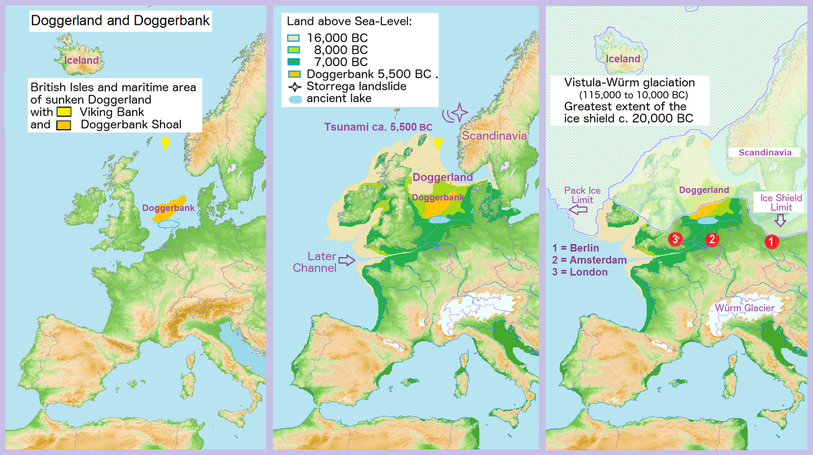
Between Britain and the Netherlands there is a landscape with rivers, lakes and hills, mapped in detail, that no one has ever seen. It held people for thousands of years and the sea took it. The part everyone knows, that a tsunami finished it off, is the part the researchers who mapped it now question.
There is a country under the North Sea. Not a metaphor and not a legend: a real landscape of river valleys, lakes, hills, salt marsh and coastline, lying under water between eastern England and the Netherlands, which has been mapped in enough detail to trace individual river channels across it. People lived there. Nobody alive has ever seen it, nobody has excavated a house on it, and the sea covered it so long ago that the covering is itself prehistory.
The name is Doggerland, after the Dogger Bank, the shallow rise that was the last part of it above water. What makes it worth an article is not the drowning, which is well understood, but the two things sitting on either side of the drowning: how anyone came to know the shape of a landscape nobody can visit, and what actually happened to the people on it at the end. The second question has moved recently, and it has moved away from the version you have probably heard.
01The Land That Was There
During the Last Glacial Maximum, roughly 26,500 to 19,000 years ago, enough of the world's water was locked in ice that global sea level stood something like 120 to 130 metres below today's. The southern North Sea basin was dry. Exposed land ran from the present English coast across to the Netherlands, Germany, Denmark and towards Norway. The ancestral Thames, Rhine, Meuse and Elbe did not run into a sea there because there was no sea there; they joined and ran on, out through what is now the English Channel. The bathymetry of the modern North Sea still shows their valleys under the sediment.
Our research file puts Doggerland's maximum extent at roughly 18,000 square kilometres and notes that estimates run higher depending on which sea-level threshold you choose. That last clause is doing real work and this page keeps it: the area of a landscape defined by where the water stopped is a function of where you decide the water stopped, so the figure is a choice as much as a measurement. No external source was resolved for the 18,000 figure for this article, so treat it as our file's number rather than a settled one.
02What Comes Up In The Nets
Almost everything physical we have from Doggerland was recovered by people who were not looking for it. Trawler nets, dredging and targeted underwater work have brought up mammoth bone, antler and other Pleistocene fauna from the Dogger Bank and Brown Bank areas, along with Mesolithic flint including a handaxe found by a trawler in 1931, and human cranial fragments from the Dogger Bank. The most famous single find is a barbed antler point dredged from the Leman and Ower Bank at about 25 metres depth; our file dates it to around 11,740 years before present. That is a strange kind of archaeology: a site you cannot visit, sampled at random by an industry with no interest in it.
The accidental phase is ending. Missiaen and colleagues, publishing in Quaternary International in 2021, describe an interdisciplinary campaign targeting the Brown Bank area specifically, combining survey and sampling to go after Mesolithic material rather than wait for it to surface in a net. The author list is led by Tine Missiaen and includes Simon Fitch, Merle Muru and Vince Gaffney, the same people behind the landscape mapping below. The point of the work is the transition it represents: from a landscape known through what fell out of trawlers to one being searched on purpose.
03Reading A Landscape Nobody Can See
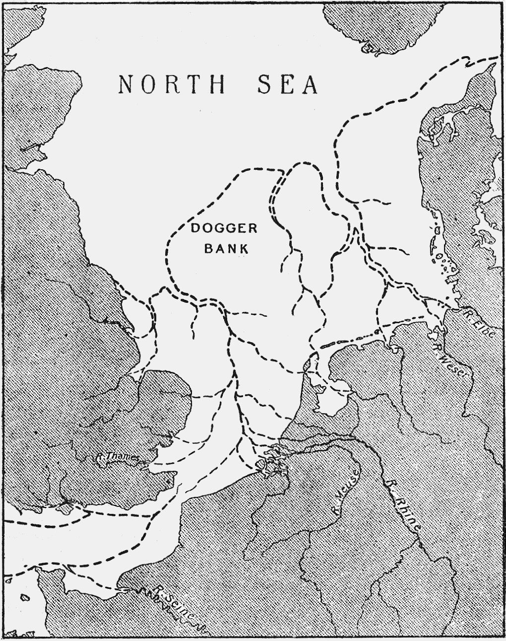
Bryony Coles published Doggerland: a Speculative Survey in the Proceedings of the Prehistoric Society in 1998. The title is honest about its method. Working largely from what was known of sea level and the shape of the sea floor, she argued that the submerged North Sea should be treated as a landscape in its own right rather than as a gap between two coastlines, and she gave it the name. The evidence to test that came afterwards, which is worth noticing: the idea that there was a country down there was an argument before it was a map.
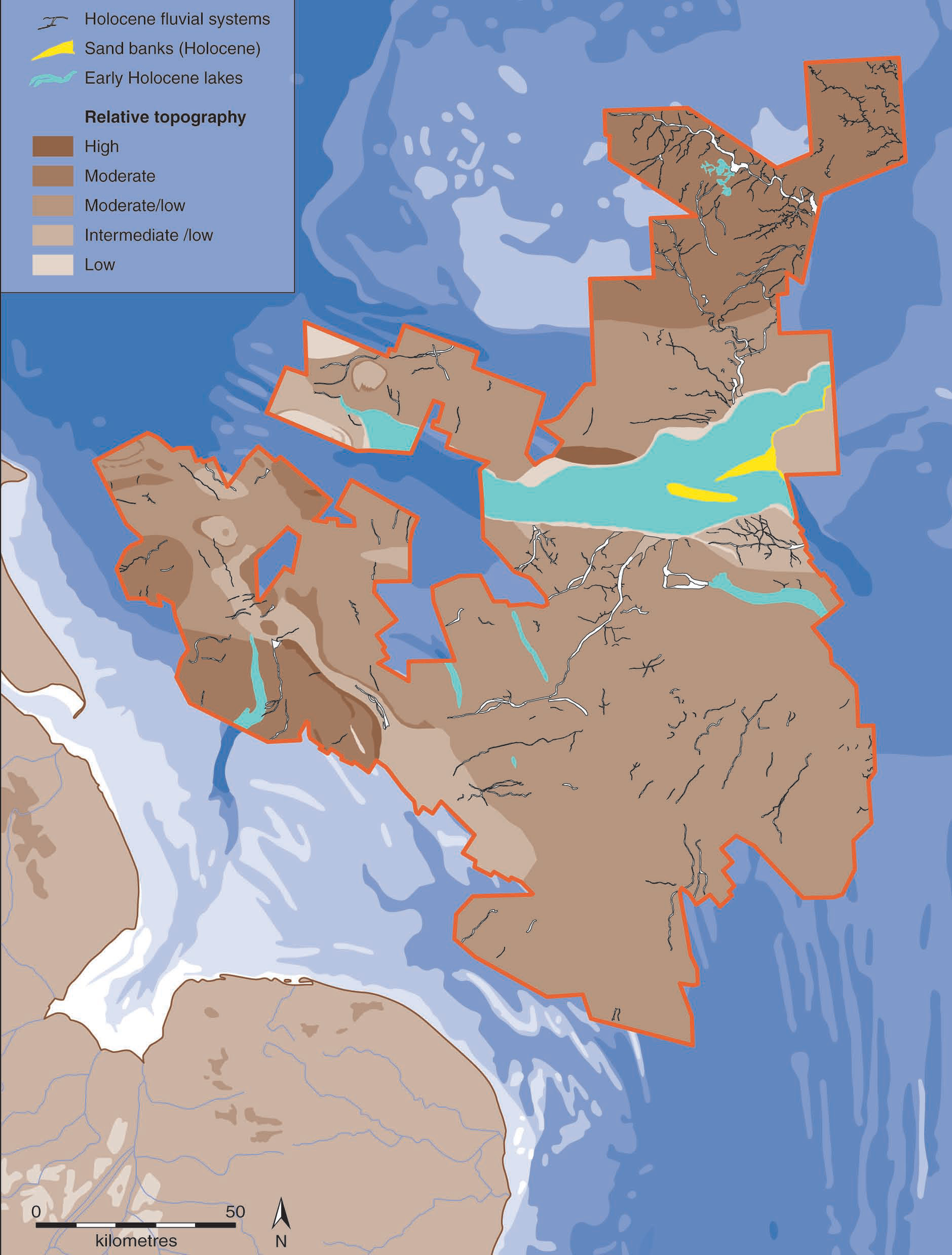
The reconstruction that followed used data nobody had collected for archaeology. Seismic reflection surveys, shot across the North Sea by oil and gas exploration, image the layers beneath the sea floor, and those layers include the buried surface of Doggerland. Vince Gaffney and colleagues turned that material into landscape: river systems, lake basins, salt marsh, coastline and hills, published as Europe's Lost World in 2009 and extended by the Europe's Lost Frontiers project. It is an unusual chain of custody for evidence. The maps exist because somebody was looking for hydrocarbons.
The most recent phase reads the ground itself. Allaby and colleagues, in the Europe's Lost Frontiers volume published in 2022, describe reconstructing the palaeoenvironment of the North Sea landscape from sedimentary ancient DNA: genetic material left in the sediment by the plants and animals that lived there, recovered from cores drilled into the sea floor. Where seismic gives you the shape of the land, this gives you what was growing and moving on it, from a core taken through the water column into a surface that has been buried for eight thousand years.
| The Method | What It Establishes | What It Cannot Do |
|---|---|---|
| Trawled and dredged finds | That people and animals were there. Mammoth bone, antler, worked flint, a barbed antler point from the Leman and Ower Bank, human cranial fragments from the Dogger Bank | Give a context. An object in a net has lost its position, its stratigraphy and its association with anything else. It proves presence and almost nothing further |
| Seismic reflection survey | The shape of the buried landscape at large scale: river channels, lake basins, coastlines, relative topography across whole survey blocks | Resolve a site. Our own file puts the resolution at roughly 5 to 10 metres horizontally and about a metre vertically, which is far too coarse for a house, a hearth or a burial |
| Sediment coring and sedimentary ancient DNA | What was actually living there. Pollen, plant remains and genetic material recovered directly from the buried surface | Cover much ground. A core is a straw through a landscape, and the sampling is expensive and logistically hard in the North Sea |
| Tsunami deposit stratigraphy | That the Storegga wave reached a given place, and how high. Sand layers within coastal peat at named sites in Scotland, Norway, the Faroes and Shetland | Say what it did to anyone. A sand layer records water arriving; it does not record who was standing there or whether they came back |
Coles's proposal was not simply that the land existed but that it mattered. She argued Doggerland was a Mesolithic heartland rather than a marginal edge: the most productive and most densely populated part of northwestern Europe in the Early Mesolithic, before the sea took it back. The reasoning is about the mix. Rivers, estuaries, lakes and coast packed into one compact region give exceptional resource diversity, and our file compares it to the richest Mesolithic landscapes known on dry land. Under that reading, the map of Mesolithic Europe that everyone learns is missing its middle, and what survives on land is the periphery.
04The Wave
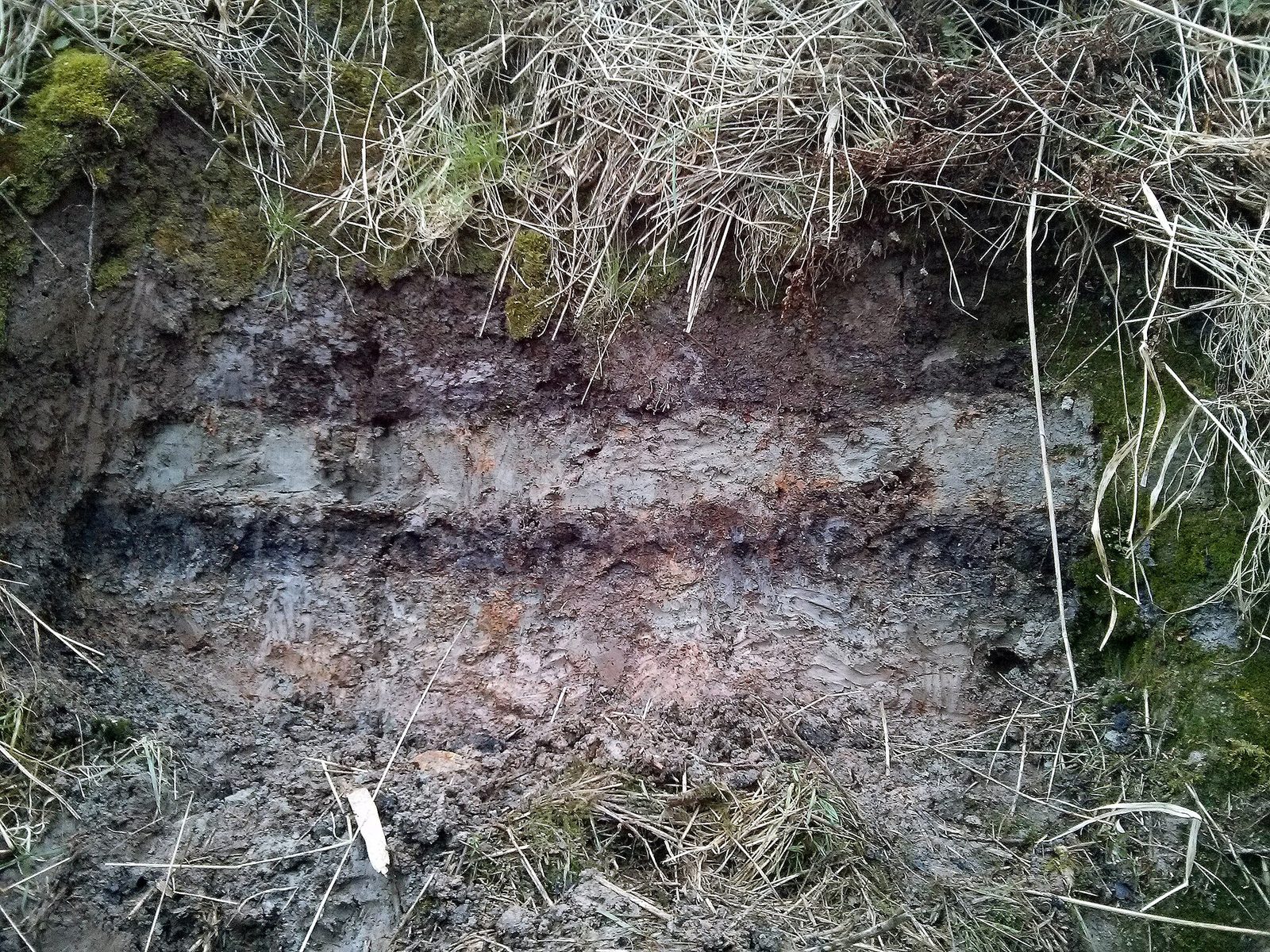
Around 8,150 years ago a vast piece of the continental slope off western Norway gave way. The Storegga Slide sent sediment down into the deep and generated a tsunami across the northern North Sea. The evidence is physical and it is on land: sand layers deposited within coastal peat sequences, found in Scotland, Norway, the Faroe Islands and Shetland. Stein Bondevik and colleagues compared those field observations against numerical simulations of the wave in Marine and Petroleum Geology in 2005, which is the kind of test that turns a deposit into a modelled event. Our own file gives the slide volume as about 3,500 cubic kilometres and run-up in Scotland as up to about 25 metres; no external source was resolved for either figure here, so both are carried as our file's.
The standard telling follows immediately. By around 8,200 years ago rising seas had already reduced Doggerland to low islands. Then the wave arrived and finished it, drowning the last inhabitants or driving them off, and Britain became an island. Bernhard Weninger and colleagues put that case in Documenta Praehistorica in 2008 under a title that states it plainly: the catastrophic final flooding of Doggerland by the Storegga Slide tsunami. Our own research file reproduces this version. It is a good story, the mechanism is real, and the most recent work by the people who mapped the landscape does not accept its conclusion.
05And Whether It Ended Anything
James Walker, Vincent Gaffney, Simon Fitch, Merle Muru, Andrew Fraser, Martin Bates and Richard Bates published A great wave: the Storegga tsunami and the end of Doggerland? in Antiquity in 2020. The question mark is the argument. In the paper's own words: the size of this wave has led many to assume that it had a devastating impact upon contemporaneous Mesolithic communities, including the final inundation of Doggerland. They present the first evidence of the tsunami from the southern North Sea, and suggest that traditional notions of a catastrophically destructive event may need rethinking, offering instead a more nuanced interpretation that incorporates the role of local topographic variation.
Local topographic variation is a dry phrase for something concrete. A tsunami is not a uniform wall arriving everywhere at once; what it does at a given place depends on the shape of that place, on the depth offshore, the gradient of the shore, the direction the water is coming from and what is in the way. A landscape of islands, channels and shallows does not experience one wave. It experiences many different local events, some devastating and some survivable, and the difference between those is geography rather than the size of the slide.
Notice what has and has not changed. The slide happened. The tsunami happened. The deposits are real and datable and this page does not soften any of that. What is in question is the inference laid on top: that a big wave necessarily means an extinction event for the people in its path, and that the wave is the reason Doggerland ended. Sea level was rising throughout, and had been for thousands of years, which is a slower and less dramatic explanation that was already sufficient. It is worth being honest that the catastrophe reading is also the more tellable one, and that this is exactly the condition under which a claim gets repeated past its evidence.
The undramatic mechanism is well modelled. Fraser Sturt, Duncan Garrow and Sarah Bradley published new models of North West European Holocene palaeogeography and inundation in the Journal of Archaeological Science in 2013, reconstructing how the coastlines of this region actually moved through the Holocene. Against that background the loss of Doggerland is a process rather than an event: land becoming marsh, marsh becoming shallows, a plain becoming an archipelago becoming a bank, across thousands of years, at a rate a person might notice across a lifetime but could not have fought.
06What It Is Not
Some popular writing identifies Doggerland with Plato's Atlantis, and our own research file marks the claim debunked. The refusal is not a matter of taste. The chronology does not work: Doggerland was flooded between roughly 8,000 and 6,000 BCE, which is thousands of years off Plato's timeline. Nor does the description: Doggerland was a Mesolithic hunter-gatherer landscape, and Plato's Atlantis is a Bronze Age maritime state with ships, metal, walls and a navy. The temptation is understandable, since here at last is a real drowned country, but a real drowned country is a poor fit for a story about a different kind of place at a different time. This library treats Atlantis in its own article in this wing.
07What Is Still Not Known
The largest hole in the subject is the simplest to state. Seismic data show mound-like features that might be preserved settlement sites, middens or house platforms, and none has been excavated underwater. Preservation is genuinely uncertain: the North Sea floor is a high-energy environment subject to tidal scour, and eight thousand years of that is a long time for anything delicate. So the strongest statements about how Doggerland's people lived rest on analogy with contemporaries who lived on land, and analogy is not a site.
It is often suggested that the drowning, and Storegga in particular, lies behind European flood myths. Our own file carries the idea and says plainly that a direct connection between any specific myth and this event cannot be demonstrated, which is the right handling. Eight thousand years is a very long chain of transmission with no writing at either end for most of it, and flood stories appear in places that had no Doggerland. Interesting, unprovable, and this page leaves it there.
Our file records the argument, associated with Clive Waddington, that displaced Doggerland populations moved both east into the Netherlands and Scandinavia and west into Britain, and that the final flooding episodes are visible in changes in the British Mesolithic record: new technologies and practices arriving with people who had lost their land. Carried at our file's strength. It is an inference from cultural change to population movement, which is a move archaeology has learned to make carefully, and this page does not upgrade it.
Fast Facts
- What It Was
- A real landscape of rivers, lakes, marsh and hills under the southern North Sea, connecting Britain to continental Europe. Named after the Dogger Bank, the last part of it above water
- Why It Was Dry
- At the Last Glacial Maximum, roughly 26,500 to 19,000 years ago, sea level stood about 120 to 130 metres lower. The Thames, Rhine, Meuse and Elbe joined and ran out through what is now the Channel
- Who Named It
- Bryony Coles, in Doggerland: a Speculative Survey, Proceedings of the Prehistoric Society, 1998. The argument came before the map
- How It Was Mapped
- Seismic reflection surveys shot by the oil and gas industry, reworked into landscape by Vince Gaffney and colleagues. Published as Europe's Lost World in 2009 and extended by Europe's Lost Frontiers
- What Comes Up
- Mammoth bone, antler, Mesolithic flint including a 1931 trawled handaxe, human cranial fragments from the Dogger Bank, and a barbed antler point from the Leman and Ower Bank at about 25 metres depth
- The Storegga Slide
- About 8,150 years ago, off western Norway. Tsunami sand layers within coastal peat in Scotland, Norway, the Faroes and Shetland. Bondevik and colleagues tested the field evidence against numerical models in 2005
- The Correction
- Walker, Gaffney, Fitch, Muru, Fraser, Bates and Bates, Antiquity 2020, present the first evidence of the tsunami from the southern North Sea and argue that the catastrophically-destructive reading may need rethinking, because local topography changes what a wave does
- What Nobody Has Done
- Excavated a settlement. Seismic shows mound-like features that may be sites; none has been dug, and the sea floor is a high-energy environment
- Not Atlantis
- Wrong millennium and wrong kind of society. Our own file marks the identification debunked
What We Can Actually Stand Behind
The North Sea basin was dry land during the Last Glacial Maximum and the ancestral Thames, Rhine, Meuse and Elbe ran through it. Artefacts and fauna have been recovered from the sea floor, including worked flint, antler, mammoth bone and human cranial fragments. Bryony Coles named and argued for the landscape in 1998. Vince Gaffney and colleagues reconstructed it from oil-industry seismic data and published it in 2009. The Storegga Slide occurred around 8,150 years ago and its tsunami left dated sand deposits in coastal peat across Scotland, Norway, the Faroes and Shetland. Walker and colleagues published the first evidence of that tsunami from the southern North Sea in 2020.
That Doggerland was a Mesolithic heartland rather than a margin, which is Coles's argument and rests on resource diversity rather than on excavated population evidence. That the tsunami was or was not decisive for the people living there: Weninger and colleagues argue catastrophic final flooding in 2008, and Walker, Gaffney and colleagues argue in 2020 that this needs rethinking and that local topography governs the outcome. And that displaced populations are visible in changes in the British Mesolithic, which is an inference from culture to migration.
Whether any of the mound-like features in the seismic data are preserved settlement sites, since none has been excavated and the preservation environment is hostile. Whether the drowning lies behind European flood myths, which our own file says cannot be demonstrated and which this page does not assert. And the size of the population that lived there at any time, which no line of evidence currently constrains well.
Doggerland was not Atlantis. The chronology is thousands of years wrong and the society is the wrong kind: a Mesolithic hunter-gatherer landscape is not a Bronze Age maritime power. And no source on this page establishes that the Storegga tsunami killed the last inhabitants of Doggerland. That claim circulates widely, our own file carries a version of it, and the most recent paper from the team that mapped the landscape explicitly questions it.
What makes this one worth sitting with is the direction the correction ran. Doggerland reached the public as a catastrophe: a country under the sea and a wave that ended it, which is a story shaped like a story. The people who did most to put it in front of the public are the same people now saying the wave probably did not do what the telling requires, on the strength of the first tsunami evidence from the southern part of the basin. That is not a reversal and it is not embarrassing. It is what it looks like when evidence arrives after a narrative has already formed, and somebody chooses the evidence.
Sources & further reading
WHERE THIS WORKED FROM, AND WHERE IT CAN BE CHECKED. This article was written from one file in our own research library, F_4_25, which is where it worked from rather than where it can be checked. The eight external entries below are what stands behind the claims, and every identifier here was resolved live against Crossref for this article with the returned title read against the work it is attached to. TWO IDENTIFIERS CARRIED BY OUR OWN FILE RESOLVE TO BOOK REVIEWS RATHER THAN TO THE BOOKS, and neither is reproduced below. The DOI our file attaches to Gaffney, Fitch and Smith's Europe's Lost World resolves to a 2010 review of that book by Geoff Bailey in Cambridge Archaeological Journal; the book is therefore cited here by an ISBN verified against Open Library. A second DOI in circulation for Mapping Doggerland is likewise a review, by Richard Bates in Archaeological Prospection. This is the third article in this run to find a corpus identifier pointing at a review of a work rather than the work, and it is worth naming as a pattern rather than an accident. WHERE THIS PAGE DEPARTS FROM OUR OWN FILE. The file states that the Storegga tsunami was the final catastrophic event and would have devastated the remaining Doggerland islands and their inhabitants. The most recent major treatment, by the team that mapped the landscape, argues that this reading may need rethinking. Both are on the page, attributed, and the page does not decide between them beyond noting which is more recent and who wrote it. WHAT IS CARRIED AS OUR FILE'S OWN NUMBER AND NOT AS A SETTLED ONE. The 18,000 square kilometre area, which the file itself says varies with the sea-level threshold chosen; the Storegga volume of about 3,500 cubic kilometres; the run-up of up to about 25 metres in Scotland; the date of about 11,740 years before present for the Leman and Ower antler point; and the seismic resolution figures of roughly 5 to 10 metres horizontally and about a metre vertically. No external source was resolved for any of those five during this article's research, and each is attributed to the file in the text rather than stated flat.
Image credits
- A three-panel map of Doggerland showing its extent, its progressive inundation and the ice-age context Francis Lima, via Wikimedia Commons. CC BY-SA 4.0 Source.
- Clement Reid's early twentieth-century map of the Dogger Bank and the drowned river courses of the North Sea Clement Reid, via Wikimedia Commons. Public domain Source.
- Early Holocene landscape features of the southern North Sea mapped by the North Sea Palaeolandscapes Project GaffersMiddle, via Wikimedia Commons. CC BY-SA 4.0 Source.
- Storegga tsunami deposits exposed in section at Montrose basin, Maryton, Scotland Stozy10, via Wikimedia Commons. CC BY-SA 3.0 Source.


.jpg)