
Ciudad Perdida: The City Found by Following a Staircase
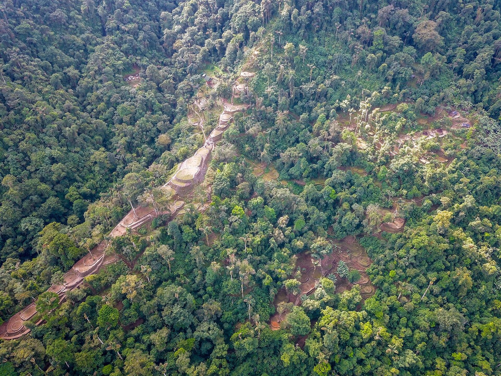
Looters found it in 1972 by walking up stone steps that came out of the jungle floor. It had been there since about 800 CE, a hundred and sixty-nine terraces cut into a Colombian mountainside, and the argument about what kind of society built it stopped being a theory argument in 2025 and became a measurement.
The find story is the best thing about this site and it is almost never told straight. In 1972, treasure hunters working the Buritaca River drainage in northern Colombia came across stone steps going up out of the forest floor. They followed them. At the top, under a canopy that had closed over it completely, was a city.
Not a ruin in a clearing. Not a monument anyone had been maintaining. A hundred and sixty-nine stone terraces cut into a mountainside at thirteen hundred metres, with stairways and roads and drainage canals between them, grown over so completely that it went unrecorded until treasure hunters walked into it. It is called Ciudad Perdida in Spanish and Teyuna by the people whose ancestors built it, and this page is about what is actually known, which turns out to include a live argument that has just changed character.
01What Is Actually There
Ciudad Perdida sits at approximately 1,300 metres on the northern slope of the Sierra Nevada de Santa Marta, reached by a four to six day trek from the nearest road. Our research file gives the site as covering roughly 13 hectares with 169 stone terraces cut into the mountainside, linked by stone stairways, roads and drainage canals. Those figures are our file's and were not externally verified for this article.
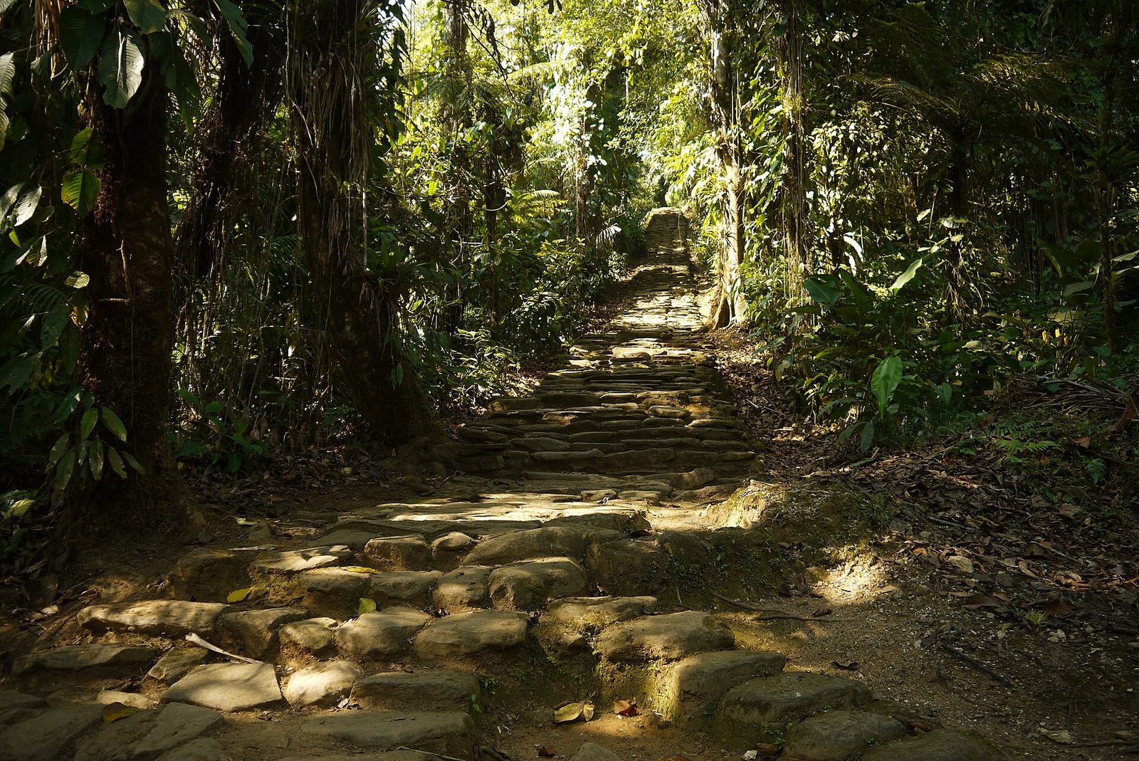
The site was found in 1972 by local treasure hunters, guaqueros, who followed stone staircases up the Buritaca River drainage. Radiocarbon dating of charcoal from basal terrace fills places initial construction at approximately 800 CE, with peak occupation between 1000 and 1550 CE. Our file adds a comparison worth carrying as its own: that this puts Ciudad Perdida roughly 650 years earlier than Machu Picchu.
Our research file names two different excavation teams for the same 1976 start, two paragraphs apart. Its summary says the site was excavated by Álvaro Soto Holguín and Gilberto Cadavid. Its verified-claims section says systematic work began under Gilberto Cadavid and Luisa Fernanda Herrera of the Instituto Colombiano de Antropología e Historia. Cadavid is in both; the second name is not the same person. No external source was resolved for this article to settle it, so this page does not settle it. Cadavid led or co-led; who worked alongside him is, in our own documentation, two different answers.
02The Engineering, And The Gold
Our file records Tairona terraces at Ciudad Perdida and at over 250 other documented terrace sites in the Sierra Nevada incorporating stone-lined channels that direct rainwater away from living surfaces, against annual rainfall exceeding 3,500 millimetres. It cites Augusto Oyuela-Caycedo documenting road networks connecting settlements across multiple ecological zones, from coastal estuaries to summits above 3,000 metres, with roads paved in stone slabs up to four metres wide, retaining walls, and bridges across ravines. Read that as an economy rather than a road: a network spanning that much vertical range is moving different things at different altitudes.
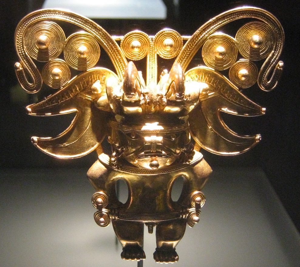
Tairona metalwork is primarily tumbaga, a gold-copper alloy. Our file gives the Museo del Oro in Bogotá as holding over 2,500 Tairona gold objects, including pectorals, nose ornaments, lip plugs and pendants depicting bats, jaguars and human-animal transformations, cast by the lost-wax method, and records Carl Henrik Langebaek documenting depletion gilding, the surface enrichment of gold on a tumbaga alloy. The pendant beside this claim was checked independently against its own museum record, and it is what our file describes: Museo del Oro, tumbaga, Tairona, from the Sierra Nevada.
03The Argument That Stopped Being Theoretical
Here is the part of this subject that has genuinely moved, and it is the reason this page exists rather than a summary of the trek. For about twenty-five years the central question about Tairona society has been argued as a problem in anthropological categories. Since 2025 it has been getting answered with survey data, and the answer is not what either side was arguing for.
Our file records Oyuela-Caycedo challenging the description of Tairona society as a chiefdom, on the grounds that chiefdom is a hierarchical category inherited from neo-evolutionary anthropology, and arguing instead for a heterarchical model: multiple competing centres sharing power without a single paramount authority, supported by the diversity of ceramic styles and architectural plans across terrace sites. It records Langebaek countering that settlement size hierarchies and the uneven distribution of goldwork indicate genuine rank differentiation. Our file's own conclusion is that the debate reflects tensions about applying Western political typologies to societies whose organizational logic may not map onto them.
In 2025 Luis Miguel Soto Rodríguez and Juan Carlos Vargas published a network analysis in the Journal of Archaeological Science, modelling social interaction and economic integration from the technological and typological attributes of ceramic assemblages across pre-Hispanic settlements in a 40 square kilometre area of the Río Frío basin. Their reported findings, in their own words: the results reveal varying degrees of economic integration among settlements, with certain sites playing central roles in the distribution of ceramic goods and coordination of economic activities; different degrees of interaction and socioeconomic integration by occupation period are detected; and the centrality of certain settlements suggests different scales of intermediation in economic interaction through time.
A companion 2025 paper by the same authors in the Journal of Field Archaeology investigates how conflict shaped socio-political organization and demographic centralization in the same basin between the tenth and sixteenth centuries CE. It examines the Pocigüeica chiefdom, which its abstract describes as a political entity recognised for its belligerent character and warrior chiefs with segmented decision-making structures, which resisted Spanish conquest in the sixteenth century. Segmented is the operative word, and it does not sit comfortably on either side of the old argument.
| Position | What It Rests On | Where It Stands |
|---|---|---|
| Chiefdom with rank differentiation (Langebaek) | Settlement size hierarchies and the uneven distribution of goldwork, as our own file reports them | Partly supported: certain settlements do turn out to be central in the 2025 network analysis |
| Heterarchy, multiple competing centres (Oyuela-Caycedo) | Diversity of ceramic styles and architectural plans across terrace sites, and a critique of the chiefdom category itself | Partly supported: the 2025 conflict paper describes warrior chiefs with segmented decision-making structures |
| Network analysis of ceramics, 2025 | Technological and typological attributes of assemblages across 40 square kilometres of the Río Frío basin | Finds VARYING degrees of integration, and different scales of intermediation THROUGH TIME. Not one answer, a changing one |
| Conflict and centralization, 2025 | European chronicles plus geostatistical and multivariate analysis of settlement patterns | States plainly that archaeology had not previously examined conflict against political leadership and social organization here |
| The programme is ongoing | A regional-scale survey and reconnaissance programme, described in the 2025 papers as currently ongoing, with further results published in 2026 | This page reports what has been published and read. It does not project where the programme ends up |
Two further papers from the same programme appeared in 2026: Centralization and Integration in Tairona Chiefdoms of the Río Frío basin, in the Journal of Archaeological Research, and Late Holocene niche construction and carrying capacity in Tairona chiefdoms of the Río Frío Basin, in Anthropocene. Both are named here because they exist and are current. No abstract for either was obtainable while writing this page, so nothing is claimed about what they found. A reader who wants the state of the question in a year should start with those two rather than with this page.
04A Century Of Holding Out
Our file records first European contact by Rodrigo de Bastidas in 1525, coordinated Tairona uprisings in 1599 and 1600 that burned Spanish settlements and killed colonists, and a punitive campaign under Governor Juan Guiral Velón from 1599 to 1602 that burned villages, destroyed crops and enslaved captives. By the 1650s, on our file's account, surviving populations had retreated to higher and more remote elevations, where their descendants, the Kogi, Arhuaco, Wiwa and Kankuamo, live today. The reason this sits at Tier 2 rather than Tier 1 is the source base: it comes from Spanish colonial archives, which is to say from the administrative record of the people conducting the campaign. That is real evidence and it is also one side's paperwork.
05How Many People, And Why Nobody Can Say
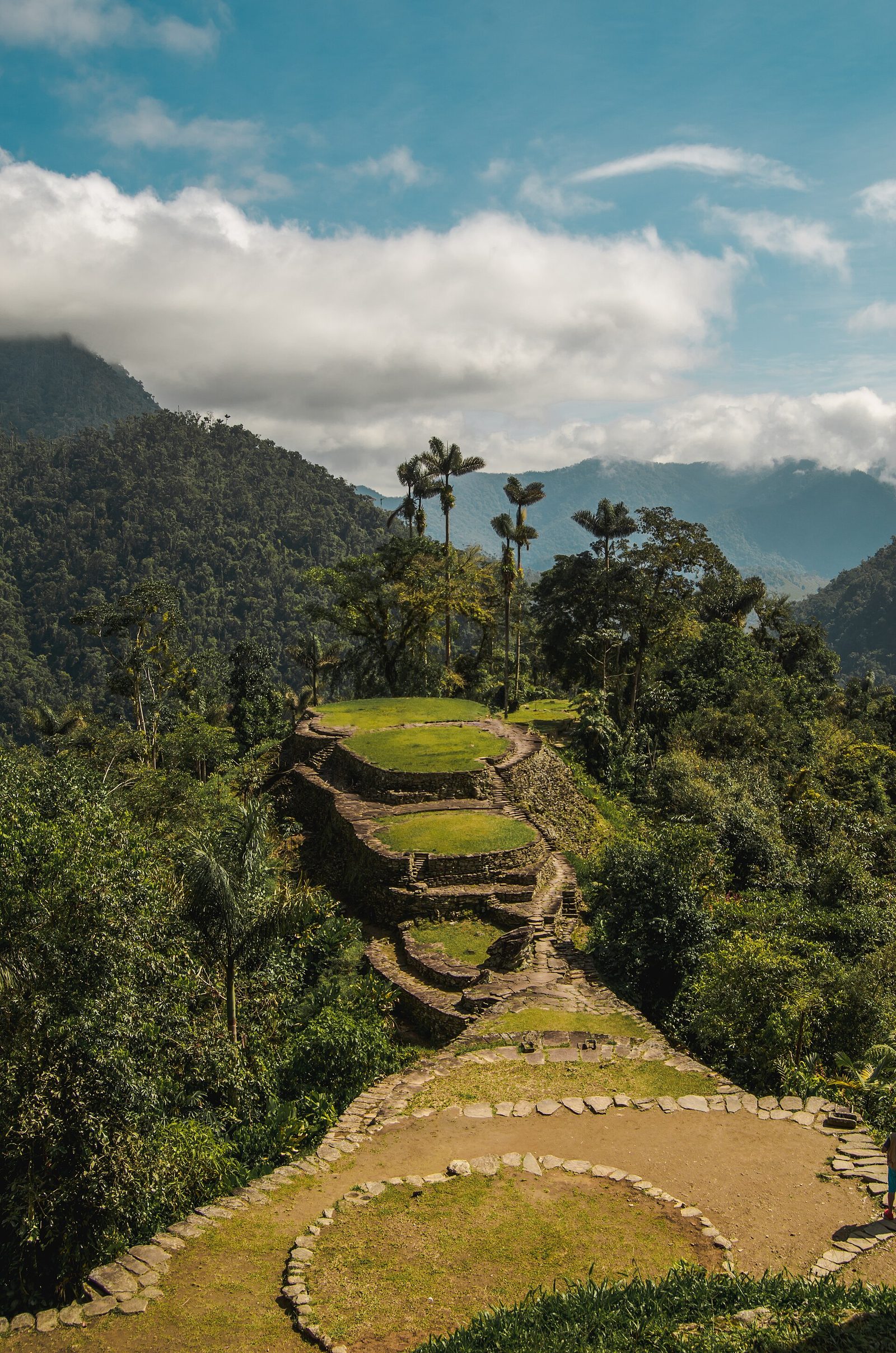
Our file gives Langebaek's pre-contact Tairona population estimate as 250,000 to 500,000, from settlement density surveys identifying over 250 terrace sites, and puts Ciudad Perdida itself at 2,000 to 8,000 people at its peak. Its own counter-argument is the honest part: estimates vary enormously because surveying dense tropical forest is extremely difficult, and some are as low as 100,000. The low figure and the high figure differ by a factor of five. When a page quotes you a population for a pre-Columbian society, that spread is usually what is underneath the number you were given.
06The People Who Are Still There
The Kogi, living above 2,000 metres in the Sierra Nevada, claim direct descent from the Tairona and maintain oral traditions describing Ciudad Perdida as a sacred ancestral city. Our file cites Gerardo Reichel-Dolmatoff documenting that Kogi Mámas, priests, preserve cosmological knowledge through initiatory training lasting nine to eighteen years in darkness. What our file explicitly leaves open is narrower than it first sounds: not whether the Kogi are descendants, but whether specific Kogi oral accounts constitute reliable historical memory of specific Tairona events. Its own counter-argument is that traditions carried across four hundred years and more inevitably transform, and that separating historical content from later elaboration requires corroboration from outside the tradition.
07What It Is Not
Claims that Ciudad Perdida evidences a lost advanced global civilization are refused, and our own file marks them debunked. Tairona civilization developed locally within the Chibchan cultural sphere of northern South America, with regional influences from Mesoamerica and lower Central America, and its material culture, architecture and subsistence patterns are consistent with indigenous South American developmental trajectories. It is worth naming what the lost-civilization framing actually costs here. Ciudad Perdida is impressive because people who lived on that mountain worked out how to hold a flat surface against three and a half metres of annual rain. Attributing it elsewhere does not add mystery. It removes the engineers.
| When | What | How It Is Known |
|---|---|---|
| c. 800 CE | Initial construction of the terraces | Radiocarbon dating of charcoal from basal terrace fills, per our file |
| 1000 to 1550 CE | Peak occupation | Per our file, from the same dating programme |
| 1525 | First European contact, by Rodrigo de Bastidas | Colonial record, per our file |
| 1599 to 1600 | Coordinated Tairona uprisings burn Spanish settlements | Colonial record, per our file |
| 1599 to 1602 | Punitive campaign under Governor Juan Guiral Velón | Colonial record, per our file |
| By the 1650s | Retreat to higher, more remote elevations | Per our file. The descendant peoples are still there |
| 1972 | Found by guaqueros following stone staircases up the Buritaca drainage | Per our file |
| 1976 | Systematic archaeological work begins | Per our file, WHICH NAMES TWO DIFFERENT TEAMS in two places. See the first section of this page |
| 2025 to 2026 | Río Frío basin programme publishes network, conflict, centralization and carrying-capacity studies | Resolved and read for this article, except the two 2026 papers, whose abstracts were unavailable |
Fast Facts
- The Names
- Ciudad Perdida in Spanish, the lost city. Teyuna to the descendant peoples of the Sierra Nevada
- Where
- Northern slope of the Sierra Nevada de Santa Marta, Colombia, at about 1,300 m. A four to six day trek from the nearest road, per our file
- The Scale
- About 13 hectares, 169 stone terraces, with stairways, roads and drainage canals. Our file's figures
- Built
- From about 800 CE, peak occupation 1000 to 1550 CE, by radiocarbon on charcoal in basal terrace fills
- Found
- 1972, by guaqueros who followed stone staircases up the Buritaca River drainage
- Excavated
- From 1976. Our own file names Cadavid in both of its accounts and a DIFFERENT second archaeologist in each
- The Rain
- Over 3,500 mm a year, which is what the stone-lined drainage channels exist to handle
- The Reach
- Over 250 terrace sites documented in the Sierra Nevada, on roads of stone slabs up to 4 m wide, from coastal estuaries to above 3,000 m
- The Gold
- Tumbaga, a gold-copper alloy, lost-wax cast, with depletion gilding. Over 2,500 Tairona objects in the Museo del Oro, per our file
- Who Is There Now
- The Kogi, Arhuaco, Wiwa and Kankuamo, descendants who did not leave the Sierra Nevada
What We Can Actually Stand Behind
The site exists, at roughly 1,300 m in the Sierra Nevada de Santa Marta, and was found in 1972 by treasure hunters following stone staircases. Radiocarbon on basal terrace fills places construction from about 800 CE. Tairona metalwork is tumbaga, lost-wax cast, and the Museo del Oro holds it; the pendant on this page was verified independently against its own museum record. Soto Rodríguez and Vargas published a ceramic network analysis of the Río Frío basin in the Journal of Archaeological Science in 2025 and a conflict-and-centralization study in the Journal of Field Archaeology in 2025, and two further papers from the programme appeared in 2026. Mason's 1931 Field Museum report on the Tairona is real and freely readable.
Whether Tairona society is better described as a ranked chiefdom or a heterarchy of competing centres. The 2025 results support pieces of both and describe integration that varies by settlement and by period, which is a third kind of answer rather than a win for either. The population figures, where our own file's high and low estimates differ by a factor of five. And the resistance narrative, which is well documented and documented by the Spanish administration.
Whether specific Kogi oral accounts preserve reliable historical memory of specific Tairona events. Our own file holds this open and gives the reason: four centuries of transmission, and no external corroboration for the specific claims. The descent itself is not what is in question.
Ciudad Perdida is not evidence of a lost advanced global civilization. Its material culture, architecture and subsistence sit inside the Chibchan sphere of northern South America. And this page does not resolve who worked with Cadavid in 1976, because our own documentation gives two different answers and this article did not find a source that settles it.
What stays with me is how ordinary the disappearance was. Nobody hid this city. There was no cataclysm at the end of it, no ash layer, no wave. There was a punitive campaign, a retreat uphill, and then four centuries of rain and seed and root doing what rain and seed and root do at three and a half metres a year. The stairs stayed exactly where they had been laid. They were just under something. And when somebody finally walked up them, it took another four years before anyone with a trowel arrived, and our own record of who that was disagrees with itself.
Sources & further reading
WHERE THIS WORKED FROM, AND WHERE IT CAN BE CHECKED. This article worked from one file in our own research library, W_5_28, which carries a Source Confidence of 2 out of 5. It earns that. EVERY DOI IN ITS BIBLIOGRAPHY WAS RESOLVED LIVE AGAINST CROSSREF FOR THIS ARTICLE, AND ALL FIVE POINT AT A DIFFERENT WORK. The identifier given for Reichel-Dolmatoff's 1965 book returns Warwick Bray's 1966 review of it in Antiquity. The identifier given for Reichel-Dolmatoff's 1976 chapter on Kogi priesthood returns a 1982 review of a different book, about the Warao of Venezuela, which survives a casual check only because both volumes share an editor and a publisher. The identifier given for Langebaek's 2005 monograph on the Santa Marta bays returns a 2020 paper on Neolithic settlement in Serbia. The identifier given for Oyuela-Caycedo's 1998 Cambridge Archaeological Journal article returns Steven Mithen's 1997 review essay on the evolution of language, in the right journal and nothing else right. And the identifier given for Bray's 2003 World Archaeology paper returns a 2004 article on early medieval fish weirs in Irish estuaries. NONE OF THEM SHIPPED. Every external source listed below was found independently, by searching Crossref and OpenAlex directly, and resolved before being cited. ONE THING WENT THE OTHER WAY. Our file's entry for Mason's 1931 Field Museum report carries no identifier at all, mangles the author to 'Mason, J' and leaves his middle name stranded in the publisher column. The report is John Alden Mason's, it is real, and it is freely readable through the Biodiversity Heritage Library. That identifier is recovered here. WHAT IS CARRIED AS OUR FILE'S OWN, UNVERIFIED HERE. The elevation, the 13 hectares, the 169 terraces, the radiocarbon dates, the 250-plus terrace sites, the 3,500 mm rainfall, the 4 m road slabs, the 2,500 Museo del Oro objects, the population ranges, the conquest chronology, the 9 to 18 year Máma training, and the comparison with Machu Picchu. Each is attributed in the text where it appears. WHERE THIS PAGE DEPARTS FROM OUR FILE. W_5_28 presents the chiefdom-versus-heterarchy question as a standoff between two readings and its most recent source is a 2010 dissertation. Since 2025 the Río Frío basin programme has been putting settlement, ceramic and spatial data to the same question. This page reports what those papers state, quotes them where the wording matters, and crowns neither side, because they do not. A NOTE ON THE CROSS-REFERENCES. W_5_28's own header links to W_5_29 under the label 'Muisca Confederation El Dorado'; the file it points at is San Agustín Archaeological Park. Routed to corpus hygiene with the five identifiers.
Image credits
- Ciudad Perdida (Teyuna) from the air, Sierra Nevada de Santa Marta, Colombia Garth.bruce, via Wikimedia Commons. CC BY-SA 4.0 Source.
- Terraces and stone retaining walls at Ciudad Perdida Giancarlos1234, via Wikimedia Commons. CC BY-SA 4.0 Source.
- Stone staircase through forest at Ciudad Perdida Uhkabu, via Wikimedia Commons. CC BY-SA 3.0 Source.
- Tairona tumbaga pendant, Museo del Oro, Bogota Brunosan, via Wikimedia Commons. CC BY 2.5 Source.


