
Atlantis: The Lost World That Started Them All
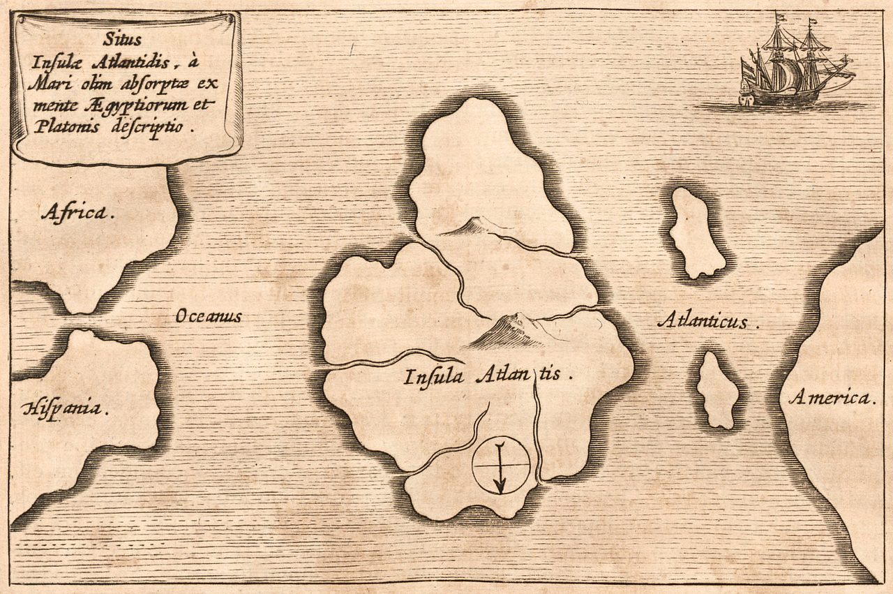
Two dialogues, one of them unfinished. Around 360 BCE Plato wrote the Timaeus and the Critias, and in them an Egyptian priest at Sais tells the Athenian statesman Solon about an island empire beyond the Pillars of Heracles, larger than Libya and Asia combined, swallowed by the sea in a single day and night some 9,000 years before Solon's own visit. Then the Critias stops mid-sentence and never resumes. For something close to 2,400 years, readers have been trying to find that island on a real map: in the Sahara, in the Aegean, under Antarctic ice, off a beach in the Bahamas. This article is about the text and about the search. What Plato actually wrote, where the hunt has gone, what it has genuinely turned up, the one candidate it has closed for good, and where mainstream classical scholarship now sits on whether there was ever anything to find. Here is the file, opened claim by claim, each one wearing its evidence.
The Atlantis story starts in two documents, and the same man wrote both of them. Plato's Timaeus and Critias, composed around 360 BCE, are where the island comes from, and the second of the two never finished: the Critias breaks off in the middle of a sentence, with Zeus calling the gods into council to decide what to do about the place. Everything downstream of that broken sentence, every expedition, every map, every documentary, every claim that a sunken empire is waiting to be found, is an attempt to attach a real location to a description in an unfinished dialogue. So this article does not open with where Atlantis is. It opens with what the text says, moves to who has gone looking and where, and ends with an honest accounting of what close to 2,400 years of looking has actually produced. Let's open the file.
01What Plato Actually Wrote
Plato's Timaeus and Critias both exist, both were written around 360 BCE, and both say what they are quoted as saying. The Timaeus introduces Atlantis with a compressed history and an account of its destruction. The Critias then supplies the detail: geography, architecture, culture, laws. It is unfinished, and it breaks off mid-sentence. Our own file's reliability matrix rates this specific claim at its highest mark, five out of five in its own matrix, and it deliberately keeps that rating separate from a completely different question, which is whether any of the content is historically accurate.
The dialogue supplies its own chain of custody, and it should be read as exactly that: a claim the text makes about itself. Egyptian priests at Sais tell the story to Solon, the Athenian statesman, whose visit to Egypt our file places at around 600 BCE. Solon passes it to Dropides, Dropides to Critias the Elder, Critias the Elder to Critias the Younger, and Critias the Younger is the character who tells it inside Plato's dialogue, written around 360 BCE. The events themselves are placed roughly 9,000 years before Solon's visit, which puts the destruction at approximately 9,600 BCE. That the text says all this is verified. That the chain actually held is a separate question, and this article does not let the two borrow each other's confidence.
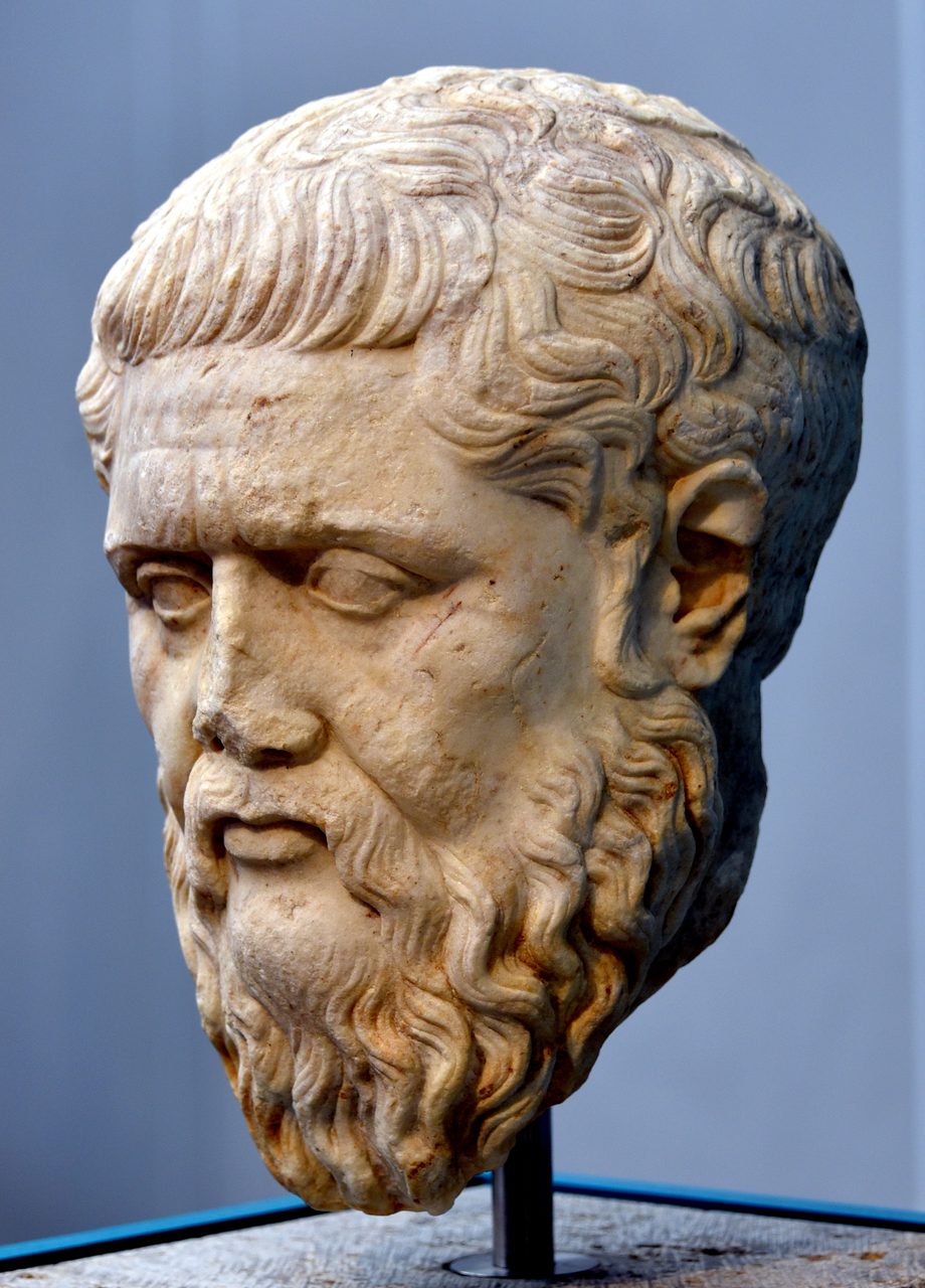
Notice the shape of that chain before going any further. From Solon's visit to Plato's writing is roughly 240 years, crossed by four named men: Solon, Dropides, Critias the Elder, and Critias the Younger. And the events themselves are placed 9,000 years before the first of those four ever heard about them. Whatever else turns out to be true of the Atlantis account, no part of it is a contemporary record, and the text does not pretend otherwise. It tells you plainly that it is a story about a story about a story.
| Link | As the Text Has It |
|---|---|
| The Events | Placed roughly 9,000 years before Solon's visit, which puts them at approximately 9,600 BCE |
| Egyptian Priests At Sais | Tell the story to Solon |
| Solon | Athenian statesman; our file places his Egypt visit at around 600 BCE |
| Dropides | Receives the account from Solon |
| Critias the Elder | Receives it from Dropides |
| Critias the Younger | The character who tells it inside Plato's dialogue, and Plato's stated source |
| Plato | Writes the Timaeus and the Critias around 360 BCE; the Critias is left unfinished |
02The Island, As the Text Describes It
Two stretches of summary follow, and they need a label attached before they start. Everything in them is Tier 1 in one specific sense: this is what the dialogues say, and anyone can check it against the Greek. None of it is Tier 1 in the sense that matters most to a reader, which is whether any of it happened. Our own file splits those two questions and rates the second one Tier 2 to 3. This article holds the same split all the way through, and section 12 is where the second question gets its hearing.
Here is what the Egyptian priest tells Solon in the Timaeus. Athens once existed as a great civilization around 9,600 BCE. Beyond the Pillars of Heracles, which is the Strait of Gibraltar, lay Atlantis, an island the text calls larger than Libya and Asia combined. From Atlantis a traveler could reach other islands, and from those islands the opposite continent that surrounds the true ocean. Atlantean kings ruled the island plus parts of Libya as far as Egypt and parts of Europe as far as Tyrrhenia. Atlantis launched an invasion; Athens alone resisted it and defeated it. Then came extraordinary earthquakes and floods, and the island was swallowed up by the sea and vanished in a single day and night. Afterward, the text says, the sea there became impassable, blocked by shoals of mud.
The Critias is where the detail arrives, and the detail is the reason this story has never been left alone. A circular central island ringed by three rings of water and two rings of land, the central island about 5 stadia across, roughly 925 meters, joined to the sea by a canal. A temple to Poseidon one stadion long, sheathed in silver with gold pinnacles, holding a gold statue of the god in a chariot drawn by six winged horses and attended by 100 Nereids on dolphins. Construction in red, white, and black stone. Bridges between the rings and tunnels cut through for triremes. Abundant resources, including elephants. Orichalcum, a metal the text places second only to gold, sheathing the walls of the inner citadel. Ten kings descended from Poseidon, their laws inscribed on an orichalcum pillar. Ten thousand chariots, 1,200 ships, hundreds of thousands of troops. A subtropical climate yielding two harvests a year. And then a moral decline, as the founders' divine blood thinned across the generations into greed and imperialism. The last thing the Critias does before it stops is convene the gods: Zeus calls a council to decide the island's punishment, and the sentence never finishes.
| Feature | As the Text Gives It |
|---|---|
| Position | Beyond the Pillars of Heracles, the Strait of Gibraltar; larger than Libya and Asia combined |
| Layout | A circular central island inside three rings of water and two rings of land, joined to the sea by a canal |
| Central Island | About 5 stadia across, roughly 925 meters |
| Temple To Poseidon | One stadion long, silver-clad with gold pinnacles; a gold statue of the god in a six-horse chariot with 100 Nereids on dolphins |
| Building Stone | Red, white, and black, with bridges between the rings and tunnels cut for triremes |
| The Metal | Orichalcum, second only to gold, sheathing the inner citadel walls |
| Government | 10 kings descended from Poseidon, their laws inscribed on an orichalcum pillar |
| Military | 10,000 chariots, 1,200 ships, hundreds of thousands of troops |
| Climate | Subtropical, with two harvests a year |
| The Ending | Extraordinary earthquakes and floods; swallowed by the sea in a single day and night; the sea afterward impassable, blocked by shoals of mud |
That table is the whole argument in miniature, and it cuts both ways at once. Our file's own list of reasons to think Plato was working from something real makes much of the detail: a moral lesson about hubris does not require bridge dimensions, ring diameters, and troop counts. Our file's own list of reasons to think he invented it makes just as much of the same detail from the other side: the account is too neat, the rings too perfect, the numbers too precise to be anybody's memory of anything. Both readings are looking at the identical page. Section 12 lays them out properly.
03The Ocean Beyond the Ocean
A single passage in the Timaeus has done more work in the modern Atlantis literature than any other, and it belongs at the tier our file actually gives it. The text says that from Atlantis a traveler could reach other islands, and from those islands the opposite continent that surrounds the true ocean. Read one way, the other islands are the Caribbean, the Azores, or the Canaries; the opposite continent is the Americas; and the true ocean is the Pacific, since the Americas together with Asia and Australia do in fact ring the Pacific. If that reading is correct, then a Greek writing around 360 BCE, drawing on Egyptian sources, was describing the geography of the Western Hemisphere, and our file cross-references its own document on early cartography at exactly this point. If the reading is wrong, the passage is mythic geography and nothing more. Our file offers it as one possible reading. It does not claim it as an identification, and neither does this article.
04Before Plato, and After Him
Plato was not the first Greek to put a splendid island out in the western ocean. Homer, around the 8th century BCE, describes the Phaeacians, advanced seafarers living on the island of Scheria with supernatural ships and a claim of divine ancestry. Hesiod, also around the 8th century BCE, describes the Isles of the Blessed, out in that same western ocean. And Egyptian records refer to Western Lands and to the Hau-Nebut, the people of the islands. Our file presents these as parallels, not as earlier drafts. What they establish is that the shape of the story, a rich people on an island out past the edge of the known map, was already available to a Greek audience before Plato reached for it.
After Plato, the ancient record is thin and it argues with itself. Aristotle, Plato's own student, writing around 340 BCE, is widely quoted as saying of Atlantis that he who invented it, also destroyed it, which would settle his opinion neatly if the quotation were solid; our own file flags that this specific quote is poorly attested, and this article carries the flag rather than the quote. Crantor, around 300 BCE, the first commentator on the Timaeus, claimed to have checked the account personally with Egyptian priests at Sais, who he said showed him columns with the story inscribed on them. Proclus, in the 5th century CE, is the source that reports Crantor's verification visit. And Diodorus Siculus, in the 1st century BCE, describes a people he calls the Atlantioi, of the Atlas mountain region, who were invaded by the Amazons.
05The Date That Will Not Sit Still
Plato's destruction date, approximately 9,600 BCE, lands inside a window no Greek could have known about. The Younger Dryas, a sharp return to cold conditions, runs roughly 12,800 to 11,600 years before present, and its termination around 9,700 to 9,500 BCE brought massive meltwater pulses and catastrophic flooding. Construction at Gobekli Tepe begins around 9,500 BCE. The Younger Dryas was not identified as a climate event until the 20th century, so Plato cannot have engineered the alignment deliberately. During this article's research pass the date was checked against our own Younger Dryas file, which carries its own comparison table listing Plato's Atlantis destruction at roughly 11,600 years ago, sitting at the very end boundary of the same window. The two files agree; no contradiction was found between them.
An alignment is not a mechanism, and this is the point in the article where it is cheapest to forget that. Plato's number sits at the closing edge of a real global climate event, which is genuinely striking. It is not evidence that a specific city drowned in that event, and nothing in our file claims it is. What the alignment does explain is why the search never dies. If the date had pointed at a quiet millennium, Atlantis would be a curiosity in a philosophy syllabus. It points instead at a real interval of meltwater pulses and catastrophic flooding, at almost exactly the moment organized construction begins at Gobekli Tepe, so people keep going out to look.
| What | When | Why It Is On This List |
|---|---|---|
| Plato's Atlantis Destruction | Approximately 9,600 BCE, roughly 11,600 years ago | Given in the Timaeus as about 9,000 years before Solon's visit to Egypt |
| The Younger Dryas | Roughly 12,800 to 11,600 years before present | A real cold interval; Plato's date sits at its end boundary |
| Younger Dryas Termination | Around 9,700 to 9,500 BCE | Massive meltwater pulses and catastrophic flooding |
| Gobekli Tepe, Construction Begins | Around 9,500 BCE | An organized, capable culture is on the ground close to Plato's date |
| The Thera Eruption | Circa 1600 BCE | The date of the leading Mediterranean candidate, roughly 8,000 years later than Plato's |
The modern search has a starting gun, and it is a book. Ignatius Donnelly's Atlantis: The Antediluvian World, published in 1882, is the work that revived popular interest in Atlantis, and the candidates in the next four sections are what a century and a half of that revived interest has produced. Each one is a real place. Each one is a proposal. Our file's own reliability matrix rates the Richat, Antarctica, Sundaland, and Gunung Padang identifications at Tier 3, along with the lost-network synthesis in section 11, and it notes that of the sources it surveys, none endorses any identification definitively.
06The Eye of the Sahara
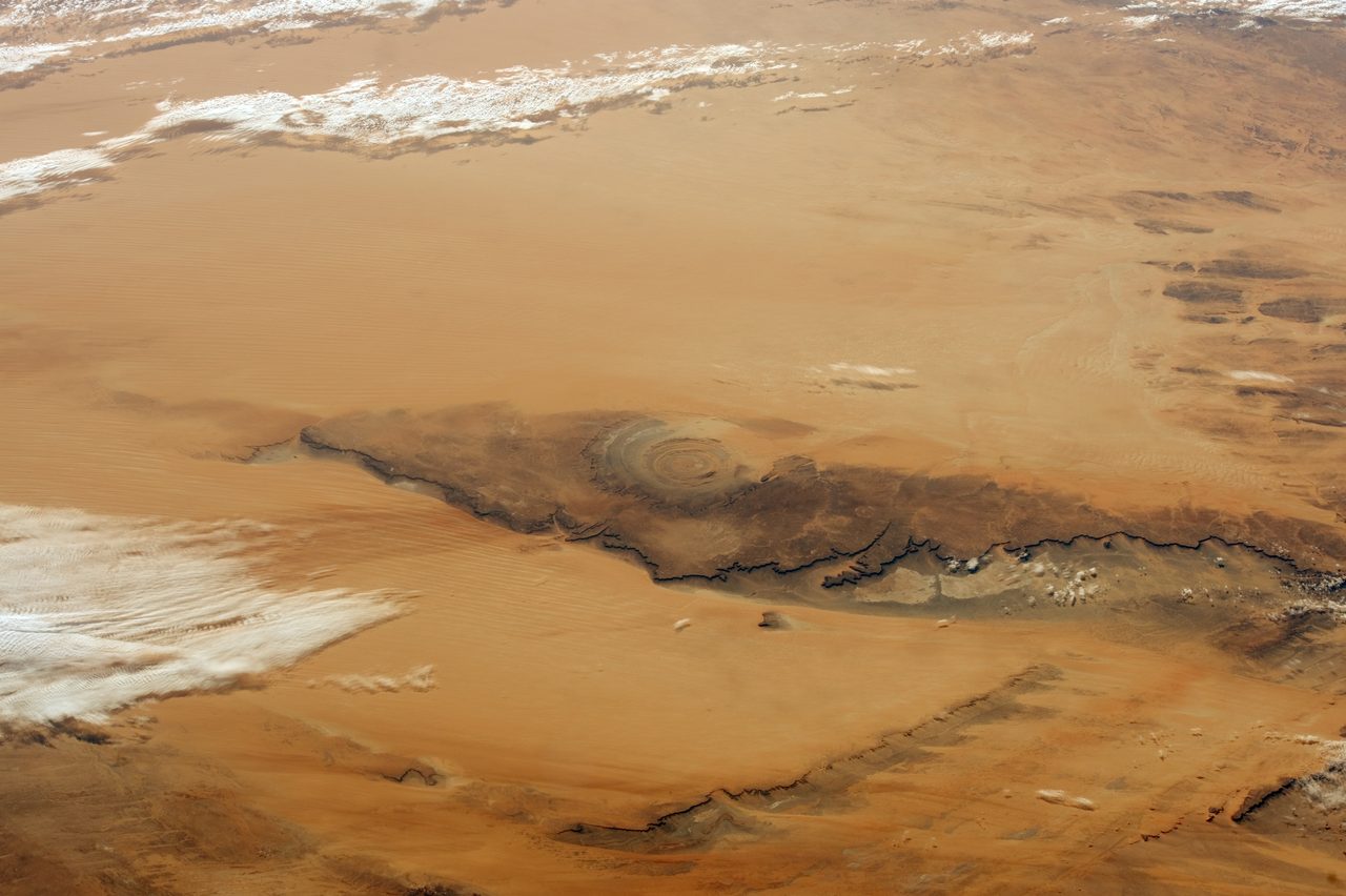
The Richat Structure sits on the Adrar Plateau in Mauritania, in the Sahara Desert, and it is a genuinely remarkable object. Concentric rings visible from space, an outer diameter of roughly 40 to 50 kilometers, an inner ring measuring approximately 23.5 kilometers. It is not an impact crater. Geologists read it as a deeply eroded domed anticline, roughly 100 million years old, and the rings, the diameters, and that age are not in dispute. Satellite radar has separately confirmed a massive ancient paleo-river system that once flowed across the Sahara and emptied into the Atlantic near the Richat, which could have created an estuary or an island environment when sea levels stood higher, and salt deposits in the soil are consistent with, though not proof of, former marine submersion.
That paleo-river deserves its real name and its real paper, because our own file gets both of them wrong. Our file cites the source as Skopos, J. E. and colleagues, Origins of the Tamrasett River, in Nature Communications. During this article's research pass that citation was checked through CrossRef and web search, and no such author and no such paper exists. The real work is Skonieczny and thirteen colleagues, African humid periods triggered the reactivation of a large river system in Western Sahara, published in Nature Communications volume 6 as article 8751 in 2015, with the title and the full 14-author list independently confirmed. What it describes is a buried paleoriver valley called the Tamanrasett, found in Japanese satellite microwave and radar data, winding more than 500 kilometers from the Atlas Mountains toward the Atlantic, with a drainage basin larger than the present-day Ganges and Brahmaputra basin, reactivating as a flowing river during African humid periods and most recently active roughly 11,700 to 5,000 years ago. If it ran today it would rank among the largest rivers on Earth. The corrected citation is linked at the foot of this article. The error was in our file's citation, not in the science.
The identification is a different animal from the measurements, and our file rates it a tier lower. The Richat-as-Atlantis case was popularized by Jimmy Corsetti on the YouTube channel Bright Insight, and its centerpiece is a number: the inner ring measures approximately 23.5 kilometers, and Plato's stated 127 stadia works out to about 23.5 kilometers at a 185-meter stadion, which proponents call a perfect match. The problems our file lists are as plain as the match is neat. The site sits in the desert today, not underwater. There is no archaeological evidence of a city there. Geologists looking at the rings see natural erosion, not canals anyone dug. Proponents answer that the Sahara was green during the African humid period, that the ice-age Atlantic coastline lay closer, that the paleo-river provided ocean access, and that Plato's measurements may refer only to the inner rings. Every one of those answers is possible. None of them is a city.
One thing is worth noticing while that number is still in front of us. The Critias gives the central island as about 5 stadia across, roughly 925 meters, so the 127 stadia being matched here is a different and far larger measurement from the same description. A match between one number and one ring is not a match between a description and a place. That is not a knockout argument against the Richat proposal. It is a reminder of how much of the description is still unmatched once the striking coincidence has been admired.
And one more overlap belongs here, stated plainly and then left alone. The Tamanrasett's most recent active window, roughly 11,700 to 5,000 years ago, does contain Plato's date of approximately 11,600 years ago. That is a real overlap between two numbers in this article. It is not an identification of anything. A river flowing across the Western Sahara at the end of the last ice age is a fact about the Sahara. It becomes a fact about Atlantis only if somebody finds Atlantis.
07The Volcano
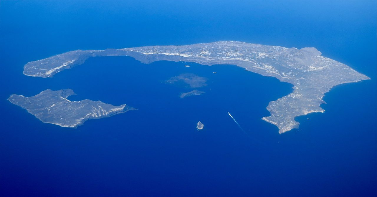
The best known modern candidate is the Aegean. The Thera eruption, around 1600 BCE, struck a blow at an advanced Minoan maritime civilization, and the volcano left behind a circular flooded caldera that looks a great deal like a harbor. Galanopoulos proposed the identification in 1969 and it has never gone away. Our own file then lists four objections, and they are not small. Wrong location: the Mediterranean, not the Atlantic beyond Gibraltar. Wrong date: 1600 BCE, not 9,600 BCE, a gap of roughly 8,000 years. Wrong size: Atlantis as described is far larger. And the text is explicit that Atlantis lies beyond the Pillars of Heracles, which is to say not in the Mediterranean at all. The Tier 2 rating here attaches to the proposal being a serious and long-standing one. It does not attach to the identification being correct.
Two things need separating here, because this wing will come back to both of them. The Minoans were a real, advanced maritime civilization, and the Thera eruption was real and catastrophic. That civilization gets its own article in Lost Worlds, told on its own terms rather than as somebody's answer to a Greek riddle. What sits in this article is only the proposal that Plato was writing about them. The same applies to Tartessos, which has also been proposed as a candidate location and which also has its own article coming here. A real civilization is not diminished by being a poor fit for a philosopher's island, and it is not confirmed by being a good one.
08Four More Places On the Map
Antarctica. Rand and Rose Flem-Ath argued the case in When the Sky Fell in 1995, building on Charles Hapgood's crustal displacement mechanism, set out in his Maps of the Ancient Sea Kings in 1966. The supporting parallels drawn are old maps that some read as showing an ice-free Antarctica, and the sheer size of the continent set against the size Plato claims. The problems our file names are structural rather than incidental. Crustal displacement is rejected by mainstream geology. And the Antarctic ice sheet is roughly 34 million years old, though our file notes that some coastal areas may have been ice-free more recently.
Sundaland. The submerged continental shelf spanning Indonesia, Malaysia, and the Philippines was genuinely a vast, inhabitable landmass during the last ice age, when sea levels stood roughly 120 meters lower, and its drowning by post-glacial sea-level rise represents the largest loss of land in the human era. That part is not in dispute. The Atlantis identification, argued by Arysio Nunes dos Santos and by Stephen Oppenheimer, runs into one flat obstacle that our file states without softening it: the direction is wrong. Plato specifies beyond the Pillars of Heracles, which means west, into the Atlantic, not east or southeast toward Southeast Asia.
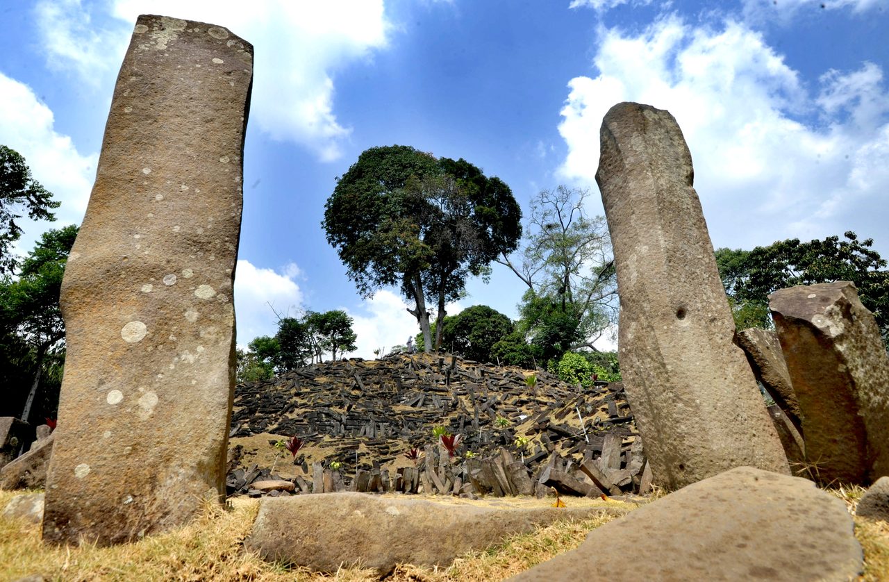
Gunung Padang, in West Java, Indonesia, is a real megalithic site, and its upper layers are genuinely megalithic and genuinely old, dating to roughly 5,000 to 2,000 BCE. In 2023 a paper by Danny Hilman Natawidjaja and colleagues in Archaeological Prospection reported that deep layers at the site carbon-dated to between 25,000 and 14,000 BCE, which would make it the world's oldest pyramid, and some proponents connected that result to Sundaland as a supposed Atlantean outpost. Mainstream archaeologists countered that the deep layers are more likely natural lava and soil formations, and that the carbon dating may be measuring natural organic matter in the soil rather than anything anyone built. The journal opened an investigation into the paper's peer-review process, and the paper was retracted in 2024. The retraction notice cites misattributed radiocarbon dating of natural soil organics, insufficient evidence for artificial construction at the deep layers, and irregularities in the peer-review process. That retraction was verified through CrossRef during this article's research pass and is linked below.
What remains of the Gunung Padang claim after 2024 is a proposal without a published paper standing behind it. The deep-layer dates are the retracted part; the upper terraces are not, and running the two together is the standard error in popular coverage of the site. It is also worth saying that a retraction is not the same thing as a disproof. It means the paper as published did not carry the weight of its claim, which is a real and serious finding about the paper, and it returns the underlying question to roughly where it stood before the paper appeared.
| Candidate | The Case For It | Tier, and Where It Actually Stands |
|---|---|---|
| The Richat Structure, Mauritania | Concentric rings roughly 40 to 50 km across, an inner ring of approximately 23.5 km set against Plato's 127 stadia, a confirmed ancient paleo-river reaching the Atlantic nearby, and salt deposits consistent with former marine submersion | Tier 3, speculative, for the identification. The rings themselves are real and natural, a deeply eroded domed anticline about 100 million years old; the site is inland desert today and carries no archaeological evidence of a city |
| Santorini and Minoan Crete | The Thera eruption around 1600 BCE destroyed an advanced maritime civilization, and the caldera resembles a harbor. Proposed by Galanopoulos, 1969 | Tier 2 as a serious, long-standing proposal, not as an answer. Our file's own four objections: wrong location, wrong date by roughly 8,000 years, wrong size, and Plato places Atlantis beyond the Pillars of Heracles |
| Antarctica | Hapgood's crustal displacement; old maps that some read as showing an ice-free continent; the size of the continent against the size claimed. Argued by Rand and Rose Flem-Ath, 1995 | Tier 3, speculative. Crustal displacement is rejected by mainstream geology, and the ice sheet is roughly 34 million years old, though some coastal areas may have been ice-free more recently |
| Sundaland | A genuinely vast inhabitable landmass drowned by post-glacial sea-level rise, with ice-age sea levels roughly 120 m lower. Argued by Arysio Nunes dos Santos and Stephen Oppenheimer | Tier 3, speculative. The drowned continent is real; the identification is the wrong direction from Egypt, since Plato specifies beyond the Pillars of Heracles |
| Gunung Padang, West Java | A 2023 paper reported deep layers dating to 25,000 to 14,000 BCE, which some connected to Sundaland as an Atlantean outpost | Tier 3, and formally retracted in 2024 for misattributed dating, insufficient evidence of artificial construction, and peer-review irregularities. The upper megalithic terraces, roughly 5,000 to 2,000 BCE, are verified and are not the retracted part |
| The Bimini Road, Bahamas | Submerged limestone blocks off North Bimini, found in 1968, claimed as an Atlantean road or wall | Tier 4, no. Natural beachrock fracturing along cleavage planes; cores show sedimentary layering matching ocean-floor orientation; associated shells date to 2,000 to 4,000 years before present |
| Doggerland, North Sea | A real drowned inhabited landmass of up to roughly 260,000 sq km, home to Mesolithic hunter-gatherers from about 10,000 to 6,500 BCE | Tier 1 as a drowned world, and our file calls its Atlantis connection weak: wrong location, wrong period. It is on this list as proof that lost lands are ordinary, not as a candidate |
09The One Claim That Is Closed
In 1968 divers found a line of submerged limestone blocks off North Bimini in the Bahamas, and the blocks were claimed as an Atlantean road or wall. They are neither. Geological analysis, with Eugene Shinn's fieldwork central to it, identifies the blocks as beachrock, a natural sedimentary rock that fractures along cleavage planes into shapes that look laid rather than broken. Core samples show sedimentary layering oriented to match the ocean floor, not the quarrying or intentional placement human construction would leave behind. And radiocarbon dating of associated shells returns 2,000 to 4,000 years before present, which misses a 9,600 BCE date, roughly 11,600 years ago, by more than seven thousand years even at the most generous end. Our file's verdict is that the formation is natural and geological, and the Nature paper on the site, Harrison's Atlantis Undiscovered: Bimini, Bahamas, from 1971, is linked below.
No, the Bimini Road is not an artificial road, wall, or harbor works built by anyone, Atlantean or otherwise. This is not an open question being held politely open. The rock has been cored, the cores have been read, the shells have been dated, and the answer came back natural. It is worth marking clearly, because in an article where almost everything else sits at Tier 2 or Tier 3, this is the one place where evidence actually closed a door.
10The Drowned Land That Is Actually There
Doggerland lies under the North Sea, in the basin between Britain, the Netherlands, Denmark, and Norway. At its maximum extent it reached up to roughly 260,000 square kilometers, which is larger than Great Britain. Mesolithic hunter-gatherers lived on it from around 10,000 to 6,500 BCE, and the archaeological evidence for them is rich: tools, animal bones, human remains. Post-glacial sea-level rise drowned it gradually, and the final inundation was likely accelerated by the Storegga Slide around 6200 BCE, a massive undersea landslide off Norway that generated tsunami waves reaching as high as 25 meters. Fishing trawlers still regularly bring up Mesolithic artifacts, mammoth bones, and human remains from the North Sea floor. Our file's source for it is Gaffney and colleagues, Europe's Lost World: The Rediscovery of Doggerland, 2009.
Our own file is explicit that Doggerland's direct connection to Plato's Atlantis is weak: the wrong location and the wrong time period for what the Timaeus describes. It is in the file for a different and more useful reason. Doggerland is a verified instance of exactly the thing the Atlantis story is about, a populated land the sea took, and it establishes that such places are geologically ordinary rather than extraordinary. That is genuinely important context and it is not an argument for Atlantis. It is an argument that people who suspect there are drowned inhabited landscapes out there are correct, that we have found some of them, and that none of the ones we have found is Plato's island. Doggerland has its own article coming in this wing, told properly and at length. What it is doing here is setting a baseline.
11One Atlantis, or Many
The Network Hypothesis proposes that Atlantis was never one place at all. On this reading the name is shorthand for a network of related maritime civilizations, all of them destroyed by the same Younger Dryas catastrophe. The evidence cited for it is global flood traditions found worldwide, precession-of-the-equinoxes numbers claimed to be identical across multiple continents, and construction techniques claimed to be shared across widely separated ancient sites. Graham Hancock and Randall Carlson are the proponents our file names.
Hancock's fuller version, laid out in Fingerprints of the Gods in 1995 and Magicians of the Gods in 2015, runs like this. A technologically sophisticated maritime civilization existed during the last ice age. It mapped coastlines, built megalithic structures, encoded knowledge of the precession of the equinoxes, and navigated the oceans. The Younger Dryas catastrophe destroyed it, roughly 12,800 to 11,600 years before present, through cosmic impact, mega-flooding, and rapid climate change. Survivors dispersed and became the knowledge-giver figures who turn up in culture after culture: Oannes and the Apkallu in Sumer, Thoth in Egypt, Viracocha in South America, Quetzalcoatl in Mesoamerica, the Seven Rishis in India. Atlantis, in this reading, is simply Plato's name for that lost network, and what survived of its knowledge survived encoded in myth, architecture, and number systems. Our file rates this Tier 3 and so does this article: a synthesis that is argued rather than demonstrated.
Our file supports that synthesis with a table of cross-references to its own documents, and the table is worth looking at carefully, because it demonstrates a common way an argument can look stronger than it is. The cited supports are that the Younger Dryas catastrophe was real, that Gobekli Tepe proves a sophisticated culture existed around 9,500 BCE, that over 500 flood narratives exist worldwide, that certain ancient maps show geographic knowledge some call impossible, that some megalithic engineering exceeds conventional explanation, that trans-oceanic contact left evidence, and that the civilization-bringer figure is culturally universal. Some of those items are solidly established: the Younger Dryas happened, and Gobekli Tepe is real and old. Others are themselves contested claims wearing the clothes of evidence, which is exactly the work the words impossible and exceeds conventional explanation are doing in that list. During this article's research pass all seven of the cross-referenced documents were independently confirmed to exist as real files in our library. That is a fact about our own housekeeping and nothing more; a working cross-reference is not a working argument. A pile of true things is not a demonstration until something ties them together, and the tie is precisely the part that is missing.
12Did Plato Make It Up
This is the question the whole article has been walking toward, and our file handles it better than it handles anything else. Section 5 of F_4_01 runs the case for fiction as a set of arguments each answered by a counter, then runs the case for a historical kernel as its own list, and never crowns a winner. That evenhandedness is a virtue, and it is also, in one specific respect, a gap. This section closes the gap.
First, the dialogue is a teaching device, and Atlantis functions as a moral lesson about hubris. The counter our file offers is that a moral lesson does not require that much specific geographic, architectural, and numerical detail. Second, there is no independent corroboration. The counter is that Crantor claimed verification at Sais and that other ancient sources do reference western islands. Third, the account is too neat: perfect rings, precise numbers, a description too clean to be anyone's record of anything. The counter is that Egyptian architecture was itself highly geometric, so the regularity might reflect real design rather than invention. Fourth, Aristotle reportedly dismissed it as invented. The counter is that the quotation is poorly attested and may be apocryphal.
The other side of our file's ledger runs to six points. The narrator explicitly calls the account true history, rendered in our file as it is not a myth but a true account, from Timaeus 26e. The level of specific detail, measurements and ring dimensions and military numbers and construction materials, is excessive for a pure allegory. The 9,600 BCE date aligns with a real catastrophe Plato could not have engineered deliberately. An Egyptian source is plausible, since Egypt preserved records for millennia and Solon's visit is historically attested. The opposite-continent passage, arguably describing the Americas, is an odd detail to invent for a moral fable. And the Critias breaking off mid-sentence is an unusual fate for what would have been a planned, finished piece of fiction.
Our file presents both sides evenly and never states which reading the field actually holds, so this article states it. Current mainstream academic consensus among classical scholars is that Atlantis is most likely Plato's own literary invention: an allegory constructed to make a philosophical argument, aimed at refuting Herodotus-style claims about Egyptian antiquity and knowledge, and at moving readers toward the ideals laid out in the Republic. Plato's own student Aristotle is reported to have doubted it was real, which is consistent with our file's own note even though that specific quotation is poorly attested. This is flagged for what it is: a synthesis of how current classical scholarship is broadly characterized, drawn from multiple secondary sources during this article's research pass, rather than a single named peer-reviewed paper. And it is narrower than it sounds. What remains genuinely contested among classicists is not whether Atlantis existed as described. It is whether Plato drew on any real historical or geographic material as raw ingredients for the story he built.
Our file's academic shelf on exactly this question is three books, and it is a good shelf: Pierre Vidal-Naquet's The Atlantis Story: A Short History of Plato's Myth from 2007, Christopher Gill's Plato: The Atlantis Story from 1980, and Heinz-Gunter Nesselrath's Platon und die Erfindung von Atlantis from 2006, a German title that translates as Plato and the Invention of Atlantis. None of the three is linked at the foot of this article, and the reason is housekeeping rather than availability: the DOI our file attaches to each one resolves to a review of the book rather than to the book. The sources note says more about that, because a reader deserves to know when a bibliography would send them somewhere other than where it promises.
Fast Facts
- The Source
- Plato's Timaeus and Critias, both written around 360 BCE. The Timaeus introduces Atlantis and its destruction; the Critias supplies the detail and breaks off mid-sentence
- The Chain, As the Text Gives It
- Egyptian priests at Sais to Solon, whose Egypt visit our file places around 600 BCE, then Dropides, Critias the Elder, and Critias the Younger, then Plato around 360 BCE. That the text says this is verified; that the chain held is a separate question
- The Date
- Destruction placed roughly 9,000 years before Solon's visit, which puts it at approximately 9,600 BCE, or about 11,600 years ago
- The Place, As Described
- Beyond the Pillars of Heracles, the Strait of Gibraltar; larger than Libya and Asia combined; a circular central island about 5 stadia across, roughly 925 meters, inside three rings of water and two rings of land
- The Ending, As Described
- Extraordinary earthquakes and floods; swallowed by the sea and vanished in a single day and night; the sea afterward impassable, blocked by shoals of mud
- The Date Alignment (Tier 2)
- Plato's approximately 9,600 BCE sits at the end boundary of the Younger Dryas, roughly 12,800 to 11,600 years before present, whose termination around 9,700 to 9,500 BCE brought meltwater pulses and catastrophic flooding. Gobekli Tepe construction begins around 9,500 BCE. The Younger Dryas was not identified until the 20th century
- Before Plato (Tier 2)
- Homer's Phaeacians on Scheria and Hesiod's Isles of the Blessed, both around the 8th century BCE, plus Egyptian references to Western Lands and the Hau-Nebut, the people of the islands. Parallels, not earlier versions
- After Plato (Tier 2)
- Aristotle around 340 BCE is quoted dismissing it, though our file flags the quote as poorly attested; Crantor around 300 BCE claimed to verify it at Sais; Proclus in the 5th century CE reports Crantor's visit; Diodorus Siculus in the 1st century BCE describes the Atlantioi of the Atlas mountain region
- The Modern Revival
- Ignatius Donnelly's Atlantis: The Antediluvian World, 1882, the book that revived popular interest in the search
- The Richat Structure (Tier 2 Measurements, Tier 3 Identification)
- Concentric rings on Mauritania's Adrar Plateau, roughly 40 to 50 km outer diameter, inner ring approximately 23.5 km against Plato's stated 127 stadia. Geologically a deeply eroded domed anticline about 100 million years old, not an impact crater. Desert today, with no archaeological evidence of a city
- The Paleo-River (Tier 1)
- Skonieczny and colleagues, Nature Communications 6:8751, 2015: a buried paleoriver valley, the Tamanrasett, running more than 500 km from the Atlas Mountains toward the Atlantic, drainage basin larger than the Ganges and Brahmaputra, most recently active roughly 11,700 to 5,000 years ago. Our file cited this under a wrong author and a wrong title; the correction is in section 06
- Santorini and Minoan Crete (Tier 2 Proposal)
- The Thera eruption around 1600 BCE destroyed an advanced Minoan maritime civilization and left a harbor-like caldera. Proposed by Galanopoulos, 1969. Our file's own objections: wrong location, wrong date by roughly 8,000 years, wrong size, and Plato places Atlantis beyond the Pillars of Heracles
- Antarctica (Tier 3)
- Rand and Rose Flem-Ath, 1995, building on Hapgood's crustal displacement. Crustal displacement is rejected by mainstream geology; the ice sheet is roughly 34 million years old, though some coastal areas may have been ice-free more recently
- Sundaland (Tier 3)
- A genuinely vast drowned landmass, ice-age sea levels roughly 120 m lower, the largest land loss of the human era. Argued by Arysio Nunes dos Santos and Stephen Oppenheimer. The identification is the wrong direction: Plato specifies beyond the Pillars of Heracles
- Gunung Padang (Tier 3, Retracted)
- The 2023 deep-layer claim of 25,000 to 14,000 BCE was retracted in 2024 for misattributed radiocarbon dating of natural soil organics, insufficient evidence of artificial construction, and peer-review irregularities. The upper megalithic terraces, roughly 5,000 to 2,000 BCE, are verified and are not the retracted part
- Doggerland (Tier 1 Land, Weak Atlantis Link)
- Up to roughly 260,000 sq km under the North Sea, larger than Great Britain, inhabited about 10,000 to 6,500 BCE, drowned by sea-level rise with final inundation likely accelerated by the Storegga Slide around 6200 BCE and tsunami waves up to 25 m. Our file calls its Atlantis connection weak and uses it to show drowned worlds are ordinary
- The Network Hypothesis (Tier 3)
- That Atlantis names a network of ice-age maritime cultures destroyed together by the Younger Dryas, argued by Graham Hancock and Randall Carlson, and by Hancock in Fingerprints of the Gods (1995) and Magicians of the Gods (2015). Argued, not demonstrated
- The Bimini Road (Tier 4)
- Not an artificial structure. Natural beachrock fracturing along cleavage planes; cores show sedimentary layering matching ocean-floor orientation; associated shells date to 2,000 to 4,000 years before present. The one candidate our file rules out flatly
- Where Scholarship Sits (Tier 2)
- Mainstream classical scholarship treats Atlantis as most likely Plato's own literary invention, an allegory serving a philosophical argument. What stays narrowly contested is whether Plato drew on any real historical or geographic material as raw ingredients
- What the Search Has Found
- Real and striking matches for isolated details of the description, ring shapes, paleo-rivers, drowned coastlines, catastrophic dates. One candidate definitively ruled out. And no verified physical evidence connecting any single real place to Plato's Atlantis
What the Search Has Actually Established
Plato's Timaeus and Critias were written around 360 BCE, the Timaeus introduces Atlantis and its destruction, the Critias supplies geography, architecture, culture and laws, and the Critias is unfinished, breaking off mid-sentence as Zeus convenes the gods. The text places the destruction roughly 9,000 years before Solon's visit to Egypt, approximately 9,600 BCE, and gives its own chain of transmission from Egyptian priests at Sais through Solon, Dropides, Critias the Elder, and Critias the Younger. The island is placed beyond the Pillars of Heracles and called larger than Libya and Asia combined, with a circular central island about 5 stadia across inside three rings of water and two of land. All of that is verified as a fact about the document. None of it is verified as a fact about the world, and our own file rates that second question Tier 2 to 3.
Plato's approximately 9,600 BCE falls at the end boundary of the Younger Dryas, roughly 12,800 to 11,600 years before present, whose termination around 9,700 to 9,500 BCE brought massive meltwater pulses and catastrophic flooding, and Gobekli Tepe construction begins around 9,500 BCE. The Younger Dryas was not identified until the 20th century, so the alignment cannot have been engineered. Our own Younger Dryas file was checked directly during this article's research pass and agrees with this file's date, with no contradiction found. What that establishes is that Plato's number points at a real interval of global catastrophe. It does not establish that anything Plato described was in it.
The Thera eruption around 1600 BCE really did strike a blow at an advanced Minoan maritime civilization and really did leave a harbor-like circular caldera, and Galanopoulos proposed the identification in 1969. Our file rates the proposal Tier 2 and then lists four objections against it: wrong location, since the Mediterranean is not the Atlantic beyond Gibraltar; wrong date, 1600 BCE against 9,600 BCE, a gap of roughly 8,000 years; wrong size; and Plato's own explicit statement that Atlantis lies beyond the Pillars of Heracles. This article carries the proposal as a proposal. The Minoans and Tartessos each get their own article in this wing on their own terms, and neither is claimed here as the answer.
Our file's own reliability matrix assigns the Richat, Antarctica, Sundaland, and Gunung Padang deep-layer identifications to Tier 3, and notes that of the sources it surveys, none endorses any identification definitively. The Richat Structure's geology and paleo-river are real and measured; the identification of it as Atlantis is not, and the site is inland desert with no archaeological evidence of a city. Antarctica rests on crustal displacement, which mainstream geology rejects, against an ice sheet roughly 34 million years old. Sundaland is a genuinely drowned continent lying in the wrong direction from the Pillars of Heracles. Gunung Padang's deep-layer claim was formally retracted in 2024 for misattributed dating, insufficient evidence of artificial construction, and peer-review irregularities, while its upper megalithic terraces, roughly 5,000 to 2,000 BCE, remain verified and were never the disputed part. Speculative is not refuted. It is also not found.
The Network Hypothesis, that Atlantis names not one island but a set of related ice-age maritime cultures destroyed together by the Younger Dryas, is carried here at the tier our file gives it. Graham Hancock and Randall Carlson argue it; Hancock's fuller synthesis in Fingerprints of the Gods (1995) and Magicians of the Gods (2015) adds coastline mapping, megalithic building, encoded precession knowledge, and dispersed survivors who become the knowledge-giver figures of Sumer, Egypt, South America, Mesoamerica, and India. Its cited supports are a mixture: some solidly established, like the Younger Dryas itself and Gobekli Tepe, and some that are themselves contested claims, like cartographic knowledge called impossible and megalithic engineering said to exceed conventional explanation. A working set of cross-references is not a working argument, and what is missing is the tie between the items rather than the items.
Doggerland is real, and it is the most useful thing in this file. Up to roughly 260,000 square kilometers under the North Sea, larger than Great Britain, inhabited by Mesolithic hunter-gatherers from about 10,000 to 6,500 BCE, with tools, animal bones and human remains to prove it, drowned by post-glacial sea-level rise and finally inundated in a process likely accelerated by the Storegga Slide around 6200 BCE, whose tsunami waves reached as high as 25 meters. Trawlers still bring its bones up out of the water. Our own file calls its connection to Plato's Atlantis weak, on the grounds of wrong location and wrong period, and uses it instead as a proof of concept. That is the right use. Lost inhabited lands are geologically normal. None of the ones we have actually found is Atlantis.
The paleo-river evidence under the Richat hypothesis is real, and our file's citation for it is not. Our file credits Skopos, J. E. and colleagues, Origins of the Tamrasett River, in Nature Communications, and CrossRef and web searches during this article's research pass found no such author and no such paper. The real work is Skonieczny and thirteen colleagues, African humid periods triggered the reactivation of a large river system in Western Sahara, Nature Communications volume 6, article 8751, 2015, title and full author list independently confirmed and linked below. It describes the buried Tamanrasett paleoriver valley, found in Japanese satellite radar data, running more than 500 kilometers from the Atlas Mountains toward the Atlantic, with a drainage basin larger than today's Ganges and Brahmaputra and a most recent active window of roughly 11,700 to 5,000 years ago. The correction is stated in the body rather than applied quietly, and it does not change our file's own honest framing of the Richat: a striking physical match, a speculative identification.
Mainstream academic consensus among classical scholars is that Atlantis is most likely Plato's own literary invention, an allegory built to make a philosophical argument, aimed at refuting Herodotus-style claims about Egyptian antiquity and at moving readers toward the ideals of the Republic. Plato's own student is reported to have doubted it was real, consistent with our file's own note even though that quotation is poorly attested. This is a synthesis of how current scholarship is broadly characterized rather than one named paper, and it is flagged as such here and in the body. Our own file presents both sides of the fiction-versus-history question fairly and never says which side the field holds, so this article supplies that. What genuinely remains open, narrowly, is whether Plato drew on any real historical or geographic material as raw ingredients.
No, the Bimini Road is not an Atlantean road, wall, or harbor works. The submerged limestone blocks found off North Bimini in 1968 are beachrock, a natural sedimentary rock that fractures along cleavage planes; core samples show sedimentary layering matching ocean-floor orientation rather than quarrying or intentional placement; and radiocarbon dating of associated shells returns 2,000 to 4,000 years before present, missing a 9,600 BCE date by more than seven thousand years at the most generous end. This is the one candidate in the whole file that is not merely unproven but contradicted by evidence already collected, and the distinction between those two states is the difference between a question nobody has answered and an answer that has already failed.
So the honest shape of it is stranger than either of the easy versions. Close to 2,400 years of searching has produced no verified physical evidence connecting any real place on Earth to Plato's Atlantis, and the reading most classical scholars hold is that there was never a place to find, only a philosopher building an argument in a dialogue he never finished. And yet the search keeps landing on real things. Doggerland is genuinely down there, and genuine Mesolithic bones keep coming up in trawl nets. The Younger Dryas genuinely happened, and Plato's number genuinely sits at its closing edge. A river genuinely ran across the Sahara to the Atlantic, and its most recent active window genuinely contains the date he gives. None of that is Atlantis. All of it is why nobody can put the story down. Which leaves one question worth carrying out of this file, and it is not where the island is. If Plato invented Atlantis whole, to make a point about what happens to a city that forgets itself, how has his invented island kept steering people toward real drowned worlds for twenty-four centuries?
Sources & further reading
Everything above is drawn from our research library on Theories of Anything, principally the Atlantis file F_4_01, whose own header rates it Tier 2 to 3 and whose section 5 lays out the fiction-versus-history debate at length. Three things in this article come from independent checking during its research pass rather than from that file, and each is flagged where it appears. First, and most serious: our file's Richat Structure section rests on a citation given as Skopos, J. E. and colleagues, Origins of the Tamrasett River, in Nature Communications. That citation does not exist. CrossRef and web searches during this article's research pass found no such author and no such paper title. The real work is Skonieczny and thirteen colleagues, African humid periods triggered the reactivation of a large river system in Western Sahara, Nature Communications volume 6, article 8751, 2015, with title and full author list independently confirmed and the DOI linked below. This article uses the corrected citation throughout, and states the correction in section 06 rather than applying it quietly. Second, the 2024 retraction of the Gunung Padang paper was verified through CrossRef and is linked below. Third, our file presents the fiction-versus-history debate evenhandedly but never states which reading the field actually holds, so section 12 supplies that from independent checking, flagged there and here as a synthesis of how current classical scholarship is broadly characterized rather than a single named peer-reviewed paper. Housekeeping belongs here rather than being passed along quietly. Four of our file's six DOI-bearing academic-book citations carry a DOI that resolves to a review of the book instead of the book itself: Vidal-Naquet's The Atlantis Story, Gill's Plato: The Atlantis Story, Nesselrath's Platon und die Erfindung von Atlantis, and Galanopoulos and Bacon's Atlantis: The Truth Behind the Legend. This is the same defect class found on our Moai of Rapa Nui file during this same build session, which makes it a pattern rather than a one-off. A fifth citation, the Penguin Classics Timaeus and Critias in Desmond Lee's 1977 translation, carries a DOI belonging to a different publisher's edition. Two ISBNs are wrong: Hancock's Fingerprints of the Gods is given an ISBN belonging to the Japanese-language translation, and Natawidjaja's 2023 journal article is given an ISBN belonging to an unrelated 1999 German book, which is doubly wrong since journal articles do not carry ISBNs at all. Every one of those works is therefore named above by title, author, and year and is not linked here; no wrong identifier has been carried forward, and none has been replaced with a guess. Two DOIs in the same bibliography were checked and are correct, and both are linked below. One more item for the record: our file's generic Counter-Arguments block asserts that no significant counter-arguments exist in the scholarly literature for its core claims, which flatly contradicts the file's own section 5, where a live and unresolved scholarly dispute is laid out at length. All of this is collected for a future corpus pass, not corrected in the corpus here. Our file's bibliography also carries J. V. Luce's The End of Atlantis: New Light on an Old Legend (1969), Ignatius Donnelly's Atlantis: The Antediluvian World (1882), Charles Hapgood's Maps of the Ancient Sea Kings (1966), Rand and Rose Flem-Ath's When the Sky Fell (1995), Vincent Gaffney and colleagues' Europe's Lost World: The Rediscovery of Doggerland (2009), and E. A. Shinn's The Mystery of the Bimini Road in Sea Frontiers. Open the full file to check the sourcing and go deeper.
Image credits
- Athanasius Kircher's map of Atlantis, Mundus Subterraneus (1664) Athanasius Kircher, via Wikimedia Commons (Public Domain). Public Domain Source.
- Marble bust of Plato, Altes Museum, Berlin Osama Shukir Muhammed Amin FRCP(Glasg), via Wikimedia Commons (CC BY-SA 4.0). CC BY-SA 4.0 Source.
- The Richat Structure, ISS astronaut photograph NASA Image Science and Analysis Laboratory, Johnson Space Center (Public Domain). Public Domain (US Government work) Source.
- Aerial view of Santorini's flooded volcanic caldera Steve Jurvetson, via Wikimedia Commons (CC BY 2.0). CC BY 2.0 Source.
- The megalithic terraces at Gunung Padang, West Java Arie Basuki, via Wikimedia Commons (CC BY-SA 4.0). CC BY-SA 4.0 Source.
- Card crop of Kircher's map of Atlantis Athanasius Kircher, via Wikimedia Commons (Public Domain). Public Domain

_of_an_original_(350-340_BCE)._Altes_Museum,_Berlin.jpg)


