
The Yellowstone Supervolcano: The Clock Beneath the Park
Three times in the last 2.1 million years, the ground beneath what is now Yellowstone National Park has erupted and left a caldera behind, the last of them 640,000 years ago. The popular version of the story says those eruptions came on a clock, that the clock has run out, and that we are living on borrowed time. The clock is the one part of the story that is not there. Here is the file, opened claim by claim: what the rock records, what the instruments see, and what this volcano is actually most likely to do next.
Start with the ground itself. The hot springs, the geysers, and the steaming basins of Yellowstone National Park are not decoration laid over a volcano. They are the volcano's surface, and the heat that drives them rises from a magma system that seismologists have now imaged from the upper crust down toward the mantle plume that feeds it. This file covers what that system has done, what lies under it, who is watching it, and what it is most likely to do next. The last of those questions is the one the internet gets wrong, and it is worth arriving at slowly.
01The Track Beneath the Plain
Yellowstone is not where it started. To understand the volcano you have to watch a continent slide over a fire that does not move.
Yellowstone is a hotspot volcano. Our research file groups it with Hawaii, Iceland, and Reunion: volcanism fed by a fixed, deep-mantle heat source over which a tectonic plate moves. That is a different machine from subduction-zone volcanism, and different again from the mid-ocean ridges. Nothing about a hotspot requires a plate boundary, which is why this track runs across the interior of a continent rather than along its edge.
The track it has left is visible on a map. The Yellowstone hotspot's volcanic trail runs roughly 750 kilometers (450 miles) across the Snake River Plain. Widespread volcanism began about 16.5 to 17 million years ago in what is now northern Nevada and southeastern Oregon, where a large plume head, inferred at roughly 400 kilometers across, is thought to have arrived beneath the North American plate. The volcanism then stepped northeast at roughly 25 to 29 kilometers per million years, essentially the same rate as the plate's own motion in the opposite direction, and reached the present Yellowstone Plateau about 2 million years ago.
Read that rate carefully, because it is the whole argument in one number. The hotspot has not travelled northeast at all. The continent has travelled southwest across it, and the Snake River Plain is the burn mark. The caldera under the park is simply the youngest end of that scar, the place where the plate happens to be sitting now.
02Three Eruptions, and What Came After
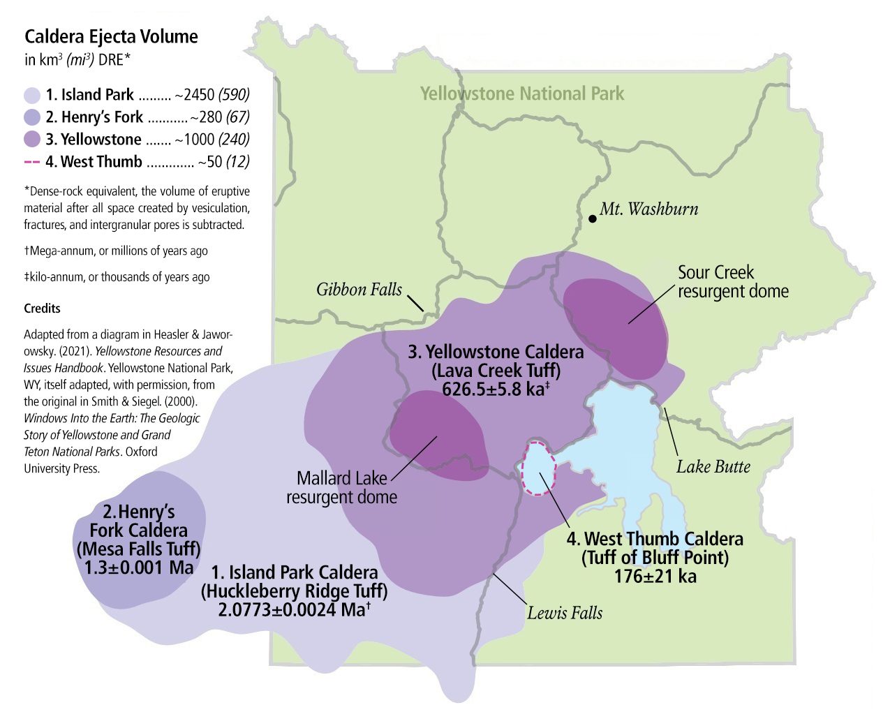
At the present Yellowstone location the hotspot has produced three cataclysmic eruptions. Huckleberry Ridge, about 2.1 million years ago, ejected roughly 2,450 cubic kilometers of material and left a caldera 100 by 80 kilometers. Mesa Falls, about 1.3 million years ago, ejected roughly 280 cubic kilometers and left a caldera 16 by 26 kilometers. Lava Creek, about 640,000 years ago, ejected roughly 1,000 cubic kilometers and left the 85 by 45 kilometer basin that lies within the park today.
| Eruption | When | Ejecta | Caldera |
|---|---|---|---|
| Huckleberry Ridge | About 2.1 million years ago | About 2,450 cubic kilometers | 100 by 80 kilometers |
| Mesa Falls | About 1.3 million years ago | About 280 cubic kilometers | 16 by 26 kilometers |
| Lava Creek | About 640,000 years ago | About 1,000 cubic kilometers | 85 by 45 kilometers |
Two of those three reach the top of the explosivity scale. Our research file's own table puts VEI 8, the mega-colossal class, at more than 1,000 cubic kilometers of ejected material, with a typical recurrence for the class worldwide on the order of once every 100,000 years, and it names Toba (about 74,000 years ago) and Yellowstone (about 640,000 years ago) as its examples. Hold two things about that recurrence figure: it describes a global category, not one volcano's timetable, and Mesa Falls, at roughly 280 cubic kilometers, does not reach the threshold at all.
For scale, and only for scale: Toba's eruption about 74,000 years ago ejected roughly 2,800 cubic kilometers. That is about 1.14 times the ejecta of Huckleberry Ridge, Yellowstone's own largest at roughly 2,450 cubic kilometers, and nearly three times the roughly 1,000 cubic kilometers of Lava Creek, the most recent of the three. Toba has its own file in this wing.
What happened after Lava Creek matters more than the three big events, and it is the part almost nobody hears. In the 640,000 years since that eruption, roughly 30 further eruptions of rhyolitic lava, none of them on the scale of the three, have very nearly filled the basin back in, including a large-volume episode totalling around 600 cubic kilometers between about 180,000 and 70,000 years ago. One caldera did form inside that window, and the map above records it: West Thumb, at about 176,000 years ago and roughly 50 cubic kilometers, well below any of the three. The most recent known lava flow at Yellowstone is the Pitchstone Plateau flow, dated to about 70,000 to 77,000 years ago. Lava flows, not supereruptions, are what this volcano has actually done most often and most recently.
03The Clock That Is Not There
The claim is easy to state, and it is almost always stated the same way: Yellowstone erupts catastrophically on a cycle of roughly 600,000 to 700,000 years, the last such eruption was 640,000 years ago, and the next one is therefore due. It gets repeated constantly, and it is one of the most persistent things anyone says about this park. It also appears in the opening summary of our own research file, which we will come back to.
Our research file carries this as a claim under examination and tags it Tier 2, which in that file's convention means the tier the statement would sit at if you took it at face value, not a finding that it is true. The file then answers it in the same section. Everything below is that answer, and it is not close.
The United States Geological Survey states the position without hedging: Yellowstone is not "overdue" for eruption, and volcanoes do not work that way. The cycle figure comes from averaging the only two gaps that three eruptions can provide. Huckleberry Ridge to Mesa Falls is about 800,000 years. Mesa Falls to Lava Creek is about 660,000 years. Three data points cannot establish a statistical period, and volcanic recurrence is not periodic to begin with. The claim sits on the Yellowstone Volcano Observatory's own named list of the top ten misconceptions about Yellowstone volcanism, presented by Michael Poland, the observatory's scientist-in-charge, in a public lecture and media advisory in November 2021.
The number the USGS does put on it is an annual probability of roughly 1 in 730,000 for a caldera-forming eruption at Yellowstone. Our own research file quotes that figure and says plainly, in the same breath, that it does not mean the volcano is due, because the intervals are irregular. A low-probability, very-high-consequence system is a genuinely different thing from an overdue one, and the difference is not rhetorical.
One correction belongs in this file, and it is ours. The research document behind this article refutes the cycle claim in its counter-arguments section, and then contradicts itself in its own opening summary, where it states that Yellowstone erupts catastrophically roughly every 600,000 to 700,000 years and that the last major eruption was 640,000 years ago. That summary sentence is the exact misconception the rest of the document exists to correct, and it is the sentence a reader is most likely to quote. It is flagged for repair. We would rather print our own contradiction than pass it on.
04What Is Under the Park, and Who Is Watching It
Earlier imaging had already found magma under Yellowstone. Two studies, a year apart, redrew how much of it there is and how deep it goes.
In 2014, Farrell, Smith, Husen and Diehl published a seismic tomography study in Geophysical Research Letters built from 4,520 earthquakes recorded between 1985 and 2013. It imaged Yellowstone's upper-crustal magma reservoir at roughly 90 kilometers long by 30 kilometers wide (about 55 by 19 miles), reaching down to about 16 kilometers (10 miles), with a continuous partial-melt layer at roughly 6 to 12 kilometers depth and an estimated melt fraction of about 9 percent by volume. That is about 2.5 times larger in extent than earlier imaging had shown, and it extends past the caldera's own rim.
In 2015, Huang, Yao, Farrell, Karlstrom and colleagues published a second reservoir in Science, this one in the lower crust at roughly 19 to 45 kilometers (12 to 28 miles) depth, with a volume of about 46,000 cubic kilometers, roughly 4.5 times the volume of the shallower one, and averaging only about 2 percent melt against the upper reservoir's 9 percent. They read it as the conduit connecting the shallow reservoir to the deep mantle plume beneath. Together the two studies gave the first complete image of the Yellowstone magmatic system from plume to upper crust.
Those numbers are easy to read as the discovery of a new danger, and that is not what they are. They are a measurement of something that was already there, and the melt fractions are part of the measurement: about 9 percent molten in the upper reservoir, about 2 percent in the deeper one. A picture is not a warning. The warning, if there is ever to be one, comes from the instruments.
| Instrument | What It Records |
|---|---|
| Yellowstone Seismic Network | Roughly 50 seismometers, jointly operated by the University of Utah Seismograph Stations, USGS ANSS, the Montana Bureau of Mines and Geology, and the EarthScope/NOTA network |
| GPS, strainmeters, tiltmeters | Ground deformation, uplift and subsidence, largely maintained by UNAVCO/EarthScope |
| Gas and water chemistry | Ongoing sampling campaigns across the thermal areas |
| Aerial and satellite survey | Thermal and gas emissions from above |
The watching is done by the Yellowstone Volcano Observatory, a joint operation of the USGS, Yellowstone National Park, and the University of Utah, through four channels: seismic, deformation, chemical, and airborne. It runs continuously, and its output is public.
What that network currently reports is nothing. The USGS states that there is no evidence a catastrophic eruption at Yellowstone is imminent, that such events are unlikely in the next few centuries, and that scientists have found no indication of an imminent smaller eruption of lava either.
It is worth knowing what unrest looks like when it is real. Campi Flegrei, near Naples, has lifted its own ground by more than 3 meters since the 1950s, under a metropolitan area of more than 3 million people. Yellowstone shows no comparable signal in its monitoring record.
05The Heat at the Surface
Everything above is inferred from waves and satellites. The part of the system a visitor can stand next to is the hydrothermal one, and it is the reason the park exists at all.
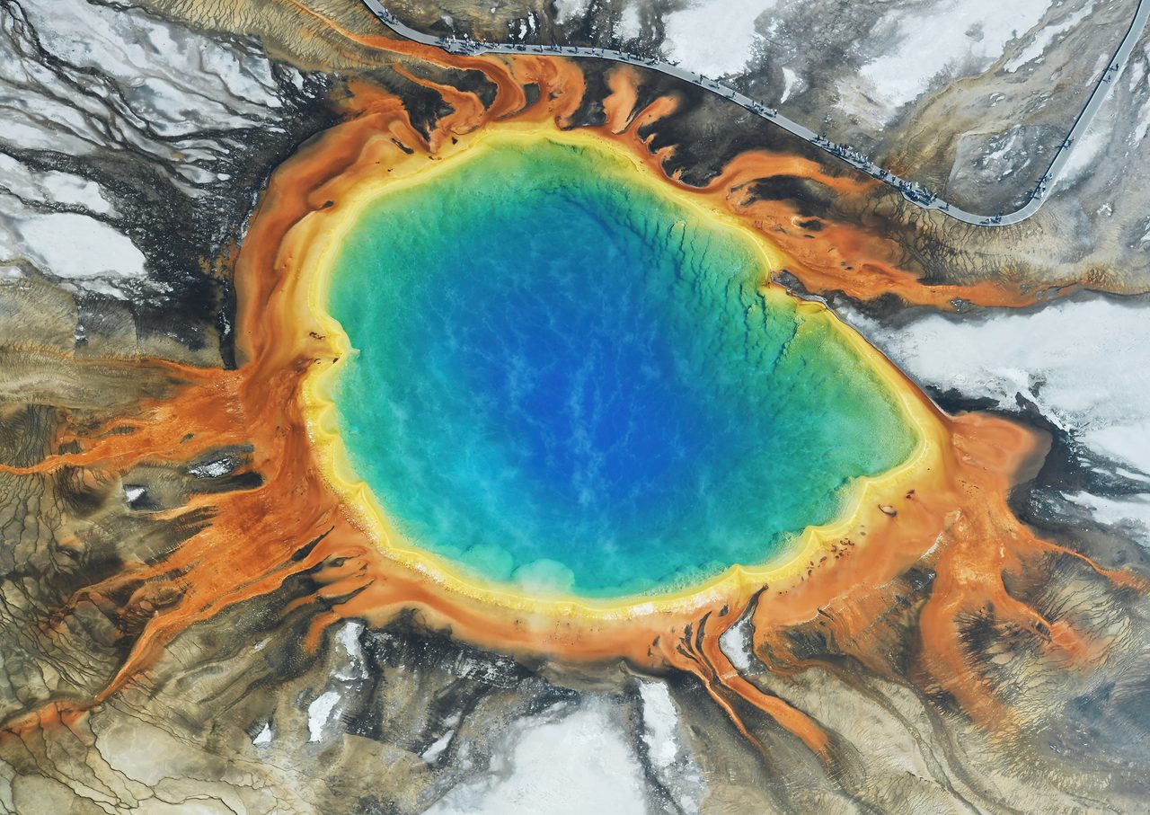
Grand Prismatic Spring, in the Midway Geyser Basin, is the largest hot spring in the United States and the third largest in the world: roughly 200 to 330 feet (60 to 100 meters) across and more than 121 feet (37 meters) deep, with surface water near boiling at roughly 160 degrees Fahrenheit (70 degrees Celsius). The rainbow banding is biology, not mineralogy. Heat-loving bacteria and archaea build microbial mats around the cooler, mineral-rich rim; the deep blue center is too hot and too sterile for them.
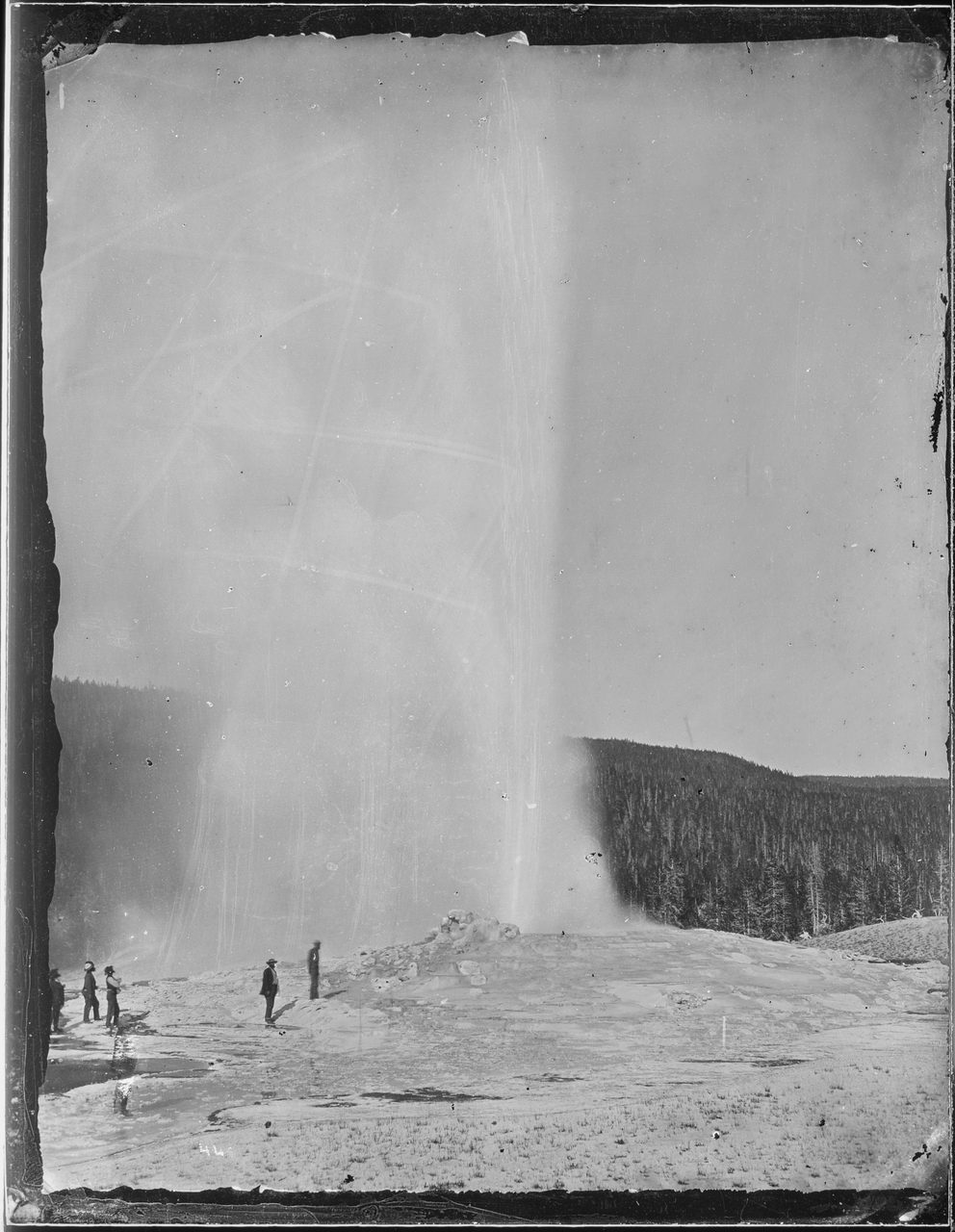
Old Faithful, in the Upper Geyser Basin, erupts on average roughly every 90 minutes and is among the park's most famous geothermal features. Yellowstone was established in 1872 as the world's first national park, in significant part because of features like it. The thermal water earned the protection more than a century before anyone could image the magma beneath it.
That same hydrothermal plumbing is where Yellowstone's most likely hazard comes from. Not the magma. The water.
06What Yellowstone Actually Does
The USGS ranks Yellowstone's possible future activity explicitly, from most to least likely, and the ranking is the single most important fact in this file. Hydrothermal explosions are the most likely: small ones occur every few years, typically forming craters only a few meters across, and every few thousand years a larger one can open a crater up to a few hundred meters across. Lava flows stand beside them in the same most-likely band. An explosive, caldera-forming supereruption is named explicitly as the least likely of Yellowstone's possible eruption types, with a probability in any given century or millennium the USGS describes as exceedingly low.
| Scenario | What the Record and the Ranking Say |
|---|---|
| Hydrothermal explosions | Most likely. Craters a few meters across every few years; a crater up to a few hundred meters across every few thousand years |
| Lava flows | Also among the most likely. Roughly 30 have occurred since the last caldera eruption; the most recent was about 70,000 to 77,000 years ago |
| A caldera-forming supereruption | Explicitly the least likely. Probability in any century or millennium described as exceedingly low; annual probability about 1 in 730,000 |
The hydrothermal record backs the ranking. Since the end of the last ice age in this region, roughly 14,000 years ago, more than a dozen hydrothermal explosions have left craters hundreds of feet across. The largest known hydrothermal explosion crater on Earth is at Mary Bay, on the north shore of Yellowstone Lake, roughly 2.5 kilometers (1.5 miles) wide, formed by an explosion approximately 13,000 to 13,800 years ago.
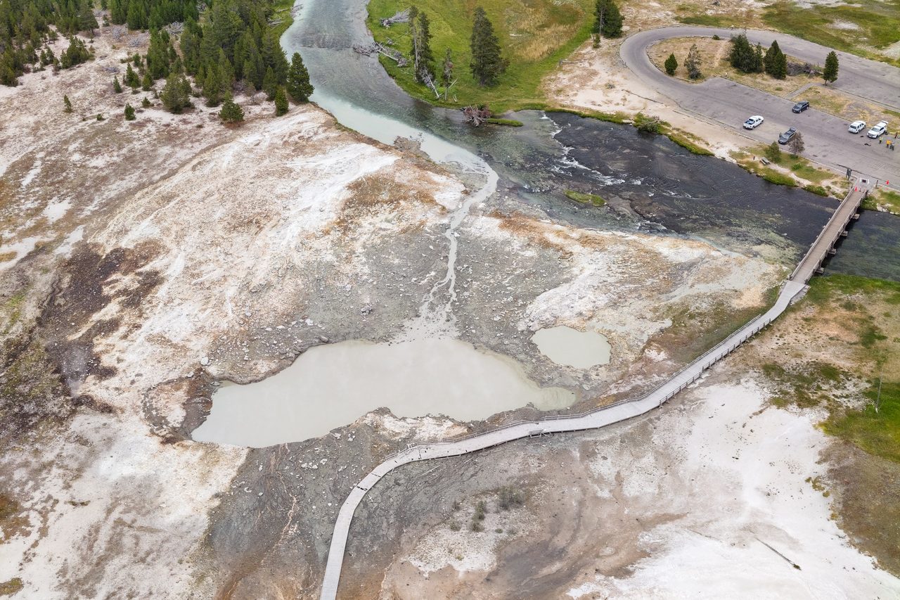
And it happens in the present tense. On July 23, 2024, a hydrothermal explosion at Black Diamond Pool in Biscuit Basin, about 2 miles (3 kilometers) northwest of Old Faithful, threw hot water, mud, and rock roughly 400 to 600 feet (120 to 180 meters) into the air. The boardwalk was heavily damaged and the basin was closed. Nobody was hurt. Because so many visitors were filming, the USGS has called it the best-documented hydrothermal explosion in the park's history.
That is the honest shape of the hazard: not a continent-ending event on a timer, but a real one, with a date and photographs, that closed a boardwalk two miles from Old Faithful. It is less apocalyptic than the myth and considerably more immediate.
07The Least Likely Scenario
The caldera-forming eruption is the one everyone pictures, so it deserves describing precisely, in its proper place: last, as the least likely thing on the list.
If a VEI 8 eruption did occur at Yellowstone, our research file's description of the consequences is severe and specific. Surrounding states would be buried under meters of ash. Pyroclastic flows would extend roughly 100 kilometers from the caldera. Measurable ash would fall across the entire continental United States, and 1 to 3 or more years of volcanic winter would follow, with major agricultural disruption. That is the consequence of the least likely scenario, and it should never be read as a forecast of what Yellowstone is expected to do.
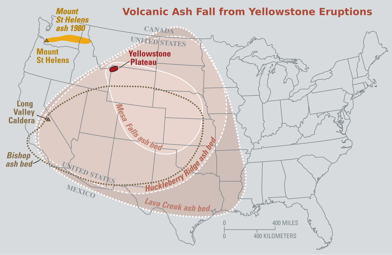
The USGS's own framing of those consequences is narrower than the popular one. It describes a giant eruption as having regional effects such as falling ash, plus short-term changes to global climate on the scale of years to decades. The serious hazards are ashfall distribution and the agricultural disruption that follows. Nothing in that framing supports a biosphere-ending reading, or the claim that such an eruption would kill all life in North America. The difference between those two pictures is the difference between a catastrophe and a fantasy.
Our research file adds one more caution, and it cuts both ways. No human society has ever lived through a VEI 8 eruption in recorded history, so every model of what one would do to a modern civilization remains theoretical. That is a reason to be careful with confident numbers about casualties and collapse, in either direction.
08Where the Claims Run Past the Evidence
A volcano this famous attracts claims that the evidence does not support, and they deserve naming rather than silence.
There is no evidence of any government suppression of Yellowstone monitoring data, and the shape of the refutation is worth noticing: the observatory publishes its monitoring data and its alert-level status continuously and publicly, and issues corrections when false claims circulate. A cover-up is not merely unsupported here. It is refuted by the fact that the data anyone would be hiding is published continuously, in public.
Two dated instances, reported in fact-check coverage in 2024 and 2025, show the pattern in motion. A video circulated claiming to show animals fleeing Yellowstone ahead of an eruption; it was AI-generated, and the real footage showed bison behaving normally on a spring day. A separate viral claim held that the USGS had raised the volcano's alert level to high; the observatory's scientist-in-charge called that one "complete hogwash" in public. Neither claim survived contact with the observatory's own published record.
Fast Facts
- The System
- The Yellowstone hotspot volcano, beneath Yellowstone National Park
- The Track
- Roughly 750 km across the Snake River Plain, beginning about 16.5 to 17 million years ago in northern Nevada and southeastern Oregon
- The Three Eruptions
- Huckleberry Ridge (about 2.1 million years ago), Mesa Falls (about 1.3 million years ago), Lava Creek (about 640,000 years ago)
- The Intervals
- About 800,000 years, then about 660,000 years. Irregular, not a cycle
- Since Then
- Roughly 30 rhyolitic lava flows; the most recent, Pitchstone Plateau, about 70,000 to 77,000 years ago
- The Magma
- An upper reservoir about 90 by 30 km at about 9 percent melt, and a lower-crustal reservoir of about 46,000 cubic km at about 2 percent melt
- The Monitoring
- Yellowstone Volcano Observatory (USGS, the National Park, and the University of Utah): roughly 50 seismometers plus GPS, strainmeters, tiltmeters, and gas monitoring
- Most Likely Future Activity
- Hydrothermal explosions, then lava flows
- Least Likely
- A caldera-forming supereruption; annual probability about 1 in 730,000
- Most Recent Hazard Event
- The hydrothermal explosion at Black Diamond Pool, Biscuit Basin, July 23, 2024
- Current Status
- No evidence of an imminent eruption of any kind
What We Can Actually Stand Behind
The volcano is real, dated, and unusually well measured. A hotspot track roughly 750 kilometers long crosses the Snake River Plain; three caldera-forming eruptions occurred at the present location about 2.1 million, 1.3 million, and 640,000 years ago; two magma reservoirs have been imaged, in the upper and lower crust; and the whole system is monitored continuously by the Yellowstone Volcano Observatory.
No, Yellowstone is not running on a schedule that has expired. The USGS states directly that the volcano is not overdue and that volcanoes do not work that way. Three eruptions give two intervals, about 800,000 years and about 660,000 years, which is not a period, and the annual probability of a caldera-forming eruption is about 1 in 730,000. This is one of the observatory's own named misconceptions, not an open scientific question.
The USGS ranks hydrothermal explosions and lava flows as the most likely future activity and a caldera-forming supereruption as explicitly the least likely. The record agrees: roughly 30 lava flows since the last caldera eruption, more than a dozen hydrothermal explosions in the last 14,000 years, and one at Biscuit Basin on July 23, 2024 that damaged a boardwalk and injured nobody.
No, a Yellowstone supereruption is not an extinction-level event. The USGS's own stated consequences are regional ashfall and short-term global climate change on the scale of years to decades, with agricultural disruption as the serious hazard. The biosphere-ending framing, and the claim that such an eruption would kill all life in North America, are not supported by the evidence and are refused here.
No, an eruption is not imminent, the alert level was not raised to high, animals are not fleeing the park, and nothing is being hidden. There is no evidence a catastrophic eruption is imminent or that a smaller lava eruption is coming. The viral alert-level claim was called "complete hogwash" by the observatory's scientist-in-charge, the fleeing-animals video was AI-generated, and the cover-up claim is refuted by the monitoring data being published continuously and publicly.
The title of this file promises a clock, and the honest finding is that there is not one. What there is instead is a machine we can now describe in unusual detail: a hotspot track 750 kilometers long, two stacked magma reservoirs imaged from the upper crust down toward the plume, roughly 50 seismometers and a net of GPS stations listening to it, and a 640,000-year record of what it has actually done since the last time it emptied itself, which is mostly lava, quietly, and a great deal of hot water. The most interesting thing about Yellowstone is not the eruption it is not having. It is that a system this large can be watched at all, in real time, by anyone who opens the observatory's public data. What nobody can do yet is describe the run-up to a caldera-forming eruption from the inside, because no one has ever watched one begin. If the instruments under the park ever do start writing that sentence, will we recognize the handwriting?
Sources & further reading
Much of what is above is drawn from our own research file on Theories of Anything: the eruption history, the ejecta volumes, the VEI classification, the 1-in-730,000 annual probability, the Toba and Campi Flegrei comparisons, and the description of what a hypothetical supereruption would do. Most of the rest, including the hotspot track, the hazard ranking, the monitoring regime, the hydrothermal-explosion record, and the refusal of the overdue framing, comes from the USGS and Yellowstone Volcano Observatory material named in the text. Section 04 comes from neither. It rests entirely on two published studies, Farrell et al. (2014) in Geophysical Research Letters and Huang et al. (2015) in Science, both linked below, and our own research file contains nothing at all on either one. That gap is logged for repair, alongside the contradiction inside the same file described in section 03. One further note on sourcing, in the open: our file's citation for Clive Oppenheimer's Eruptions That Shook the World (Cambridge University Press, 2011) carries an identifier that resolves to a 2012 review of the book rather than to the book itself, so the work is named here by title and publisher only and the faulty identifier is not reproduced.
Image credits
- Grand Prismatic Spring from the air, Midway Geyser Basin Carsten Steger, via Wikimedia Commons (CC BY-SA 4.0). CC BY-SA 4.0 Source.
- The four major calderas of the Yellowstone volcanic system National Park Service, adapted from Heasler and Jaworowsky (2021), Yellowstone Resources and Issues Handbook, itself adapted with permission from Smith and Siegel (2000), via Wikimedia Commons. Public domain Source.
- Old Faithful in eruption, 1872 Hayden Survey William Henry Jackson, 1872, National Archives, via Wikimedia Commons. Public domain Source.
- Biscuit Basin debris field two days after the July 23, 2024 hydrothermal explosion Jacob W. Frank, National Park Service, via Wikimedia Commons. Public domain Source.
- Ash-fall distribution from the three Yellowstone caldera eruptions U.S. Geological Survey, Fact Sheet 2005-3024, via Wikimedia Commons. Public domain Source.
- Card crop of Grand Prismatic Spring from the air, Midway Geyser Basin Carsten Steger, via Wikimedia Commons (CC BY-SA 4.0). CC BY-SA 4.0 Source.
.jpg)


.jpg)
