
Thera: The Eruption Two Sciences Cannot Agree On
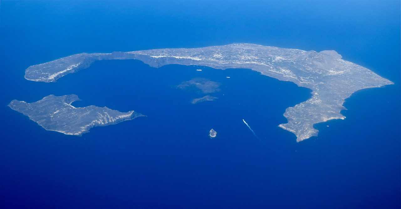
Sometime in the middle of the second millennium BCE, the volcanic island of Thera in the southern Aegean tore itself open. It left a caldera roughly 11 by 7.5 kilometers, sent tsunamis across the eastern Mediterranean, and buried a Bronze Age town under as much as 60 meters of pumice and ash. All of that is well evidenced. When it happened is not. Radiocarbon and tree rings put the eruption near 1600 BCE or earlier; Egyptian pottery synchronisms put it about a century later. Both positions rest on real technical evidence, and the field has not converged. This is the file, opened claim by claim, each one wearing its evidence, with the two chronologies carried side by side and neither one crowned.
Two bodies of specialists look at the same eruption and place it about a century apart. One reads an olive branch that the eruption killed where it stood, frost rings in Irish bog oak and in a bristlecone pine, and a sulfate spike in a Greenland ice core, and lands near 1600 BCE or earlier. The other reads Minoan and Mycenaean pottery sitting in dated Egyptian contexts, and lands near 1500. Neither side is fringe, both rest on evidence rather than assertion, and the gap between them has not closed in decades of argument. Everything else about this eruption, the caldera it left, the waves it sent, the town it buried, is settled far better than the simple question of when. Let's open the file.
01What the Island Did
Thera is the older name for the island now called Santorini, in the southern Aegean. What it did in the Late Bronze Age is written into the island's own layered deposits, and the sequence has been read out of them in detail.
The eruption ran in four main phases, documented by Heiken and McCoy in 1984 and by Druitt and colleagues in 1999. Phase 1 was Plinian: a column rising about 36 kilometers, laying pumice down across Thera and eastern Crete. Phase 2 was phreatomagmatic, water reaching the vent and driving violent explosions and base surges. Phase 3 was the ignimbrite phase, pyroclastic flows sweeping across the island and out into the sea, burying the town of Akrotiri under as much as 60 meters of pumice and ash. Phase 4 was collapse: the emptied magma chamber gave way beneath the island.
That fourth phase is the part still visible from the air. The centre of the island dropped into a caldera roughly 11 by 7.5 kilometers, now flooded by the sea. The island did not simply erupt and settle. It lost its middle.
02The Number That Keeps Moving
Ask how big the eruption was and the answer depends on which decade and which method you ask. That is worth walking through slowly, because the tidy version of this story, estimates revised steadily upward as instruments improved, is not what the literature actually did.
Our own research file puts total ejecta at 30 to 80 cubic kilometers of bulk tephra, with a dense rock equivalent figure of about 40 cubic kilometers in its summary. Dense rock equivalent, or DRE, is the same material with the gas and pore space taken back out and stated as solid rock, so it is always the smaller of the two numbers. On its own figures the file puts the eruption at 2 to 5 times the size of Krakatoa in 1883 (about 25 cubic kilometers), and names Tambora in 1815 (about 160 cubic kilometers) as this eruption's only Holocene rival.
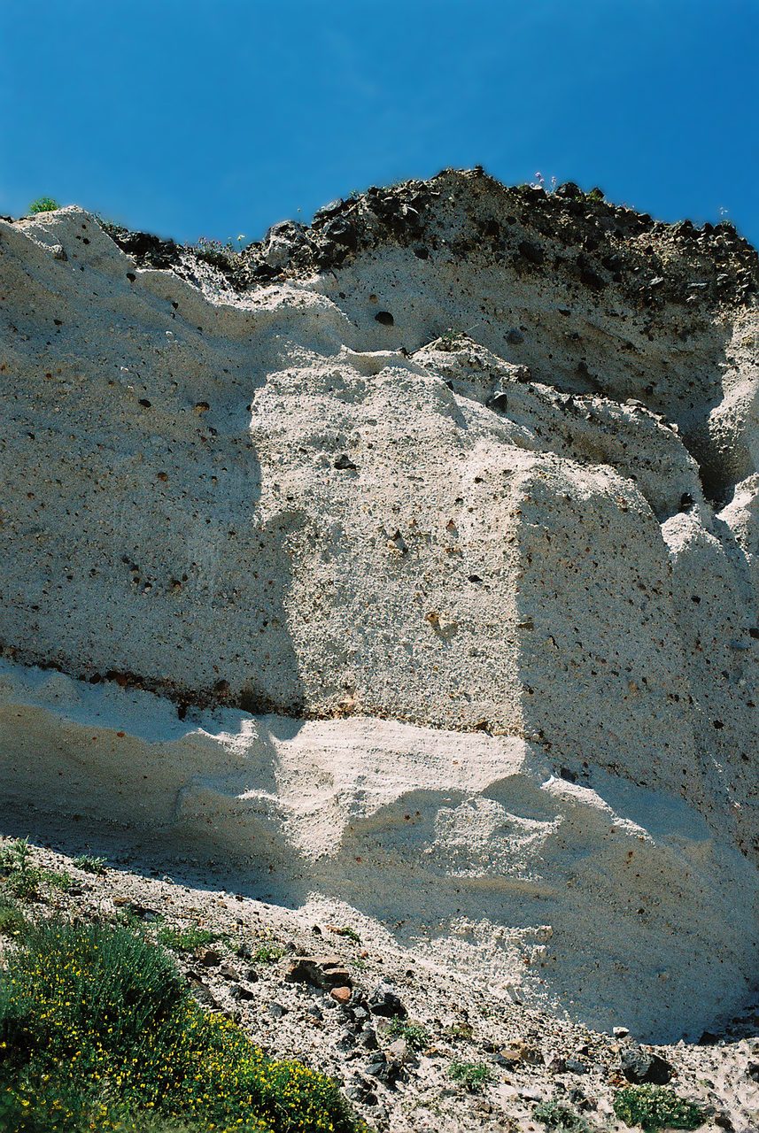
The most recent and most rigorous reconstruction gives a smaller number than that. Karstens, Preine and colleagues, publishing in Nature Communications in 2023, combined seismic reflection surveying, P-wave tomography and CT-derived sedimentological data into a single joint reconstruction, and arrived at a total volume of 34.5 cubic kilometers DRE, give or take 6.8. That total breaks down as 21.4 cubic kilometers of tephra fall (give or take 3.6), 6.9 of ignimbrites (give or take 2), and 6.1 of intra-caldera deposits (give or take 1.2). The pyroclastic flow volume, on this reconstruction, is significantly smaller than had previously been assumed.
The honest shape of that history is not a line going up. Pyle's 1990 estimate was about 28 to 30 cubic kilometers DRE. The literature across the 1990s and 2010s then carried a range of progressively higher figures, reaching as high as 60 to 86 cubic kilometers DRE, and our own library still sits inside that older spread: one sister file on this eruption gives 60 cubic kilometers DRE and another gives 40 to 60. The 2023 joint reconstruction revises the figure back down, landing close to where Pyle started. This is a story of estimates converging on precision, not of a catastrophe growing in the retelling, and the eruption is very large either way.
The explosivity class did not move with the volume. Sources still classify the eruption as VEI 6 to 7, most often citing VEI 7 flatly, and that has held through the whole revision history. There is a plausible reason for the hedge, and it is arithmetic rather than argument: the Volcanic Explosivity Index is conventionally keyed to bulk tephra volume, with VEI 7 requiring more than 100 cubic kilometers bulk and VEI 6 spanning 10 to 100, so a 34.5 cubic kilometer DRE figure converts to a bulk estimate sitting nearer that boundary than the older, larger DRE figures did. We offer that as an explanation of why the sources hedge, our own reading connecting two published facts, not as a finding any single paper states.
| Estimate | Figure | Note |
|---|---|---|
| Pyle, 1990 | About 28 to 30 cubic km DRE | The original baseline |
| The literature, 1990s to 2010s | A range of higher figures, reaching as high as 60 to 86 cubic km DRE | The period the corpus figures below were drawn from |
| Our file E_1_16 | 30 to 80 cubic km bulk tephra; about 40 cubic km DRE in summary | The primary file behind this article |
| Our file E_2_03 | 60 cubic km DRE | A sister file on the same eruption |
| Our file E_2_18 | 40 to 60 cubic km DRE | A second sister file; our three files do not agree with each other |
| Karstens et al., 2023, Nature Communications | 34.5 cubic km DRE, give or take 6.8 | Seismic reflection, P-wave tomography and CT sedimentology combined; the current best reconstruction, and a revision downward |
03The Town Under the Pumice
The pyroclastic phase sealed a settlement on the island's southern side, and the seal is why we have it. Akrotiri is not a ruin weathered down over three and a half millennia. It is a Bronze Age town with its walls still standing to their upper floors.
Akrotiri was excavated by Spyridon Marinatos from 1967 to 1974, a campaign that ended when Marinatos was killed in an accident on the site. Christos Doumas took over the excavation in 1975 and has directed it since.
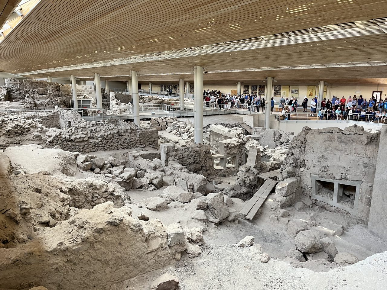
What the deposits preserved is a prosperous Minoan town, more than 20,000 square meters of it uncovered and likely a good deal larger. Buildings stand up to three storeys. There is indoor plumbing, there are flushing toilets, and there is a sophisticated drainage system. In urban quality it is comparable to Knossos.
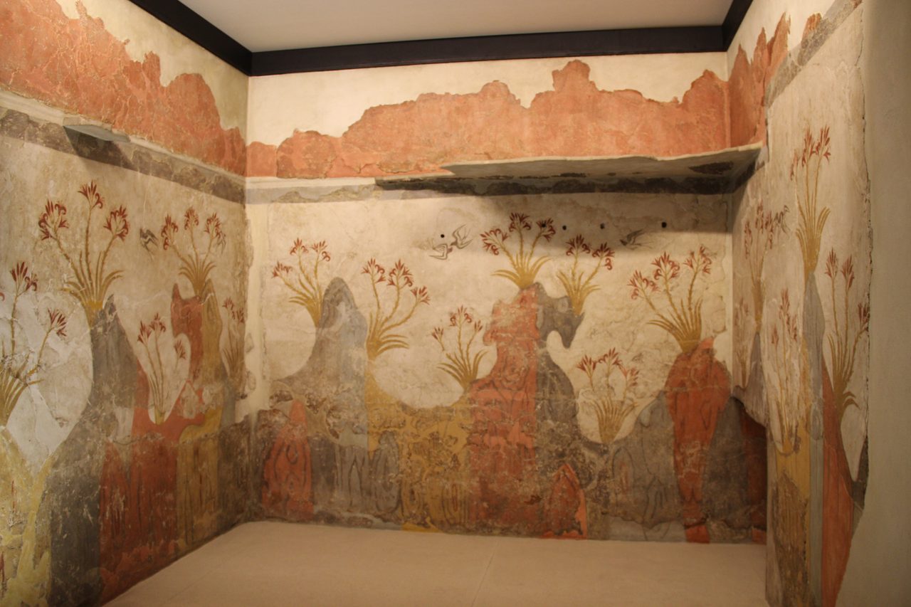
The wall paintings survive, and they are exceptional. Among them are the Spring Fresco, with its swallows and lilies; the Boxing Boys; the Saffron Gatherers; the Fisherman; and the Flotilla Fresco, a detailed naval procession with ships, dolphins and coastal towns in it. This is not a fragmentary record of Bronze Age Aegean life. It is a painted one.
The comparison everyone reaches for is Pompeii, and our library makes the point sharper than the nickname does: Akrotiri was buried roughly 1,600 years before Pompeii was, in 79 CE, and its preservation is comparable to Pompeii's and in some respects better. The Pompeii of the Bronze Age is an epithet that survives scrutiny.
One number should sit under everything said about Akrotiri. Only about 3 percent of the site has been excavated. The rest is still under the volcanic deposits, and every statement in this article about what Akrotiri contains is a statement about that fraction.
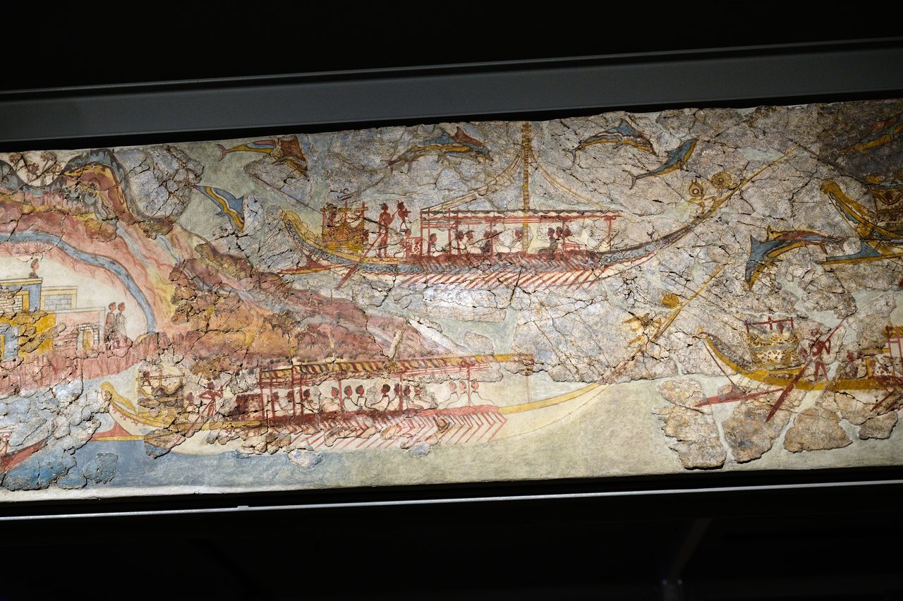
The major finds from the site are held by the National Archaeological Museum in Athens.
04The Empty Rooms, and the Body on the Turkish Coast
The most quoted fact about Akrotiri is that nobody is in it. That fact is real, and it is routinely stated in a form the evidence does not support. Both halves belong together.
No human remains have been found at Akrotiri, and few portable valuables. The reading is that the population left before the main eruption, possibly warned by earthquakes running ahead of it.
The site itself carries the warning in its fabric. There is earthquake damage that had been partly repaired before the final eruption, and construction debris that was in the process of being cleared. Read together, that points to a run-up of weeks to months of tremors, which puts specific ground under the primary file's careful 'possibly warned by precursory earthquakes'.
People did die in this event, and in 2022 one of them was found. Sahoglu and colleagues, publishing in the Proceedings of the National Academy of Sciences, reported excavations at Cesme-Baglararasi on Turkey's Aegean coast that recovered an articulated human skeleton, a young man, together with the skeleton of a dog, inside tsunami debris tied stratigraphically to the Thera eruption. Coverage described him as the first known human victim directly associated with the Late Bronze Age Thera tsunami. The positioning of the body suggests survivors dug temporary graves that later waves then filled in.
So the precise version is this. In the roughly 3 percent of Akrotiri that has been dug, there are no human remains and few portable valuables, and that is best read narrowly: that one town got an organized, warned evacuation out ahead of the final phases. It is not evidence that the catastrophe killed nobody in the Aegean. The Turkish coast has produced a body in the tsunami debris of this same event. Akrotiri emptied. The wider disaster did not spare everyone.
05The Waves
A caldera collapse of this size displaces an enormous volume of water, and the Aegean is not a large sea to absorb it. The tsunami evidence comes in two forms: modeled wave heights, and physical deposits found where the waves ran ashore.
Modeling by Pareschi and colleagues in 2006 and by Novikova and colleagues in 2011 gives wave heights of 9 to 15 meters on the northern coast of Crete.
Our file E_2_18 states the modeling results differently, and the difference is worth naming rather than smoothing over. Drawing on Novikova and colleagues in 2011 together with Nomikou and colleagues in 2016, it gives maximum wave heights of about 35 meters and above on Thera's own coast, roughly 5 to 15 meters on the northern coast of Crete, and measurable waves throughout the eastern Mediterranean. The Thera figure is a different coastline at a different distance from the source and does not conflict with anything. The Crete figure, 5 to 15 against 9 to 15, is our files E_1_16 and E_2_18 reporting the same modeling literature with different lower bounds, and this article does not adjudicate between them.
The deposits are the harder evidence. Layers of marine sediment, pumice and pottery debris identified as tsunami deposits have been found at multiple coastal sites on Crete, including Palaikastro, Pseira, and possibly Amnissos, the port of Knossos.
The reach is wider than Crete. Eastern Mediterranean tsunami deposits attributed to this eruption have also been reported on the Israeli coast and the western Turkish coast, including a destruction layer of marine debris lying over Late Bronze Age occupation at Cesme-Baglararasi, the same site that later produced the skeleton.
What that would have meant for a seafaring economy is not hard to state. Waves on that scale would have devastated the Minoan maritime economy, destroying harbors, warehouses and fishing fleets. What follows from that damage over the next generations is a separate and much more contested question, and it is handled at the end of this file rather than assumed here.
| Place | What Was Found Or Modeled |
|---|---|
| Thera's own coast | Modeled maximum wave heights of about 35 meters and above (Novikova et al. 2011, Nomikou et al. 2016) |
| Northern coast of Crete | Modeled at 9 to 15 meters (Pareschi et al. 2006, Novikova et al. 2011); our file E_2_18 gives roughly 5 to 15 meters from the same modeling literature |
| Palaikastro, Pseira and possibly Amnissos, Crete | Physical tsunami deposits: layers of marine sediment, pumice and pottery debris |
| The Israeli coast and the western Turkish coast | Eastern Mediterranean tsunami deposits attributed to the eruption |
| Cesme-Baglararasi, western Turkey | A destruction layer of marine debris over Late Bronze Age occupation; a 2022 PNAS excavation recovered a human skeleton and a dog skeleton in the tsunami debris |
| The wider eastern Mediterranean | Measurable waves throughout, on the same models |
06The Sky, and Two Ancient Texts
An eruption this size puts sulfur into the stratosphere, and sulfur in the stratosphere cools the surface. How much of either happened here is one of the softer parts of the file, and the numbers should be handled as the ranges they are.
Modeling puts stratospheric sulfur dioxide release somewhere in the range of 10 to 200 teragrams. If the true figure is at the higher end of that range, hemispheric cooling of 1 to 3 degrees C for 1 to 3 years is plausible. That is a very wide range, our own file flags the magnitude as debated, and the primary file for this eruption carries no sulfur or cooling figure at all. This is an estimate with a factor of twenty in it, not a measurement.
One Egyptian text is repeatedly brought into this. The Tempest Stela of Ahmose I, dated to about 1550 BCE or earlier with its own date disputed, describes a great storm bringing darkness and destruction across Egypt. Karen Polinger Foster and Robert Ritner argued in 1996 that this may be an account of the eruption's atmospheric effects. The interpretation is contested: others read the stela as describing a local storm, or as metaphorical and propagandistic rather than meteorological.
A second text sits further out. The Bamboo Annals record unusual cold, frost and famine in China during the reign of King Chieh of the Xia dynasty, and this has been tentatively correlated with Thera's climatic effects. The correlation depends entirely on which dating scheme is used for the eruption, which makes it a poor witness in an argument about the dating and a fragile one on its own terms. Our own file's language is 'tentatively correlated', and this article will not upgrade it.
07The Century Two Sciences Cannot Close
Here is the argument the title points at. It is not a fight between science and folklore, or between rigor and sentiment. It is two disciplines applying their own best methods to the same event and getting answers about a century apart, and both methods have a track record.
The high chronology's anchor is a single piece of wood. Friedrich, Kromer, Friedrich, Heinemeier, Pfeiffer and Talamo, publishing in Science in 2006, radiocarbon dated an olive branch found in place on Thera and killed by the eruption itself, and got 1627 to 1600 BCE at 95.4 percent confidence, recalibrated against the IntCal curves. A branch buried alive by the event dates the event, with no chain of intermediate assumptions between the sample and the eruption.
That date does not stand alone. It is consistent with frost rings in Irish bog oak at 1628 BCE, reported by Baillie and Munro in 1988; with a bristlecone pine frost ring at 1627 BCE; and with a sulfate spike in the GISP2 Greenland ice core at about 1642 BCE, although attributing that spike to Thera specifically is debated, since other eruptions may have contributed to it. Note that the ice-core figure is close to the tree-ring years rather than identical with them, and that the tree rings record a cold event, not an eruption's name.
The low chronology has its own anchor, and it is not a hunch. Manfred Bietak of the Austrian Archaeological Institute, excavator of Tell el-Dab'a, ancient Avaris, and Peter Warren of the University of Bristol argue for about 1530 to 1500 BCE on the basis of Egyptian pottery synchronisms: Minoan and Mycenaean pottery recovered from Egyptian contexts that are themselves dated, tying the Aegean ceramic sequence to the Egyptian historical calendar. That is a positive argument built on stratified, dated material, not merely an objection to somebody else's.
The low chronology also carries a specific technical objection to the radiocarbon dates. Malcolm Wiener argued in 2009 that samples from a volcanic setting may be skewed by a carbon dioxide reservoir effect, old carbon vented by the volcano itself contaminating the material being dated and pushing the apparent age older than the true one. Friedrich and Heinemeier contest the objection. It is not a wave of the hand at radiocarbon in general; it is a named mechanism that would bias results in exactly the direction the disagreement runs.
The reason neither side can quietly concede is that the bill comes due elsewhere. Our own file's counter-argument section states it plainly: if the high chronology is correct, Egyptian chronology for the Second Intermediate Period requires revision, with cascading effects through the entire eastern Mediterranean Bronze Age timeline; if the low chronology is correct, multiple radiocarbon dates, dendrochronological markers and ice-core signals have to be reinterpreted. Sturt Manning of Cornell has assembled the most comprehensive defense of the high chronology, in A Test of Time (1999, revised 2014). This is a discrepancy of more than 100 years, and it is the central unresolved problem in the file.
| Position | Who | The Date | What It Rests On | What It Costs If It Is Right |
|---|---|---|---|---|
| High chronology (radiocarbon, tree rings, ice cores) | Friedrich et al. (2006); Sturt Manning, Cornell | 1627 to 1600 BCE at 95.4 percent on the olive branch; 1606 to 1589 BCE at 68.3 percent, or 1609 to 1560 at 95.4 percent, on a 2022 Bayesian re-analysis | An olive branch killed in place by the eruption and radiocarbon dated; Irish bog oak frost rings at 1628 BCE; a bristlecone pine frost ring at 1627 BCE; a GISP2 sulfate spike at about 1642 BCE, attribution debated; a Bayesian integration of Aegean radiocarbon datasets on and away from Thera, plus tree-ring wiggle-matching at Miletos | Egyptian chronology for the Second Intermediate Period must be revised, with cascading effects through the whole eastern Mediterranean Bronze Age timeline |
| Low or archaeological chronology (synchronisms) | Manfred Bietak, Austrian Archaeological Institute, excavator of Tell el-Dab'a and Avaris; Peter Warren, University of Bristol; synchronism proponents citing Hoflmayer 2012 and Bietak 2013; plus Bietak (ed.), 'Radiocarbon and the Date of the Thera Eruption', Antiquity 88(339): 277-282 (2014), listed in our primary file's bibliography and unread by us | About 1530 to 1500 BCE; current synchronism work still places the eruption near 1500 BCE | Egyptian pottery synchronisms: Minoan and Mycenaean pottery recovered from dated Egyptian contexts, tying the Aegean sequence to the Egyptian historical calendar; plus the argument that radiocarbon samples here carry old volcanic carbon (Wiener 2009) | Multiple radiocarbon dates, dendrochronological markers and ice-core signals must all be reinterpreted |
| The reconciling result | Pearson et al. (2018), Science Advances | About 1600 to 1525 BCE | An annual-resolution radiocarbon calibration series for 1700 to 1500 BCE built from calendar-dated individual tree rings, bristlecone pine and Irish oak, which found the existing calibration curve carried inaccuracies in that specific window | It overlaps the archaeological estimate of about 1570 to 1500 BCE, a slightly wider window than the 1530 to 1500 in the row above, as each source states it. And it did not end the argument. See the next section |
08Three Findings, Three Directions
The last decade has produced work that moves this question, and three results matter here. They do not line up behind one answer. One caution belongs in front of them, in the same spirit as the correction that closes this section: all three are radiocarbon-side publications, and so is every study from that decade this article names on the dating question. That is a fact about this article's sourcing rather than a score in the argument. The archaeological case has gone on being argued through the same years, in a body of synchronism scholarship our own files do not engage and this research pass reached only as titles and abstracts. The nearest thing to it we can put in front of you sits just outside that decade, in a work our primary file's own bibliography lists and we have not read: Manfred Bietak's edited 'Radiocarbon and the Date of the Thera Eruption', Antiquity 88(339), pages 277 to 282, 2014, carried here by name and unverified beyond plausibility, on the same footing as Hoflmayer 2012 and Bietak 2013. An imbalance in what we can show is not evidence about which side is right.
In 2018 Pearson and colleagues published in Science Advances a result that moved radiocarbon toward the archaeologists. Building an annual-resolution radiocarbon calibration series for 1700 to 1500 BCE out of calendar-dated individual tree rings from bristlecone pine and Irish oak, the team found that the existing calibration curve carried inaccuracies in exactly that window. Their revised calibration shifts the compatible eruption date to roughly 1600 to 1525 BCE, overlapping the archaeological estimate of about 1570 to 1500. That is a slightly wider window than the about 1530 to 1500 our own primary file gives for the same position, and the two are carried here as their sources state them rather than reconciled. The lead author's own stated conclusion, as the study's own institutional announcement quoted him, was that 'the radiocarbon evidence is compatible with the archaeological evidence for an eruption of Thera in the 16th century BC.' A radiocarbon study, narrowing toward the low chronology.
In 2022 Manning published in PLoS ONE a large Bayesian re-analysis that pushed the other way. It integrated radiocarbon datasets from Aegean contexts both on Thera and far from it, tree-ring wiggle-match dating at Miletos, and olive-wood samples killed by the eruption, and refined the date to 1606 to 1589 BCE at 68.3 percent probability, or 1609 to 1560 BCE at 95.4 percent. That supports the high chronology and puts the eruption in Egypt's Second Intermediate Period, a Canaanite and Levantine dominated era, rather than the New Kingdom that the archaeological chronology assumes. The same study tested the reservoir-effect objection directly, comparing radiocarbon dates from distant and presumed uncontaminated sites against Thera-proximal samples, and found no substantive difference between them.
Neither result closed the case. The dispute remains genuinely unresolved in the 2024 and 2025 literature. Manning published again in 2024, in 'Thera, the Aegean, Egypt, the Hyksos and Anatolia: Rethinking the orthodox synchronisations and histories', still arguing the high chronology, while archaeological synchronism proponents continue to place the eruption near 1500 BCE. The framing our research pass found in the current literature is that several decades of debate have followed with no clear resolution, despite wide recognition that the uncertainty undermines any ability to synchronize the civilizations of the eastern Mediterranean in the middle of the second millennium BCE.
One correction to our own file belongs here, because this article is built on it. E_1_16 states that as of 2025 the high chronology is favored by most scientists, while the low chronology retains support among some Aegean and Egyptian archaeologists. That is not false, and it is not the whole picture: the file does not engage the 2018 reconciling recalibration, the 2022 Bayesian defense, or the debate's continuation into 2024, all of which complicate a simple reading of who is winning. This article carries the fuller version, and names no winner.
09Atlantis, Briefly
Any file on Thera has to say something about Atlantis, because every reader arrives already holding the question. Here is the whole of what this article has to say about it, at the tier the evidence earns. The Atlantis identification itself belongs to a different file.
The idea that Plato's Atlantis, in the Timaeus and the Critias of about 360 BCE, was inspired by the destruction of Minoan Thera was proposed by K. T. Frost in 1909 and elaborated by Spyridon Marinatos in 1939 and A. G. Galanopoulos in the 1960s. The points of comparison are real enough: an advanced island civilization with concentric harbors, destroyed by cataclysm, sinking beneath the sea. So are the points against. Plato put Atlantis in the Atlantic Ocean beyond the Pillars of Heracles, and dated it to about 9600 BCE. Neither matches Thera. The connection is evocative and it remains unproven.
The same applies, further out, to the biblical plagues of Exodus. Some writers have linked the eruption's darkness, tsunami and crop failure to that narrative. This stays highly speculative: the chronological fit is uncertain, the distance from Thera to the Nile Delta is roughly 900 kilometers, and there is no accepted archaeological evidence for the Exodus as a historical event to fit anything to.
10Where the Claims Run Past the Evidence
One claim about this eruption is repeated more than any other, and it is the one the evidence refuses. It is worth stating flatly, because it is also the claim this article's own working title once made.
No, the eruption did not destroy Minoan civilization instantly. The archaeological evidence shows clearly that the Minoan palaces on Crete survived the eruption by generations. The civilization's collapse around 1450 BCE had multiple causes, Mycenaean military action among them. The instant-destruction version is a misconception, and our own file's Tier 4 section names it as one.
What the record shows instead is continuity. The palaces at Knossos, Phaistos, Malia and Zakros were not abandoned after the eruption; there is evidence of continued occupation and rebuilding, the phase archaeologists call Final Palatial. The collapse came about 50 to 150 years later, around 1450 BCE, when the palaces were destroyed by fire and Mycenaean Greeks took control of Knossos.
That leaves a real question about the eruption's role, and our file's own answer is a careful one: the role is indirect rather than immediate. Destruction of the fleet, disruption of trade networks, loss of the Theran colony, agricultural damage from tephra fall on eastern Crete, and a possible psychological or religious crisis may between them have weakened the Minoan state enough for a Mycenaean takeover to become possible. May have. Every link in that chain is an argument, not a measurement.
The framework our library describes as the most widely accepted current view is explicitly multi-causal. Knappett and Nikolakopoulou proposed in 2015 that eruption, earthquake damage, trade disruption, internal social stress and Mycenaean pressure combined, which is a more moderate position than Marinatos's original 1939 thesis of direct volcanic destruction. Separately, Jan Driessen and Colin Macdonald have argued that the eruption triggered a political crisis on Crete, possibly a revolt against palace elites who had failed to protect the population.
None of that is settled, and this file does not try to settle it. What happened to Minoan Crete over the following century and a half is a larger question than one eruption, with more evidence in it than this article carries, and the honest position is that the eruption is one input to a contested multi-causal problem rather than its answer.
Fast Facts
- The Event
- The Late Bronze Age eruption of Thera, now Santorini, southern Aegean Sea; geologists call it the Minoan eruption
- When
- Disputed by about a century: 1627 to 1600 BCE on radiocarbon and tree rings, about 1530 to 1500 BCE on Egyptian pottery synchronisms
- The Caldera
- Roughly 11 by 7.5 km, formed when the emptied magma chamber collapsed
- Eruption Column
- About 36 km high in the opening Plinian phase
- The Phases
- Plinian column, then phreatomagmatic surges, then pyroclastic flows and ignimbrite, then caldera collapse
- Volume
- 30 to 80 cubic km bulk tephra in our own file; the most recent joint reconstruction gives 34.5 cubic km DRE, give or take 6.8 (Karstens et al. 2023)
- Explosivity
- Cited as VEI 6 to 7, most often VEI 7; unchanged through every revision of the volume
- Tsunamis
- Modeled at about 9 to 15 m on northern Crete; deposits found on Crete, the Israeli coast and the Turkish coast
- Akrotiri
- A Minoan town buried under as much as 60 m of pumice and ash; more than 20,000 square meters uncovered in our primary file, and separately our sister files put the excavated share at only about 3 percent, neither figure derived from the other
- Human Remains
- None in the excavated part of Akrotiri; one victim recovered from tsunami debris at Cesme-Baglararasi, Turkey, reported in 2022
- The Minoan Collapse
- About 50 to 150 years after the eruption, around 1450 BCE; the eruption's role is debated, indirect rather than immediate
- Atlantis
- Proposed by Frost (1909), Marinatos (1939) and Galanopoulos (1960s); unproven, and Plato's own location and date do not fit
What We Can Actually Stand Behind
The eruption is real, mapped and severe. It ran in four phases from a Plinian column about 36 kilometers high to a caldera collapse that dropped the island's centre into a basin roughly 11 by 7.5 kilometers. It buried the town of Akrotiri under as much as 60 meters of pumice and ash and preserved it, walls, plumbing and painted rooms together. It generated tsunamis modeled at 9 to 15 meters on northern Crete and left physical deposits at Palaikastro, Pseira and possibly Amnissos, on the Israeli coast, and on the western Turkish coast. The excavated part of Akrotiri holds no human remains and few valuables, consistent with an organized evacuation; a 2022 PNAS excavation at Cesme-Baglararasi in Turkey recovered a human skeleton in this event's tsunami debris. Both of those facts are true at once.
The dating dispute is real, and it is a disagreement between two well-evidenced positions rather than between evidence and its absence. An olive branch killed in place by the eruption dates to 1627 to 1600 BCE at 95.4 percent confidence, corroborated by frost rings at 1628 and 1627 BCE and, more loosely, by a Greenland sulfate spike at about 1642 BCE whose attribution is debated. Egyptian pottery synchronisms from dated contexts put the eruption at about 1530 to 1500 BCE, and that is positive stratified evidence, not merely an objection. A 2018 tree-ring recalibration moved the radiocarbon range toward the archaeologists; a 2022 Bayesian re-analysis moved it back and found no reservoir-effect bias when it looked for one; a 2024 paper continued the argument. This article names no winner, because the field has not.
The softer layer is genuinely soft. Stratospheric sulfur dioxide release is modeled at somewhere between 10 and 200 teragrams, with hemispheric cooling of roughly 1 to 3 degrees C for roughly 1 to 3 years plausible only at the top of that range. The Tempest Stela of Ahmose I may record the eruption's atmospheric effects, or a local storm, or nothing meteorological at all. Only about 3 percent of Akrotiri has been dug. Our files E_1_16 and E_2_18 report modeled Crete wave heights with different lower bounds. And the eruption's relationship to the Minoan collapse of around 1450 BCE, roughly 50 to 150 years later, is indirect, contested and multi-causal on every reading our library carries.
Atlantis, Exodus and the Bamboo Annals all sit here. The Atlantis identification has a real intellectual lineage from Frost to Marinatos to Galanopoulos and real points of comparison, and it also has Plato's own Atlantic location and his date of about 9600 BCE working against it. The Exodus link stays highly speculative, with an uncertain chronological fit, roughly 900 kilometers of distance, and no accepted archaeological evidence for the Exodus as an event. The Bamboo Annals record of cold and famine in China is tentatively correlated at best, and which correlation you get depends on which chronology you already believe.
No, this eruption did not destroy Minoan civilization instantly. The palaces on Crete survived it by generations, with continued occupation and rebuilding through the Final Palatial phase, and the collapse around 1450 BCE had multiple causes including Mycenaean military action. Any telling of this event that ends with a civilization wiped out in an afternoon is telling something the excavated record contradicts.
So the file closes where it opened. We can give the column height, map the caldera, count the layers in the cliff, model the waves, and name the frescoes on the walls of a town whose people had already gone. What we cannot do is say which century it happened in. Two bodies of evidence, each internally coherent and each defended by careful people, land about a century apart, and the most recent studies point in different directions from one another. The cost of that is not confined to one island: this eruption is the peg that would let the Aegean, Egypt and the Levant be lined up against each other in the middle of the second millennium BCE, and while the peg floats, they cannot be. Which leaves the question the evidence itself keeps asking. If two methods this good can differ by a century about an event this large and this well preserved, what are we actually holding when we say we have dated the Bronze Age?
Sources & further reading
Everything above is drawn from our research library on Theories of Anything, together with five external papers named in the prose: Pearson et al. (2018), Manning (2022 and 2024), Karstens et al. (2023), and Sahoglu et al. (2022). Those five were checked to different depths, and the difference is worth stating. Manning (2022) and Karstens et al. (2023) were read in their full published texts. The Pearson (2018) paper itself returned an access block on direct fetch, so its result and the conclusion quoted above come from the study's own institutional announcement and from independent science-press coverage rather than from the paper's own pages. The Sahoglu et al. (2022) PNAS report was likewise taken from corroborating coverage rather than the paper itself. Manning's 2024 follow-up is cited by title as a currency signal, with its full venue details unconfirmed. Several works cited in the underlying file are named here without links, and the reason is worth stating in the open. Three of its bibliography entries carry DOIs that do not resolve to the works they are attached to: the DOI on Druitt and colleagues' Santorini Volcano (Geological Society Memoir 19, 1999) resolves to a 2001 review of that memoir in another journal; the DOI on Manning's A Test of Time resolves to a 2003 review of the book rather than the book; and the DOI on Doumas's The Wall-Paintings of Thera (1992) resolves to a different work entirely, a 2008 Antiquity article with five authors. The works themselves are real and correctly described in the file, so they are cited by name above and left unlinked here rather than pointed at the wrong destination. Baillie and Munro (1988), Bietak (ed., 2014), Pareschi et al. (2006), Nomikou et al. (2016), Heiken and McCoy (1984), Foster and Ritner (1996), Wiener (2009), Knappett and Nikolakopoulou (2015), Driessen and Macdonald (1997) and Sahoglu et al. (2022) carry no stable identifier in our own files and are likewise cited by name. Open the full file to check the sourcing and go deeper.
Image credits
- The Santorini caldera from the air Steve Jurvetson, via Wikimedia Commons. CC BY 2.0 Source.
- Pumice deposit exposed in a cliff near Akrotiri Ulrichstill, via Wikimedia Commons. CC BY-SA 4.0 Source.
- The excavated town at Akrotiri under its modern shelter Annita Banou, via Wikimedia Commons. CC BY 4.0 Source.
- The Ship Procession fresco, West House, Akrotiri Zde, via Wikimedia Commons. CC BY-SA 4.0 Source.
- The Spring Fresco, Room D2, Complex D, Akrotiri Gary Todd, via Wikimedia Commons. CC0 1.0 Source.
- Card crop of The Santorini caldera from the air Steve Jurvetson, via Wikimedia Commons. CC BY 2.0 Source.


.jpg)