
The Messinian Salinity Crisis: A Kilometre of Salt, and an Argument About How Dry It Got
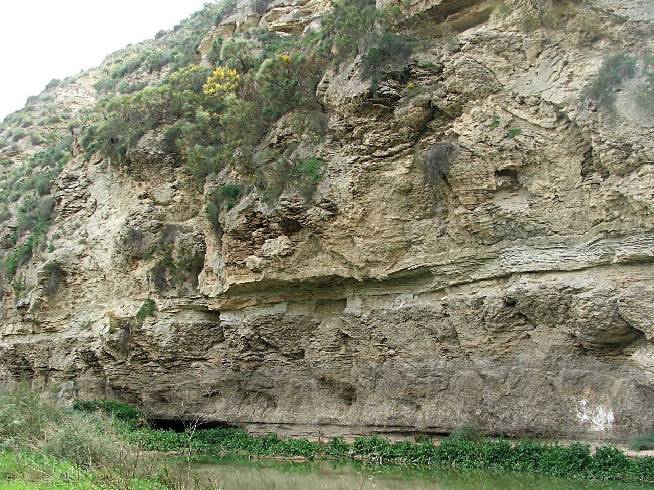
Beneath the floor of the Mediterranean lies a body of salt, gypsum and anhydrite that reaches as much as three kilometres thick, and in 1970 a drilling ship went and cored it. That much is rock, recovered and logged. What the rock means is a different matter. For fifty years the standard reading has been a near-total drying of the basin, a salt desert thousands of metres below the level of the world ocean, ended by a flood that refilled it in months. Since 2022 that reading has been under sustained attack from inside the field, and almost every famous number attached to the flood turns out to be the output of a simulation rather than a measurement of anything. This is the file, opened claim by claim, each claim wearing its evidence, with the measured kept apart from the modelled and the argument left where the field has it.
Two things about this event are true at the same time, and keeping them apart is the whole job of this article. The first is that there is a body of salt, gypsum and anhydrite buried under the floor of the Mediterranean, and a drilling expedition went and got some of it. That is rock: recovered, logged, and not seriously disputed by anyone. The second is that most of the famous numbers attached to this story are outputs of numerical models. The peak discharge, the refill in months, the metres of sea level a day, the erosion rate at the sill: not one of them was read off anything. Neither fact cancels the other. The salt is not less real because the flood is simulated, and a simulation is not worthless because it is a simulation. But a reader who cannot tell which is which will finish believing the field has closed a question it is still arguing about, and arguing about harder now than it was a decade ago. Let's open the file.
01What Was Actually Brought Up
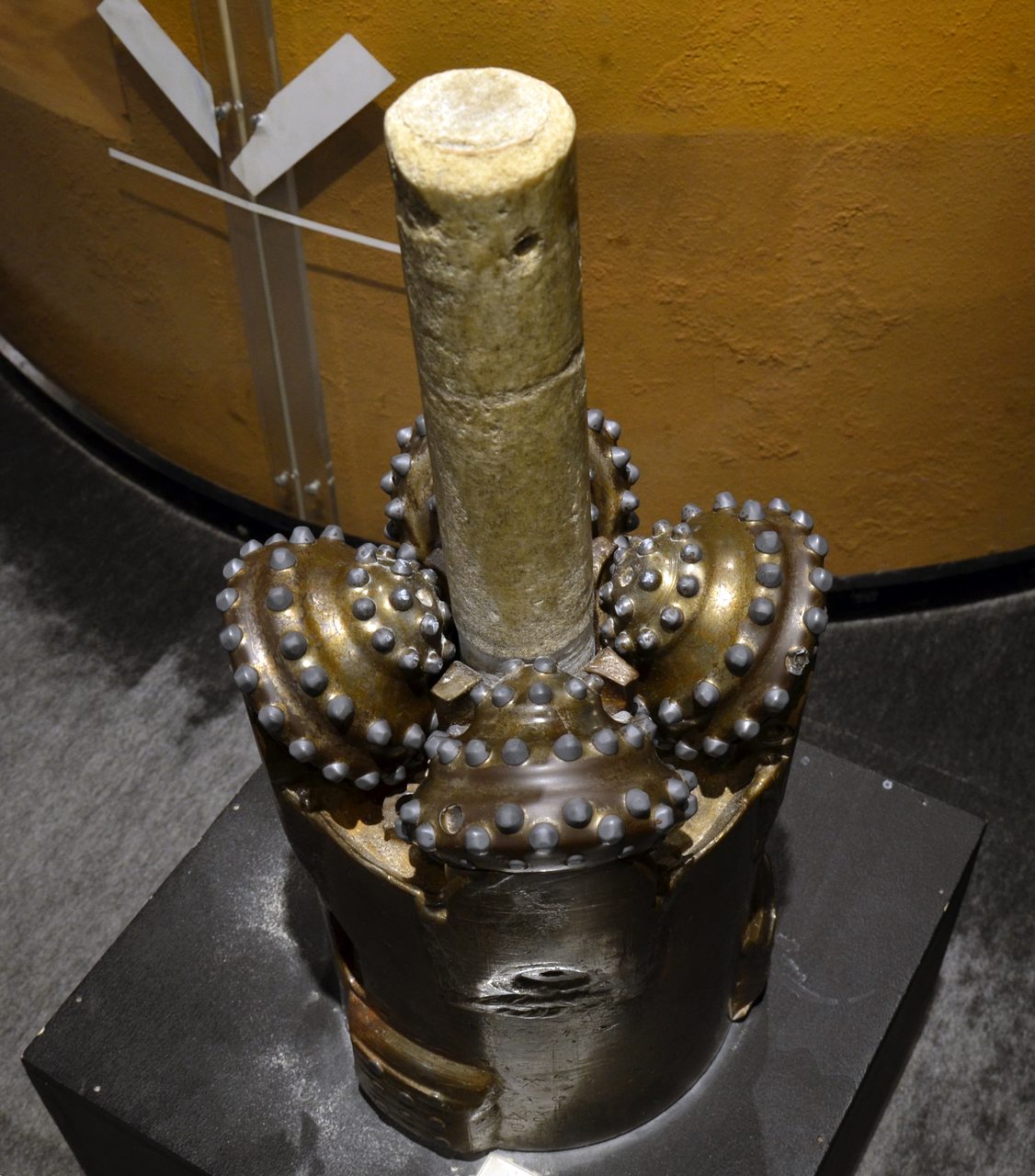
The physical anchor of this story is not a landform and it is not an inference. It is core, pulled out of the seabed and described in a published cruise report.
In 1970, Leg 13 of the Deep Sea Drilling Project drilled a series of sites across the Mediterranean from the vessel Glomar Challenger, under the co-chief scientists William B. F. Ryan and Kenneth Hsu. From beneath the deep seafloor the cores brought up evaporite deposits: halite, gypsum and anhydrite. Those minerals do not precipitate in an open ocean basin. They form when seawater evaporates in a shallow or restricted body of water. The results were published in the Initial Reports of the Deep Sea Drilling Project in 1973.
The same cores carried something the salt alone does not say. Alongside the gypsum, anhydrite and rock salt, Leg 13 recovered arroyo gravels and red and green floodplain silts. An arroyo gravel is a desert stream deposit: it forms in a dry channel that runs in flood and then stands empty. Pulling one out from under two kilometres of Mediterranean water is the most concrete single statement anyone can make about that spot having once been open air. Our own research file does not mention these deposits at all, and if this article could keep only one fact, it would keep this one.
The total volume of Messinian evaporites is estimated at roughly 1 million cubic kilometres. That figure carries an implication that belongs beside it, because the implication is what makes the number make sense: precipitating that much salt out of seawater takes more than one evaporation. The basin was refilled and evaporated repeatedly across the crisis, not once.
That total is softer than a round million sounds. The published framing that carries the figure also states that the estimate may be reduced by 50 to 75 percent as more information becomes available, and the mass figure sometimes quoted next to it is the same estimate expressed a different way, not a second and independent confirmation of it. The honest form is on the order of a million cubic kilometres, not a total.
Where the buried evaporites are thickest they reach as much as 3 km. That is a maximum, not a basin-wide average, and it should never be restated as three kilometres of salt lying evenly under the Mediterranean. This article's title says a kilometre of salt because a kilometre is the conservative end of what the deposit actually reaches, and the conservative end is the one worth putting in a headline.
02The Canyons, And A Correction To Our Own File
If the water level in a basin falls, the rivers feeding it fall with it. They cut down toward the new base level, and they leave the cut behind. Around the Mediterranean those cuts are buried under later sediment, and they are enormous.
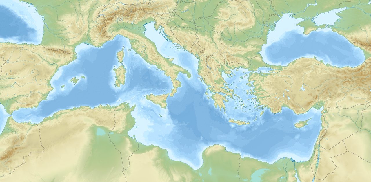
Rivers flowing into the Mediterranean carved deep canyons during the crisis, matching a base level far below the one they had been graded to. The Rhone canyon extends more than 1,000 m deep beneath the present Camargue.
The Nile cut deeper still, and here this article has to correct its own source. The buried Messinian Nile canyon reaches roughly 2,500 m below present sea level just north of Cairo. Our research file's quick summary attaches that same 2,500 m figure to Aswan, roughly 1,000 km upstream, and that is wrong: at Aswan the canyon floor is around 200 m below sea level. The body of the file gives the depth without naming a city and is defensible; the summary line is not, and nobody should carry it forward. The two-city split is standard in the Nile canyon literature, including in the papers that dispute what the canyon means. Honest limit on our end: the ultimate primary source for both figures is older Egyptian subsurface work that this research pass did not fetch directly.
The third line of erosional evidence is not a landform but a surface. Seismic reflection profiles show a prominent erosional horizon, the M-reflector, running across the Mediterranean margins, and an erosional surface of that kind records subaerial exposure: air, weather and running water where there is now a water column. Taken with the canyons, these features are not explicable without a dramatic drop in Mediterranean water level.
How far a drop is the question the middle of this article opens, and the Nile canyon turns out to be the exact ground the argument is now being fought over.
03When It Happened, And Why The Door Closed
The date and the cause are both settled at the top tier in our file, and both are known by inference rather than by witness. It is worth being precise about what kind of inference each one is.
The crisis is dated astronomically rather than by estimate. Krijgsman and colleagues, publishing in Nature in 1999, calibrated Mediterranean sedimentary cycles against the astronomical record and placed the onset at 5.96 million years ago. The end, the Zanclean flood, is dated to 5.33 million years ago. One note on precision: the current major review of the crisis, Krijgsman and colleagues again in Nature Reviews Earth & Environment in 2024, gives the onset as 5.97 million years. That is a refinement of the same astronomical calibration rather than a rival date, and this article uses 5.96 throughout instead of blending the two into a range neither source states.
The cause was tectonic. The African and Eurasian plates converged, progressively restricting and then closing the seaway at the Gibraltar arc that connected the Mediterranean to the Atlantic. Our file's own hedge on this is load-bearing and is kept here intact: the exact geometry and timing of that closure are reconstructed from structural geology and paleogeographic models, not directly observed. That hedge is also precisely where the 2025 challenge below lands.
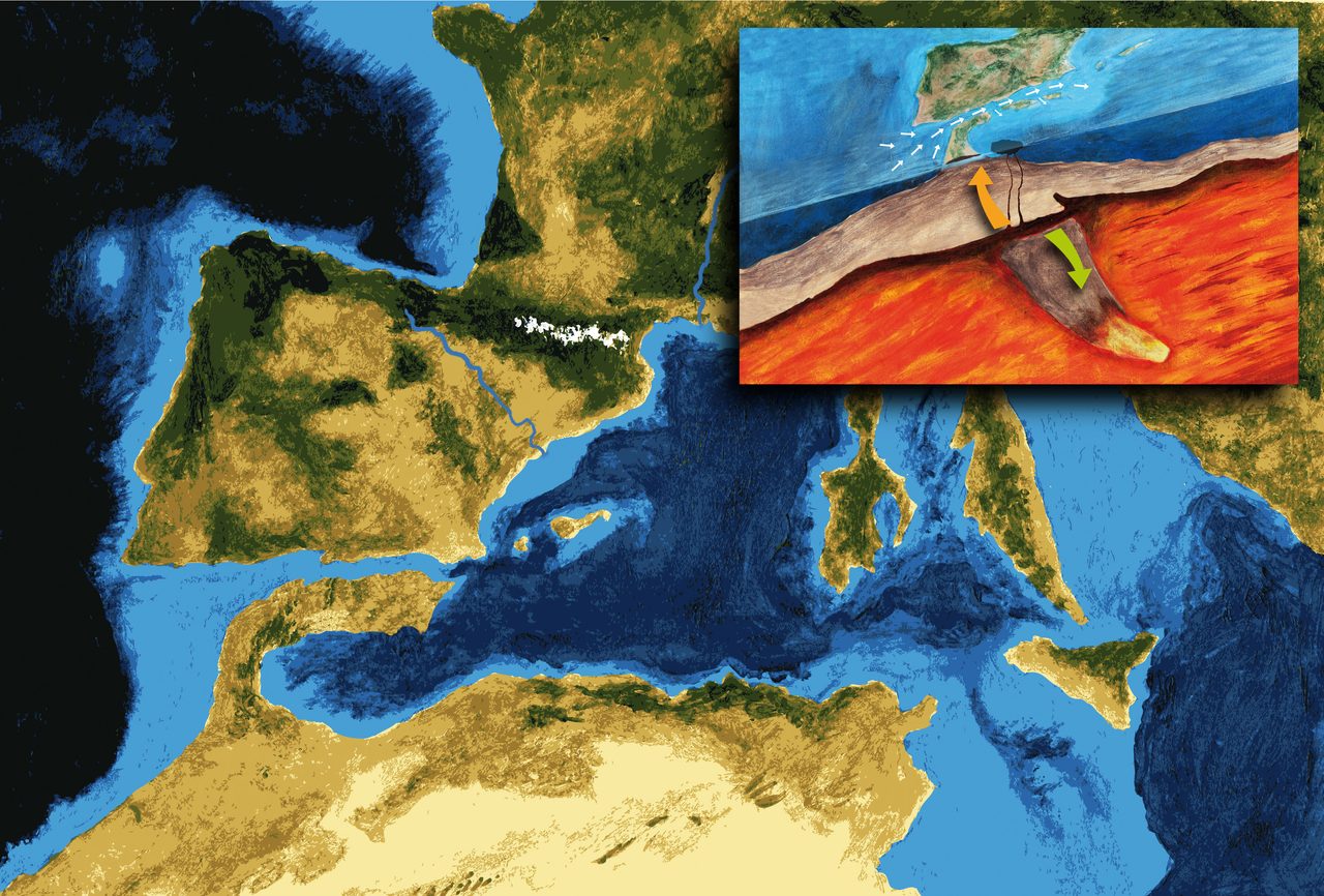
The rest is a water budget. Evaporation from the Mediterranean greatly exceeds the freshwater its rivers deliver. Cut off the Atlantic inflow and the basin, roughly 3.7 million cubic kilometres of water, would dry up in scarcely more than 1,000 years. Notice what kind of statement that is. It is a hydrological calculation about a modern basin, not a measurement of anything that happened. It tells you that drying the Mediterranean is physically easy. It does not tell you how far the drying went.
04How Dry Did It Get
This is the argument the title points at, and it has been running for more than fifty years. It is not a fight between science and speculation. It is two readings of the same rock, each with named proponents and published evidence, and the field has not converged on either.
Kenneth Hsu and colleagues proposed the desiccation model in 1973, in Nature and in the Initial Reports of the Deep Sea Drilling Project: that the Mediterranean had largely or completely dried, leaving a vast salt desert thousands of metres below present sea level. That the proposal was made, by whom, and when, is settled. Whether it is correct is the rest of this section, and it is not settled at all. The Tier 1 status of the proposal must not be allowed to leak into its conclusion.
The deep desiccation model, which our file attributes to Hsu, Clauzon and Garcia-Castellanos, holds that the Mediterranean was reduced to one or more hypersaline lakes, something like the modern Dead Sea, lying at the bottom of a vast depression roughly 3 to 5 km below modern sea level. One caveat on that attribution. Daniel Garcia-Castellanos, named there as a proponent, is a co-author of the 2022 paper below that argues for a far shallower drawdown. The attribution is fair for the position as it stood around 2009 and stale for the position now. Hsu owns the model unambiguously; the others should be dated to their era.
The shallow-water model is not a fringe objection to that. It is the position of a formal international workshop consensus, the CIESM workshop of 2008, and of the field's most-cited modern review, Roveri and colleagues in Marine Geology in 2014. On this reading the evaporites formed in shallow marginal basins while the deep Mediterranean retained water, and the deep basins were never fully desiccated. The same salt, deposited in a different place, under a different sea.
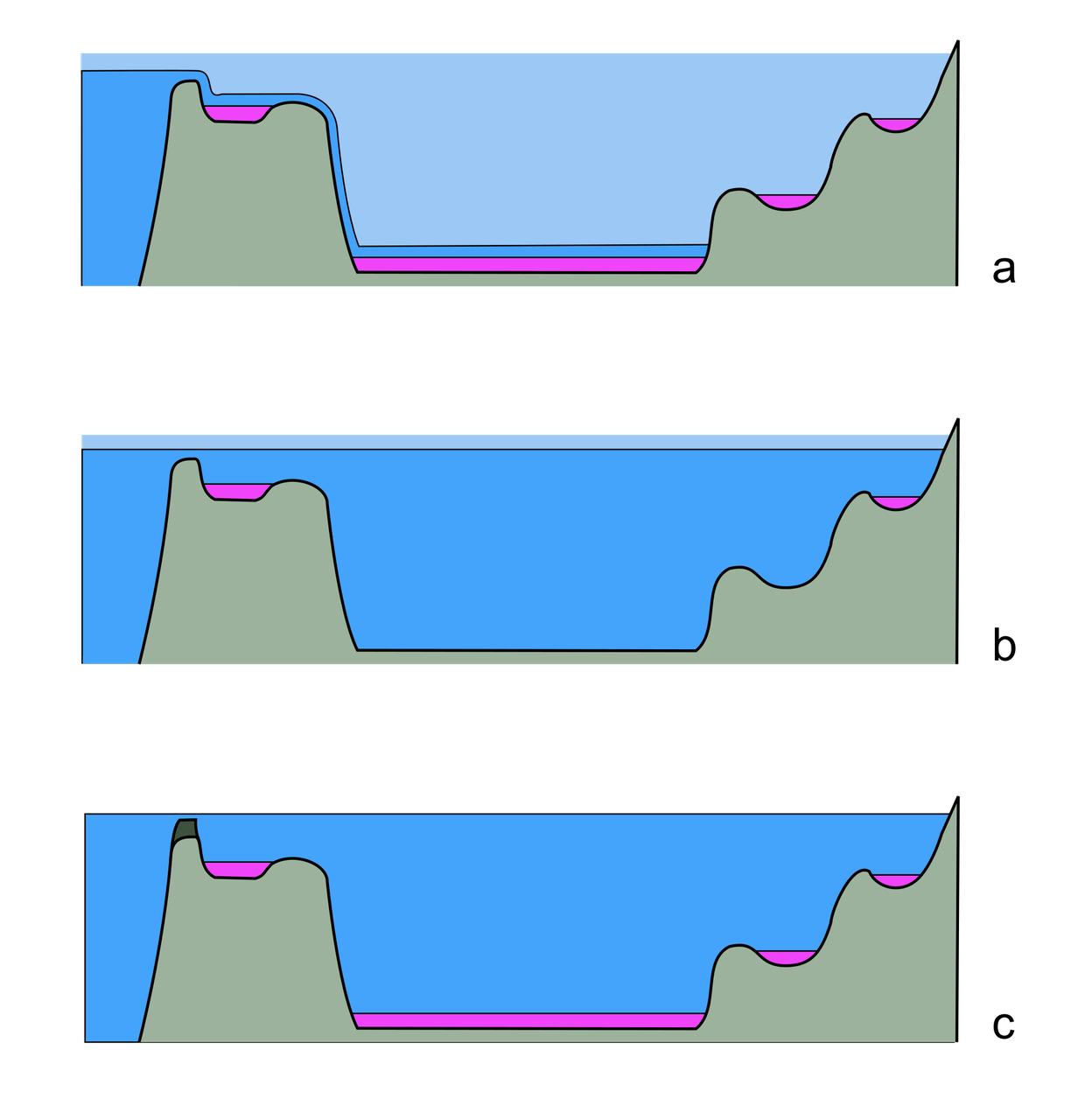
Our own file leans, and the hedge inside its lean is not decoration. It says that seismic evidence supports deep-basin evaporite deposition in at least some areas, favouring substantial, if perhaps not total, desiccation. Those four words, if perhaps not total, are the file declining to say the thing its own quick summary and this article's original working title both wanted it to say.
In 2022 the Nile canyon changed sides. Gvirtzman, Heida, Garcia-Castellanos, Bar, Zucker and Enzel, publishing in Communications Earth & Environment, restored the canyon's original topography and the vertical position of the Messinian coastline by unloading the post-Messinian sediment and accounting for flexural isostasy and compaction. Their estimate for the original depth of the Nile's geomorphological base level is about 600 m below present sea level: a drawdown 2 to 4 times smaller than the raw canyon had been read to imply, with the salt precipitating under 1 to 3 km of water rather than on a dry floor. Their abstract states that this conclusion is at odds with the nearly-desiccated basin model that has dominated the scientific literature for 50 years. Their own closing hedge belongs with it: a 600 m drawdown is still about five times larger than any glacial sea-level fall, so this is a downgrade of the drying, not a denial of it.
The case against went further in 2025. Roveri, Lugli and Manzi, in the Annual Review of Marine Science, published a fifty-year retrospective whose title names part of the standard story as myth. Their abstract states that the megaflood hypothesis rests on an erosional surface cutting upper Miocene rocks and sealed by lower Pliocene sediments, and that recent investigations suggest the connection between the Atlantic and the Mediterranean through Gibraltar may have remained active throughout the crisis, indicating more gradual physical processes and possibly a Mediterranean that was never desiccated. Two limits on how far this article can use that paper. The publisher's page refused our request, so we have read the abstract as deposited with CrossRef and not the paper itself; and an erratum record exists for it in the same series whose content we could not retrieve. Nothing is attributed to it here beyond what that abstract supports, and in particular no specific claim is named as one of the myths of its title.
The other camp has not stopped publishing either. Garcia-Castellanos, Heida, Palcu, Bulian and Sierro, in Science Advances in 2025, present a landscape evolution model in which erosional waves propagating into the surrounding continents added a gradual sea level rise on top of climatic oscillations inside the Mediterranean, offered as an explanation for the transition to fresher-water conditions. It is explicitly a model and it is carried here as one. Its value for this article is that the dispute is not one side advancing on a static opponent. Both camps have gained ground in the same few years.
| Model | Who | What It Says | What It Rests On | What Pushes Against It |
|---|---|---|---|---|
| Deep desiccation | Hsu and colleagues (1973); Clauzon; Garcia-Castellanos in his 2009-era work | The basin was reduced to one or more hypersaline lakes at the bottom of a depression roughly 3 to 5 km below modern sea level | The drilled evaporite body and its arroyo gravels; deep-basin evaporite deposition on seismic profiles; the Rhone and Nile canyons; the M-reflector | Gvirtzman and colleagues (2022) restore the Nile canyon and estimate roughly 600 m of drawdown, with salt precipitating under 1 to 3 km of water, stating in their own abstract that this is at odds with the nearly-desiccated model |
| Shallow water | Roveri and colleagues (2014); the CIESM workshop consensus (2008) | The evaporites formed in shallow marginal basins while the deep Mediterranean kept its water; the deep basins never fully dried | A formal international workshop consensus and the field's most-cited modern review; the reading of the evaporite sequences as marginal-basin deposits | Seismic evidence for deep-basin evaporite deposition in at least some areas, which our own file reads as favouring substantial if perhaps not total desiccation; Micallef and colleagues (2018) find a physical megaflood deposit implying a large drawdown in the Ionian Basin |
| The 2025 sharpening of the shallow reading | Roveri, Lugli and Manzi (2025), Annual Review of Marine Science | Gibraltar may have remained active throughout the crisis, which would mean no full desiccation and no megaflood | A review of fifty years of evidence, arguing that the erosional surface the megaflood case rests on admits more gradual physical processes | The physical flood deposits of Micallef and colleagues (2018 and 2024); and this article could read only the abstract as deposited with CrossRef, with an erratum for the paper that was not retrievable |
One more disagreement belongs here, and it is ours. Our sister file on catastrophic flood geomorphology states flatly that the Mediterranean had evaporated almost completely, reduced to disconnected hypersaline lakes, with no hedge and no rival named. The file this article is built on does not do that, and is right not to. Where our own library disagrees with itself, this article follows the file that carries the dispute rather than the one that resolves it for free.
05The Flood, And Which Numbers Are Measurements
Everything above is about how far down. This part is about how the water came back, and it is the cleanest place in the whole file to show what kind of fact each number is. Some of what follows was measured off rock. Some of it came out of a simulation. One paper contains both at once, which is why it is worth walking through slowly.
Garcia-Castellanos and colleagues, publishing in Nature in 2009, modelled the reopening of the Atlantic connection at the end of the crisis. The simulation produces a catastrophic refill: peak flow rates of up to 100 sverdrups, where one sverdrup is a million cubic metres per second, which puts the peak at roughly 1,000 times the discharge of the Amazon. In the published framing, ninety percent of the basin's flooding happens in an estimated window of somewhere between several months and two years, with complete refilling possibly taking about a decade. Every one of those figures is an output of that model. This is the single most important provenance flag in the article: none of them is a reading taken off anything.
The rest of the flood's superlatives come from the same place and deserve the same label. Sea level inside the basin rising at times by more than 10 metres per day: modelled. Erosion of the Camarinal Sill at 0.4 to 0.7 metres per day: modelled. A water drop of more than 1,000 metres at the breach: modelled. An earlier one-dimensional model assumed a range of more than 10 to 100 sverdrups, which is where the familiar figure entered the literature in the first place. These are not survey data, and the people who produced them never presented them as such.
One caution about apparent corroboration, and it is ours again. Our sister file gives the discharge as up to 100 million cubic metres per second, a thousand times the Amazon. That is arithmetically the same figure as 100 sverdrups, because a sverdrup is a million cubic metres per second. Two of our files carrying one number in different units is not two independent estimates, and it should never be read as agreement between sources.
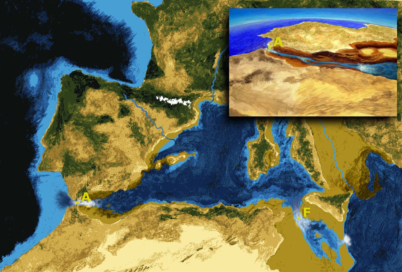
Now the measured side. Garcia-Castellanos and colleagues published a review in Earth-Science Reviews in 2020 asking a pointed question: what evidence for this flood exists independently of the model that proposed it? The main answer they identify is a channel. It runs nearly 390 km from the Gulf of Cadiz in the Atlantic to the Algerian Basin in the western Mediterranean, is several hundred metres deep, and implies the excavation of roughly 1,000 cubic kilometres of Miocene sediment and bedrock. The channel is mapped. What cut it is the argument.
That review's own language is worth carrying rather than smoothing. It calls the kilometre-scale drawdown alleged, and the megaflood one of the competing scenarios proposed for the termination of this environmental crisis. The lead author of the paper that first proposed the flood is the lead author of the review that asks whether the flood holds up independently of it. That is the register this article is trying to match.
The first physical deposit arrived in 2018. Micallef and colleagues, in Scientific Reports, used seismic profiles and borehole data to identify an extensive, buried, chaotic sedimentary body in the western Ionian Basin, sitting above the Messinian salts and below the Plio-Quaternary open-marine sequence, consistent with a megaflood passing from the western into the eastern Mediterranean through a south-eastern Sicilian gateway. Measured off that data: a volume of 1,430 to 1,620 cubic kilometres, an extent of 160 km by 95 km, and a maximum thickness of 760 to 860 m. The paper's abstract argues that the body provides evidence for a large amplitude drawdown in the Ionian Basin, supports a Mediterranean-wide catastrophic flood at the end of the crisis, and suggests this is the largest known megaflood deposit on Earth.
The same paper also carries a peak discharge of roughly 100 million cubic metres per second and a flow velocity of up to 45 metres per second. Those were computed, not measured. This is the teaching case for the whole article: one paper, one team, one set of data, and two entirely different kinds of number inside it. The deposit's size was read off seismic reflection data and boreholes. The discharge and the velocity came out of a calculation. Both are legitimate science. They are not the same kind of fact, and a reader who takes the second for the first has been misled by nothing but the retelling.
In December 2024 the same lead author published land-to-sea evidence in Communications Earth & Environment, for the flood spilling over a shallow-water marine corridor in south-east Sicily. In the field: more than 300 asymmetric, streamlined erosional ridges aligned with the flood direction; poorly sorted breccia deposited between the Messinian and the Lower Zanclean Trubi Formation; soft-sediment deformation structures and clastic injections in the breccia and the units beneath it; and a 20 km wide erosional shelf channel connecting the ridges to the Noto Canyon. Those are observations of rock in outcrop and on the shelf.
The discharge associated with that route, 68 to 100 sverdrups, is again a modelled range and not a measurement. One limit on our own reporting of this paper: we have its findings through institutional publication records and press coverage rather than through its full text, so the detail above should be read as accurately relayed rather than independently checked against the paper's own pages.
There is a named rival for the flood as well as for the drying, and it is a different argument from the one above. Roveri and colleagues in 2014 propose a more gradual refilling through multiple phases, with the most catastrophic flooding confined to the final stage. That is a real third position between a single instantaneous breach and no flood at all.
And a fourth position, on the mechanism rather than the pace. Blanc, in Geodinamica Acta in 2002, argues from the geomorphology of the strait together with budget modelling and hydraulic calculation that the modern Strait of Gibraltar was opened by retrogressive erosion cutting back along an eastward-flowing Messinian stream, and that the Plio-Quaternary strait shares no geographical feature with the Miocene portals, which had been continentalised before the crisis ended. He also reads the widespread Lago-Mare facies as showing that the Mediterranean was fully isolated from the world ocean at the end of the crisis. This article cites that paper for the strait, which is what it is about, and for nothing else.
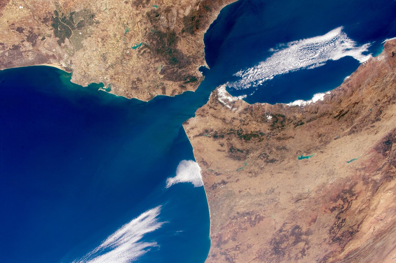
The submarine channel at the Gibraltar sill is real mapped topography, hundreds of metres deep, and a refilling flood would have eroded exactly there. The modern geomorphology of the strait is consistent with that. Reading the channel as the scar of one catastrophic event is the modelled part, and the 2025 review above argues that the same erosional surface admits a gradual explanation instead.
| The Figure | Measured Or Modelled | Where It Comes From |
|---|---|---|
| Halite, gypsum and anhydrite from beneath the deep seafloor, with arroyo gravels and floodplain silts | Measured: recovered rock | DSDP Leg 13, drilled from the Glomar Challenger in 1970 |
| Evaporites up to 3 km thick; total volume on the order of 1 million cubic kilometres | Measured, with a stated caveat | The drilled and seismically imaged evaporite body; the published estimate may fall by 50 to 75 percent as more information arrives |
| Rhone canyon more than 1,000 m deep; Nile canyon roughly 2,500 m below present sea level north of Cairo; the M-reflector across the margins | Measured: mapped landforms and seismic horizons | Borehole and seismic survey of the Mediterranean margins |
| A 390 km erosion channel from the Gulf of Cadiz to the Algerian Basin, implying roughly 1,000 cubic kilometres of excavation | Measured: mapped | Garcia-Castellanos and colleagues (2020), Earth-Science Reviews |
| Ionian Basin deposit: 1,430 to 1,620 cubic kilometres, 160 km by 95 km, 760 to 860 m thick | Measured: seismic profiles and boreholes | Micallef and colleagues (2018), Scientific Reports |
| More than 300 erosional ridges, breccia, and a 20 km wide shelf channel in south-east Sicily | Measured: field observations | Micallef and colleagues (2024), Communications Earth & Environment |
| Peak discharge up to 100 sverdrups; ninety percent of the refill in several months to two years; full refill possibly about a decade | Modelled | Garcia-Castellanos and colleagues (2009), Nature |
| Sea level rise inside the basin of more than 10 m per day; Camarinal Sill erosion at 0.4 to 0.7 m per day; a drop of more than 1,000 m at the breach | Modelled | The same 2009 simulation and the one-dimensional model before it |
| Flow velocity up to 45 m per second; discharge of roughly 100 million cubic metres per second | Modelled, in the same paper whose deposit measurements are not | Micallef and colleagues (2018), Scientific Reports |
| Discharge of 68 to 100 sverdrups for the south-east Sicily route | Modelled | Micallef and colleagues (2024), Communications Earth & Environment |
| A drawdown of roughly 600 m, with salt precipitating under 1 to 3 km of water | Modelled: a restoration of the canyon, unloading sediment and correcting for isostasy and compaction | Gvirtzman and colleagues (2022), Communications Earth & Environment |
| The basin drying in scarcely more than 1,000 years without Atlantic inflow | Calculated: a water budget, not an observation of anything | The standard hydrological framing of the modern Mediterranean |
06What It Did Beyond The Basin
Take that much salt out of the world ocean and the world ocean notices. So, on our file's account, do the climate and the living things at either end of the drained gap. This is the softest part of the file, and one of its claims arrives with two defects that have to be handled in the open.
The claim, first. Removing a large fraction of the world ocean's dissolved salt into the Mediterranean evaporites would have lowered global ocean salinity by roughly 2 to 3 practical salinity units, with possible effects on thermohaline circulation and global climate. Now the two corrections. The first is arithmetic: our file pairs that salinity range with a figure of about 5 percent of the ocean's dissolved salt, and those two numbers do not reconcile, because 5 percent of a roughly 35 psu ocean is about 1.75 psu, not 2 to 3. This article does not restate the pair as though it worked. The second is a citation: the file attaches this claim to Blanc (2002), a paper about the geomorphology of the Gibraltar strait opening that says nothing about global ocean salinity or thermohaline circulation. We do not cite it here for this, and the next claim gives the source we do use.
The current major review frames the same effect more defensibly. Krijgsman and colleagues, in Nature Reviews Earth & Environment in 2024, define salt giants as massive salt deposits at least hundreds of metres thick formed during the evaporation of semi-enclosed seas, and put their effect at roughly 7 to 10 percent net extraction of evaporite ions from ocean water, persisting over million-year timescales, which is their argument for including salt giants in long-term carbon cycle models. They also identify calcium removal during salt precipitation as a mechanism that altered ocean chemistry and through it affected atmospheric carbon dioxide and global temperature. Note that an extraction of that size would give roughly 2.5 to 3.5 psu, close to the range our file states, so it may well be the percentage in our file that is stale rather than the salinity figure.
Closer to home, the crisis may have contributed to late Miocene climate cooling and to aridification in the Mediterranean region, with cascading effects on North African and Southern European ecosystems. The may have is our file's own wording and it stays exactly where it is.
With the sea down, there was a temporary land bridge between Africa and Europe, and the episode is sometimes called the Messinian terrestrial crisis. Some evidence suggests mammalian dispersals between the two continents in this window, but the record is sparse, which is why it sits here rather than higher. One thing needs saying plainly, because the phrase land bridge pulls English toward a picture it does not license. The animals crossing were late Miocene mammals; camelids and gerbils are the creatures named in the standard illustrated reconstruction of the crossing. There were no people. There would be no people anywhere near this region for millions of years.
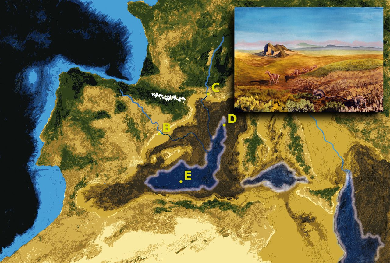
Inside the basin, the extreme environments the crisis produced, hypersaline lakes, salt flats and deep canyons, may have driven speciation and extinction among Mediterranean marine organisms. The fossil evidence is limited and the claim stays speculative on our file's own assessment.
07The One Claim The Evidence Refuses
One connection gets made to this event more often than any other, and it is the single thing here that can be answered with a flat no.
No, the Zanclean flood cannot be connected to any human cultural memory or flood mythology. It was a genuine geological catastrophe with extensive physical evidence behind it, and it happened roughly 5.33 million years ago, millions of years before any hominins inhabited the Mediterranean region. There was no witness, no survivor, and no consequence for any person. Connecting an event of that age to human flood traditions is anachronistic, and our file labels it debunked without qualification. Every superlative in this article describes a planet with nobody on it.
Fast Facts
- The Event
- The Messinian Salinity Crisis: the restriction, evaporation and refilling of the Mediterranean at the end of the Miocene
- When
- 5.96 to 5.33 million years ago, dated by astronomical calibration of Mediterranean sedimentary cycles
- The Cause
- African and Eurasian plate convergence restricting and closing the seaway at the Gibraltar arc; the exact geometry and timing are reconstructed, not observed
- What Was Drilled
- Halite, gypsum and anhydrite from beneath the deep seafloor, plus arroyo gravels and floodplain silts, by DSDP Leg 13 from the Glomar Challenger in 1970
- The Salt
- Up to 3 km thick where thickest; on the order of 1 million cubic kilometres in total, an estimate its own literature says may fall by 50 to 75 percent
- The Canyons
- The Rhone canyon more than 1,000 m deep beneath the Camargue; the Nile canyon roughly 2,500 m below present sea level north of Cairo, and around 200 m at Aswan
- How Dry
- Disputed. Deep desiccation puts hypersaline lakes roughly three to five kilometres below modern sea level; the shallow-water model has the deep basins never fully drying; a 2022 restoration of the Nile canyon estimates roughly 600 m of drawdown
- The Refill
- The Zanclean flood at 5.33 million years ago; modelled at up to 100 sverdrups peak discharge, with an estimated ninety percent of the flooding inside several months to two years
- Physical Flood Evidence
- A 390 km erosion channel from the Gulf of Cadiz to the Algerian Basin; a deposit of 1,430 to 1,620 cubic kilometres in the Ionian Basin; more than 300 erosional ridges and breccia in south-east Sicily
- Global Effect
- Salt giants are estimated at roughly 7 to 10 percent net extraction of evaporite ions from ocean water; our file's own paired salinity figures do not reconcile and are corrected above
- Life
- A temporary land bridge between Africa and Europe with sparse evidence of mammalian dispersal; possible speciation and extinction among Mediterranean marine organisms
- Human Connection
- None. This is millions of years before any hominin lived anywhere near the Mediterranean, and our file files the flood-myth link as debunked
What We Can Actually Stand Behind
The evaporites are real and they were drilled. In 1970 Leg 13 of the Deep Sea Drilling Project cored halite, gypsum and anhydrite from beneath the deep Mediterranean seafloor, along with arroyo gravels and floodplain silts that only form in open air. The deposit reaches as much as 3 km thick and amounts to on the order of 1 million cubic kilometres. Rivers cut canyons into the margins to match a fallen base level, the Rhone more than 1,000 m deep beneath the Camargue and the Nile to roughly 2,500 m below present sea level north of Cairo. An erosional surface, the M-reflector, shows on seismic profiles across the margins. The crisis is astronomically dated to 5.96 to 5.33 million years ago, and the cause is read as plate convergence closing the seaway at the Gibraltar arc. The rock, the canyons, the erosional surface and the dates are not seriously disputed by anyone; the closure itself carries the hedge set out above, and the line below.
There is also a genuine argument here, and it is between two positions that both carry evidence. Deep desiccation has been the dominant reading for fifty years and rests on deep-basin evaporites, the canyons and the erosional surface. The shallow-water model is the position of a formal international workshop consensus and of the field's most-cited modern review, and it has the evaporites forming in shallow marginal basins with the deep Mediterranean never fully drying. Since our own file was last updated, physical evidence has grown on both sides: a measured megaflood deposit in the Ionian Basin and mapped erosional ridges in south-east Sicily on one hand, a restored Nile canyon and a 2025 review arguing Gibraltar may never have closed on the other. This article names no winner, because the field has not.
Almost every number the retellings love is a model output. Peak discharge of up to 100 sverdrups; an estimated ninety percent of the refill inside several months to two years; sea level rising by more than 10 m per day; Camarinal Sill erosion estimated at 0.4 to 0.7 m per day; a drop of more than 1,000 m at the breach; and the 68 to 100 sverdrups estimated for the south-east Sicily route. All computed, none measured. The drawdown estimate of roughly 600 m is likewise a restoration rather than a reading, and its own authors say so while noting that it is still about five times any glacial sea-level fall. The global salinity effect belongs here too, at roughly 7 to 10 percent net ion extraction on the current review's framing, with our own file's paired figures corrected above. Treat all of these as the best available calculations, which is exactly what they are, and never as survey data, which is exactly what they are not.
The biological consequences sit here. A temporary land bridge between Africa and Europe with mammalian dispersals across it, sometimes called the Messinian terrestrial crisis, resting on a sparse record. Speciation and extinction driven by hypersaline lakes, salt flats and canyons inside the basin, resting on limited fossil evidence. Both are plausible and neither is demonstrated. And the crossers on that bridge were late Miocene mammals, not anybody's ancestors in any story a human being has ever told.
No, this is not the event behind any flood myth. The Zanclean flood happened roughly 5.33 million years ago. No hominin lived anywhere near the Mediterranean then, so there was no witness, no survivor and no memory to hand down. Any telling that runs this event into a human flood tradition has crossed a gap of millions of years without noticing it, and our own file files that connection as debunked.
So the file closes on a distinction rather than an answer. We have the rock: salt and gypsum and anhydrite out of the cores, desert stream gravel from under two kilometres of water, canyons cut into the margins, an erosional surface across the basin, a flood deposit in the Ionian Basin, ridges scoured into the Sicilian shelf. We have the models too, and they are good models, and they are where the numbers everyone repeats actually come from. What we do not have is agreement about the thing the old title asserted. A nearly desiccated basin has dominated the literature for half a century, and in the last few years the people best placed to know have been arguing hard, with new field data on both sides, about whether that was ever the right reading. Which leaves a question worth sitting with. If a claim can hold a field for fifty years on evidence this good and still come under this much pressure, what is the honest thing to say about it while the argument runs, and how would you know when it stopped being true?
Sources & further reading
Everything above is drawn from our research library on Theories of Anything, principally file E_3_09, together with the external papers named in the prose. Four things about the sourcing should be said in the open. First, four works cited in our own file carry no DOI or ISBN anywhere in the corpus and none was located: the CIESM workshop monograph (2008), Lofi and colleagues (2011), Manzi and colleagues (2010), and Hsu's book The Mediterranean Was a Desert (1983). They are named by author and year rather than linked, because pointing a reader at a guessed identifier would be worse than offering none. Second, three of the recent papers were read to different depths and the difference matters: Micallef and colleagues (2018) was read from the open-access copy; Roveri, Lugli and Manzi (2025) and Garcia-Castellanos and colleagues (2025) both returned publisher access blocks, so only the abstracts as deposited with CrossRef were read, and an erratum record exists for the Roveri 2025 paper in the same series whose content could not be retrieved, so nothing is attributed to it beyond its abstract; and the findings of Micallef and colleagues (2024) reached us through institutional publication records and press coverage rather than the paper's own full text. Third, our own file contains three defects this article corrects rather than repeats: its quick summary attaches the 2,500 m Nile canyon depth to Aswan when that figure belongs to the reach north of Cairo, its salinity bullet pairs two numbers that do not reconcile, and it cites Blanc (2002) for a global-salinity claim that paper does not make. Blanc (2002) is linked below for what it is actually about, the opening of the Gibraltar strait. Fourth, our file's header lists a cross-reference that resolves to an unrelated document; it is not linked here. Every DOI below was resolved individually against CrossRef and its returned title, authors, venue, volume, pages and year compared with the citation as carried. Open the full file to check the sourcing and go deeper.
Image credits
- messinian-salinity-crisis-sorbas-gypsum-yesares.jpg Verisimilus, own work (CC BY 3.0 Unported). CC BY 3.0 Unported Source.
- messinian-salinity-crisis-glomar-challenger-drill-bit.jpg Vassil, own work, Naturhistorisches Museum Basel (CC0 1.0 Public Domain Dedication). CC0 1.0 Public Domain Dedication Source.
- messinian-salinity-crisis-mediterranean-relief-map.jpg Nzeemin, own work from the ETOPO1 relief and bathymetry dataset and the GSHHS coastline dataset (CC BY-SA 4.0). CC BY-SA 4.0 Source.
- messinian-salinity-crisis-last-canal-reconstruction.jpg Pau Bahi, artistic interpretation (CC BY-SA 3.0). CC BY-SA 3.0 Source.
- messinian-salinity-crisis-basin-hypotheses-diagram.png Verisimilus, own work (CC BY 3.0 Unported). CC BY 3.0 Unported Source.
- messinian-salinity-crisis-zanclean-flood-reconstruction.jpg Pau Bahi, lettering by Dvdgmz, under the scientific supervision of Daniel Garcia-Castellanos, Institute of Earth Sciences Jaume Almera (CSIC) (CC BY-SA 3.0). CC BY-SA 3.0 Source.
- messinian-salinity-crisis-strait-of-gibraltar-iss.jpg NASA, photographed by astronaut Scott Kelly aboard the International Space Station (Public Domain). Public Domain Source.
- messinian-salinity-crisis-drying-reconstruction.jpg Pau Bahi, lettering by Dvdgmz, under the scientific supervision of Daniel Garcia-Castellanos, Institute of Earth Sciences Jaume Almera (CSIC) (CC BY-SA 3.0). CC BY-SA 3.0 Source.
- Card crop of messinian-salinity-crisis-mediterranean-relief-map.jpg Nzeemin, own work from the ETOPO1 relief and bathymetry dataset and the GSHHS coastline dataset (CC BY-SA 4.0). CC BY-SA 4.0 Source.


